Baroy

Last updated
Baroy
Municipality of Baroy
Flag of Baroy, Lanao del Norte.png
Baroy Lanao del Norte.png
Ph locator lanao del norte baroy.png
Map of Lanao del Norte with Baroy highlighted
OpenStreetMap
Baroy
Philippines location map (square).svg
Red pog.svg
Baroy
Location within the Philippines
Coordinates: 8°02′N123°47′E / 8.03°N 123.78°E / 8.03; 123.78
Country Philippines
Region Northern Mindanao
Province Lanao del Norte
District 1st district
Founded June 10, 1949
Barangays 23 (see Barangays)
Government
[1]
  Type Sangguniang Bayan
   Mayor Grelina Mantohac-Lim
   Vice Mayor Rosa D. Olafsson
   Representative Mohamad Khalid Q. Dimaporo
   Municipal Council
Members
  • Edwin R. Ong I
  • Eric C. Basalo
  • Rudiric S. Rizon
  • Sulpicia D. Abamonga
  • Romuel John G. Buhat
  • Gilbert J. Jumawan
  • Rhizie C. Sularte
  • Manuel D. Roda
   Electorate 19,290 voters (2025)
Area
[2]
  Total
72.35 km2 (27.93 sq mi)
Elevation
17 m (56 ft)
Highest elevation
223 m (732 ft)
Lowest elevation
0 m (0 ft)
Population
 (2024 census) [3]
  Total
24,763
  Density340/km2 (890/sq mi)
   Households
6,585
Economy
   Income class 4th municipal income class
   Poverty incidence
23.45
% (2021) [4]
   Revenue 353.1 million (2022)
   Assets 446.9 million (2022)
   Expenditure 134.3 million (2022)
   Liabilities 93.78 million (2022)
Service provider
  ElectricityLanao del Norte Electric Cooperative (LANECO)
Time zone UTC+8 (PST)
ZIP code
9210
PSGC
IDD : area code +63(0)63
Native languages Maranao
Cebuano
Binukid
Tagalog
Website www.baroy.gov.ph

Baroy, officially the Municipality of Baroy (Maranao: Inged a Baroy; Cebuano : Lungsod sa Baroy; Tagalog : Bayan ng Baroy), is a municipality in the province of Lanao del Norte, Philippines. According to the 2020 census, it has a population of 24,683 people. [5]

Contents

History

As early as 1918, Baroy was originally called Baloy, a plant commonly found in the community that is used for mat weaving. Later on, the said plant became extinct and the inhabitants of the locality decided to change the name to Baroy.

The municipality of Baroy was formerly a mere barrio of the municipal district of Kolambugan. When Tubod was separated from Kolambugan (Republic Act No. 58, October 17, 1946), the barrios of Baroy, Sagadan, and Princesa were brought along with it. It became a regular municipality on June 10, 1949, by virtue of Executive Order No. 222 during the term of President Elpidio L. Quirino. The act stated that the municipality of Baroy would be separated from Tubod, and that parts of Kolambugan would be annexed to the two towns.

On January 13, 1960, the town of Salvador was separated from the town through Executive Order No. 370.

Baroy celebrates Lechon Festival every 10th day of June.

Geography

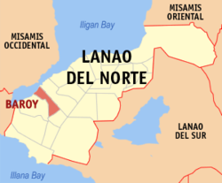
Baroy is located about 69 kilometres (43 mi) south-west of Iligan City. Geographically, Baroy is bordered on the north by Panguil Bay and on the east by the Municipality of Tubod, on the south by the Municipality of Salvador, on the west by the Municipality of Lala.

Baroy has a total area of approximately 8,009.2935 hectares. The agricultural land is approximately 5,348.3994 hectares. Coco lands accounted to about 4,921.6994 hectares and the remaining 426.70 hectares are devoted to rice production. Of said rice lands, 251.2 hectares are irrigated while 175.50 hectares are rainfed area.

Barangays

Baroy is politically subdivided into 23 barangays. Each barangay consists of puroks while some have sitios.

  • Andil
  • Bagong Dawis
  • Baroy Daku
  • Bato
  • Cabasagan
  • Dalama
  • Libertad
  • Limwag
  • Lindongan
  • Maliwanag
  • Manan-ao
  • Pange
  • Pindolonan
  • Poblacion
  • Princesa
  • Rawan Point
  • Riverside
  • Sagadan (Sagadan Lower)
  • Salong
  • Tinubdan
  • Sagadan Upper
  • San Juan
  • Village

Climate

Climate data for Baroy, Lanao del Norte
MonthJanFebMarAprMayJunJulAugSepOctNovDecYear
Mean daily maximum °C (°F)29
(84)
30
(86)
31
(88)
31
(88)
30
(86)
30
(86)
29
(84)
30
(86)
30
(86)
30
(86)
30
(86)
30
(86)
30
(86)
Mean daily minimum °C (°F)22
(72)
22
(72)
22
(72)
23
(73)
24
(75)
24
(75)
24
(75)
24
(75)
24
(75)
24
(75)
23
(73)
23
(73)
23
(74)
Average precipitation mm (inches)69
(2.7)
58
(2.3)
67
(2.6)
60
(2.4)
109
(4.3)
114
(4.5)
83
(3.3)
78
(3.1)
76
(3.0)
92
(3.6)
86
(3.4)
63
(2.5)
955
(37.7)
Average rainy days12.811.614.817.424.823.520.718.517.422.521.615.6221.2
Source: Meteoblue [6]

Demographics

Population census of Baroy
YearPop.±% p.a.
1960 11,925    
1970 11,076−0.73%
1975 12,995+3.26%
1980 14,078+1.61%
1990 18,897+2.99%
1995 21,353+2.32%
2000 20,392−0.98%
2007 21,430+0.69%
2010 20,948−0.82%
2015 22,600+1.46%
2020 24,683+1.87%
2024 24,763+0.08%
Source: Philippine Statistics Authority [7] [8] [9] [10] [11]

Economy

Poverty incidence of Baroy

10
20
30
40
50
60
2000
58.14
2003
54.88
2006
45.80
2009
47.01
2012
44.56
2015
40.43
2018
17.11
2021
23.45

Source: Philippine Statistics Authority [12] [13] [14] [15] [16] [17] [18] [19]

The economy of Baroy is derived mainly from small establishments and agriculture.

1st Valley Bank, a rural bank with a number of branches in Mindanao, have their headquarters in Baroy. A branch of MLhuillier is also situated in the town.

Tourism

Healthcare

The town is served by the Lanao del Norte Provincial Hospital. The hospital also serves the nearby towns. The hospital is not yet developed fully.

There are also many health centers in the town. The main Health center is in poblacion near the municipal hall.

Education

Lanao del Norte National Comprehensive High School (which also serves the nearby towns) in Barangay Santo Niño Village and Diosdado Yap Sr. National High School in Barangay Dalama are the only secondary schools in the town. There is also a private school which is known as Santo Niño Academy which was founded by Rev. Fr. John Patrick Meaney.

There are also few elementary schools. One is the Baroy Central Elementary School situated in Poblacion.

References

  1. Municipality of Baroy | (DILG)
  2. "2015 Census of Population, Report No. 3 – Population, Land Area, and Population Density" (PDF). Philippine Statistics Authority. Quezon City, Philippines. August 2016. ISSN   0117-1453. Archived (PDF) from the original on May 25, 2021. Retrieved July 16, 2021.
  3. "2024 Census of Population (POPCEN) Population Counts Declared Official by the President". Philippine Statistics Authority. 17 July 2025. Retrieved 18 July 2025.
  4. "PSA Releases the 2021 City and Municipal Level Poverty Estimates". Philippine Statistics Authority. 2 April 2024. Retrieved 28 April 2024.
  5. "2024 Census of Population (POPCEN) Population Counts Declared Official by the President". Philippine Statistics Authority. 17 July 2025. Retrieved 18 July 2025.
  6. "Baroy: Average Temperatures and Rainfall". Meteoblue. Retrieved 30 January 2020.
  7. "2024 Census of Population (POPCEN) Population Counts Declared Official by the President". Philippine Statistics Authority. 17 July 2025. Retrieved 18 July 2025.
  8. Census of Population (2015). "Region X (Northern Mindanao)". Total Population by Province, City, Municipality and Barangay. Philippine Statistics Authority . Retrieved 20 June 2016.
  9. Census of Population and Housing (2010). "Region X (Northern Mindanao)" (PDF). Total Population by Province, City, Municipality and Barangay. National Statistics Office . Retrieved 29 June 2016.
  10. Censuses of Population (1903–2007). "Region X (Northern Mindanao)". Table 1. Population Enumerated in Various Censuses by Province/Highly Urbanized City: 1903 to 2007. National Statistics Office.
  11. "Province of". Municipality Population Data. Local Water Utilities Administration Research Division. Retrieved 17 December 2016.
  12. "Poverty incidence (PI):". Philippine Statistics Authority. Retrieved December 28, 2020.
  13. "Estimation of Local Poverty in the Philippines" (PDF). Philippine Statistics Authority. 29 November 2005.
  14. "2003 City and Municipal Level Poverty Estimates" (PDF). Philippine Statistics Authority. 23 March 2009.
  15. "City and Municipal Level Poverty Estimates; 2006 and 2009" (PDF). Philippine Statistics Authority. 3 August 2012.
  16. "2012 Municipal and City Level Poverty Estimates" (PDF). Philippine Statistics Authority. 31 May 2016.
  17. "Municipal and City Level Small Area Poverty Estimates; 2009, 2012 and 2015". Philippine Statistics Authority. 10 July 2019.
  18. "PSA Releases the 2018 Municipal and City Level Poverty Estimates". Philippine Statistics Authority. 15 December 2021. Retrieved 22 January 2022.
  19. "PSA Releases the 2021 City and Municipal Level Poverty Estimates". Philippine Statistics Authority. 2 April 2024. Retrieved 28 April 2024.