Panguil Bay

Last updated

Panguil Bay
Ozamiz port.jpg
The Port of Ozamiz situated within the bay
Philippines relief location map (Mindanao).svg
Red pog.svg
Panguil Bay
Location within the Philippines
Philippines relief location map (square).svg
Red pog.svg
Panguil Bay
Panguil Bay (Philippines)
Location Mindanao Island, Philippines
Coordinates 8°02′00″N123°44′00″E / 8.0333333333333°N 123.73333333333°E / 8.0333333333333; 123.73333333333
Type Bay
Part of Iligan Bay
Max. length41 km (25 mi)
Max. width11.5 km (7.1 mi)
Surface area180 km2 (69 sq mi)
Average depth15.4 m (51 ft)
Max. depth55 m (180 ft)
Shore length1112 km (70 mi)
Settlements
1 Shore length is not a well-defined measure.

Panguil Bay is an arm of Iligan Bay in Mindanao, Philippines. [1] The bay forms the natural boundary separating the Zamboanga Peninsula from the rest of the island of Mindanao. It borders the provinces of Misamis Occidental, Zamboanga del Sur, and Lanao del Norte. [2] Important cities and municipalities on its coast are Ozamiz and Tangub in Misamis Occidental, and Tubod, the capital of Lanao del Norte. [1]

Contents

The entrance to the bay is marked by a lighthouse on the west side of Panguil Bay, located on a headland on the eastern side of Ozamiz harbor. The 9-metre (30 ft) high concrete tower has a focal plane of 17 metres (56 ft) with two red flashes every 10 seconds. [3]

The Panguil Bay Bridge is a two-lane bridge under construction, connecting Tangub with Tubod, that are currently linked by a ferry service. The 3.48-kilometre (2.16 mi) bridge will reduce the travel time between Tangub and Tubod from 2.5 hours to 7 minutes. The 7.375-billion construction project started in 2020. [4] [5]

Geography

Panguil Bay is about 41 kilometres (25 mi) long, and has an area of 18,000 hectares (44,000 acres) [2] with a coastline of 112 kilometres (70 mi). At its narrowest point between Tangub and Tubod, the bay is 1.7 kilometres (1.1 mi) wide, while it is 11.5 kilometres (7.1 mi) wide at the bay's mouth. The bottom topography is irregular with an average depth of 15.4 metres (51 ft) and a maximum depth of about 55 metres (180 ft). [6]

There are 29 major and 46 minor river tributaries into the bay, [6] originating from two mountain ranges. In total the bay has a catchment area of 309,738 hectares (765,380 acres). [2]

At the mouth of the bay, there are two coral reefs: the Hulaw-Hulaw Reef on Loculan Shoals near Clarin, Misamis Occidental, and the Maigo Reef near Maigo, Lanao del Norte. Both reefs experience high sedimentation rates and are in fair to poor condition. [7]

History

Fuerte de la Concepcion y del Triunfo Fuerte de la Concepcion y del Triunfo walls.jpg
Fuerte de la Concepcion y del Triunfo

In the 1750s, the Fuerte de la Concepcion y del Triunfo in the town of Misamis, (now the modern city of Ozamiz) was built by the Spanish to guard the entrance to Panguil Bay. At that time Moro pirate raids were at their peak, and the bay was described as a "never ending source of Muslim pirates". [8] In 1917, a lighthouse was built on the eastern bastion of the Spanish Fort. [3]


Ecology

The bay was once a rich fishing ground, with the most abundant species being the gray mullet ( Mugil cephalus ), anchovy ( Stolephorus commersonnii ) and oil sardine ( Sardinella longiceps ). [6] Other important species are penaeid shrimps and prawns, gobies, pony fishes, blue crabs, therapons, carangids, lantern fishes, and hairtails. In 1980, there were about 4,000 fishermen, increasing to over 9,800 in 1995. [2]

Panguil Bay has suffered for decades from overfishing and destructive fishing practices. One of the biggest contributor of over-exploitation was the extensive use of filter nets, locally called sanggab. These nets trap all marine organisms, even macroplankton, depleting the food chain in the bay. Compared to 1984, the number of fish species dropped from 201 to 121 by the mid 1990s. [6] [9]

Further degradation resulted from destruction of natural habitats (such as mangroves turned into fishponds), pollution by poisonous chemicals, and increasing human development along the bay's shore. The sharp decline in fish catch prompted rehabilitation efforts that included the removal of illegal fishing structures such as the filter nets that numbered in the thousands in the 2010s. [10]

Related Research Articles

<span class="mw-page-title-main">Mindanao</span> Island in the Philippines

Mindanao is the second-largest island in the Philippines, after Luzon, and seventh-most populous island in the world. Located in the southern region of the archipelago, the island is part of an island group of the same name that also includes its adjacent islands, notably the Sulu Archipelago. According to the 2020 census, Mindanao has a population of 26,252,442 people, while the entire island group has an estimated population of 27,021,036 according to the 2021 census.

<span class="mw-page-title-main">Northern Mindanao</span> Administrative region of the Philippines

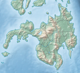
Northern Mindanao is an administrative region in the Philippines, designated as Region X. It comprises five provinces: Bukidnon, Camiguin, Misamis Occidental, Misamis Oriental, and Lanao del Norte, and two cities classified as highly urbanized, all occupying the north-central part of Mindanao island, and the island-province of Camiguin. The regional center is Cagayan de Oro. Lanao del Norte was transferred to Northern Mindanao from Region XII by virtue of Executive Order No. 36 in September 2001.

<span class="mw-page-title-main">Misamis Occidental</span> Province in Northern Mindanao, Philippines

Misamis Occidental, officially the Province of Misamis Occidental, is a province located in the region of Northern Mindanao in the Philippines. Its capital is the city of Oroquieta. The province borders Zamboanga del Norte and Zamboanga del Sur to the west and is separated from Lanao del Norte by Panguil Bay to the south and Iligan Bay to the east. The province of Misamis was originally inhabited by Subanens who were an easy target by the sea pirates from Lanao.

<span class="mw-page-title-main">Lanao del Norte</span> Province in Northern Mindanao, Philippines

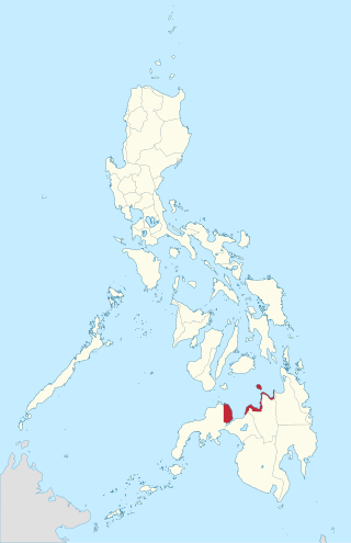
Lanao del Norte, officially the Province of Lanao del Norte, is a province in the Philippines located in the Northern Mindanao region. Its capital is Tubod.

<span class="mw-page-title-main">Iligan Bay</span> Bay in Philippines

Iligan Bay is a bay in Mindanao Island in the Philippines. The bay is part of the Bohol Sea, and curves into the northern coast of Mindanao Island.

<span class="mw-page-title-main">Ozamiz</span> Component city in Misamis Occidental, Philippines

Ozamiz, officially the City of Ozamiz, is a 3rd class component city in the province of Misamis Occidental, Philippines. According to the 2020 census, it has a population of 140,334 people.

<span class="mw-page-title-main">Tangub</span> Component city in Misamis Occidental, Philippines

Tangub, officially the City of Tangub, is a 4th class component city in the province of Misamis Occidental, Philippines. According to the 2020 census, it has a population of 68,389 people.

<span class="mw-page-title-main">Kolambugan</span> Municipality in Lanao del Norte, Philippines

Kolambugan, officially the Municipality of Kolambugan, is a 4th class municipality in the province of Lanao del Norte, Philippines. According to the 2020 census, it has a population of 28,265 people.

<span class="mw-page-title-main">Lala, Lanao del Norte</span> Municipality in Lanao del Norte, Philippines

Lala, officially the Municipality of Lala, is a 1st class municipality in the province of Lanao del Norte, Philippines. According to the 2020 census, it has a population of 73,425 people.

<span class="mw-page-title-main">Maigo</span> Municipality in Lanao del Norte, Philippines

Maigo, officially the Municipality of Maigo, is a 4th class municipality in the province of Lanao del Norte, Philippines. According to the 2020 census, it has a population of 23,337 people.

<span class="mw-page-title-main">Tubod, Lanao del Norte</span> Capital of Lanao del Norte, Philippines

Tubod, officially the Municipality of Tubod,, is a 2nd class municipality and capital of the province of Lanao del Norte, Philippines. According to the 2020 census, it has a population of 60,182 people.

<span class="mw-page-title-main">Labo Airport</span> Airport in Ozamiz, Misamis Occidental, Philippines

Labo Airport, also known as Ozamiz Airport, is an airport serving the general area of the city of Ozamiz in the Philippines. It is the only airport in the province of Misamis Occidental. The airport is classified as a community airport by the Civil Aviation Authority of the Philippines, a body of the Department of Transportation that is responsible for the operations of not only this airport but also of all other airports in the Philippines except the major international airports. It is one of only two community airports in the Philippines with commercial operations, but one of the busiest in Mindanao in terms of aircraft movement and passenger traffic.

<span class="mw-page-title-main">Roman Catholic Archdiocese of Ozamiz</span> Archdiocese of the Catholic Church in the Philippines

The Roman Catholic Archdiocese of Ozamis is a metropolitan archdiocese of the Roman Catholic Church in the province of Misamis Occidental, southern Philippines. The archdiocese cathedral is the Metropolitan Cathedral of the Immaculate Conception in Ozamiz City, and its present archbishop is Martin Jumoad. The official spelling of the church is Ozamis, while the city it is located is Ozamiz.

<span class="mw-page-title-main">Misamis (province)</span> Former province of the Philippines

Misamis was a province of the Philippines located in Mindanao. Originally a Spanish-era district, became a chartered province on May 15, 1901. The province was dissolved in 1929.

<span class="mw-page-title-main">Port of Ozamiz</span> Port in the Philippines

The Port of Ozamiz or Ozamiz Port, is a seaport in Ozamiz City, Misamis Occidental, Philippines. Located in Panguil Bay, it is one of the major gateway ports in the Philippines. It is managed by and the baseport of Philippine Ports Authority - Port Management Office Misamis Occidental/Ozamiz.

<span class="mw-page-title-main">Butuan–Cagayan de Oro–Iligan Road</span>

The Butuan–Cagayan de Oro–Iligan Road, or Butuan–Cagayan de Oro–Iligan–Tukuran Road, is a 416-kilometer (258 mi), two-to-six lane major thoroughfare, connecting the provinces of Agusan del Norte, Misamis Oriental, Lanao del Norte, and Zamboanga del Sur.

Port Management Office Misamis Occidental/Ozamiz is one of the port management offices of the Philippine Ports Authority which oversees all government and private ports in the Province of Misamis Occidental, with the code MOZ.

<span class="mw-page-title-main">Panguil Bay Bridge</span> Longest bridge in the Philippines, under construction

Panguil Bay Bridge is an under construction 3.77 km (2.34 mi) bridge which will connect Tangub, Misamis Occidental and Tubod, Lanao del Norte. The bridge when completed will become the longest water-spanning bridge in Mindanao.

Guicam Bridge is a 1.2 km (0.75 mi) concrete girder bridge being planned for construction between the towns of Alicia and Mabuhay in Zamboanga Sibugay, Philippines. The bridge will connect Olutanga Island and its three municipalities of Mabuhay, Talusan, and Olutanga with the rest of Mindanao Island, which are separated by the Canalizo Strait. Once completed, it will be the longest bridge in Mindanao until the completion of the 3.77 km (2.34 mi) Panguil Bay Bridge between Tangub, Misamis Occidental and Tubod, Lanao del Norte.

<span class="mw-page-title-main">N9 highway</span> Road in Mindanao

National Route 9 (N9) is a 416-kilometer (258 mi), two to six major primary route network connecting the provinces of connecting the provinces of Agusan del Norte, Misamis Oriental, Lanao del Norte, and Zamboanga del Sur.

References

  1. 1 2 "Ozamis – Philippines". Encyclopedia Britannica. Retrieved 18 May 2018.
  2. 1 2 3 4 Israel, Danilo C.; Adan, Elvira Y.; Lopez, Nydia F.; De Castro, Jennifer C. (2004). "Perceptions of Fishermen Households on the Long-Term Impact of Coastal Resources Management in Panguil Bay" (PDF). Philippine Journal of Development. 31 (1): 107–134. CiteSeerX   10.1.1.533.6626 .
  3. 1 2 Rowlett, Russ (6 December 2017). "Lighthouses of the Philippines: Northern Mindanao". The Lighthouse Directory. University of North Carolina at Chapel Hill . Retrieved 18 May 2018.
  4. Delavin, Imee Charlee C. (29 June 2017). "S. Korean Firms Awarded Panguil Bay Bridge Consultancy Deal". BusinessWorld Online. Retrieved 16 May 2018.
  5. Arjay L. Balinbin (8 December 2022). "Korean-funded Panguil Bay Bridge in Northern Mindanao more than halfway done". BusinessWorld Online. Retrieved 13 September 2023.
  6. 1 2 3 4 Department of Agriculture – Bureau of Fisheries and Aquatic Resources (2004). In Turbulent Seas: The Status of Philippine Marine Fisheries (PDF). Cebu City. p. 322. ISBN   971-92753-4-0 . Retrieved 16 May 2018.{{cite book}}: CS1 maint: location missing publisher (link)
  7. Alino, Porfirio; Evangeline, Miclat; Nanola, Cleto Jr; Roa-Quiaoit, Hily An; Campos, Reuben, eds. (2002). Atlas of Philippine Coral Reefs. Quezon City: Goodwill Trading. ISBN   971-12-0250-6.
  8. Daomilas, Ramon N. "Fort Santiago: The Cotta of Misamis". City of Ozamiz. Archived from the original on 18 May 2018. Retrieved 18 May 2018.
  9. Dickson, Jonathan O. (1987). Panguil Bay, Philippines – The Cause of its Over-Exploitation and Suggestions for its Rehabilitation (PDF). Symposium on the Exploitation and Management of Marine Fishery Resources in Southeast Asia, Darwin Australia, 16–19 February 1987. Quezon City: Indo-Pacific Fishery Commission. pp. 218–234. Retrieved 16 May 2018.
  10. Enerio, Butch D. (30 November 2015). "Panguil Bay in NorMin to Spring Back in Abundance". SunStar. Retrieved 16 May 2018.