Vigan, officially the City of Vigan (Ilocano: Siudad ti Vigan; Filipino: Lungsod ng Vigan; Spanish: Ciudad de Vigan), is a component city and capital of the province of Ilocos Sur, Philippines. According to the 2024 census, it has a population of 54,498 people.[6]
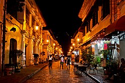
Located on the western coast of the large island of Luzon, facing the South China Sea, it is a UNESCO World Heritage Site[7] and it is one of the few Spanish colonial towns left in the Philippines whose old structures have mostly remained intact. It is well known for its sett pavements and a unique architecture of the Spanish Philippines colonial era which fuses native Philippine and Oriental building designs and construction, with colonial Spanish architecture that is still abundant in the area, mainly the bahay na bato houses and an Earthquake Baroque church.
It is known as the birthplace of Elpidio Quirino, the 6thPresident of the Philippines. He was born at the former location of the Provincial Jail (his father was a warden).[8] He also resided in the Syquia Mansion, which is a wedding gift of his in-laws to his wife.[8]
The origin of the name "Vigan" is pre-colonial. It was also spelled "Bigan" in Spanish colonial records (including in the 1734 Velarde map). It is derived from Ilocanobigàan (or kabigàan), literally "the place where bíga abounds". Bíga is the common name of the giant taro (Alocasiamacrorrhizos) in Ilocano.[10][11]
The meaning of "Vigan" is also a common subject of folk etymologies, of which there are two popular accounts. One claiming it originated from a misunderstood question (a common trope in Filipino place-name folk etymologies); and another which claims it came from Chinese bí-gān (美岸), meaning "beautiful shore" (allegedly from the gold dust in the seashore). Neither of these accounts have historical or academic evidence.[12][13]
Other names
The trading town of Vigan was near the settlement founded by Salcedo, which he named Villa Fernandina ("Town of Ferdinand"), in honor of Prince Ferdinand, the firstborn son of King Philip II of Spain. Villa Fernandina was originally meant to be the capital of Salcedo's encomienda, but it suffered from outbreaks of disease early in its history. It was later merged with the bigger trading town of Vigan, and was administered by a single alcalde mayor. Eventually, the name of Villa Fernandina became attached to Vigan.[12][14] As the city grew, and the seat of the Archdiocese of Nueva Segovia transferred to Vigan, it was later renamed Ciudad Fernandina de Vigan ("Ferdinand's City of Vigan/Fernandine City of Vigan").
History
Aerial view of Vigan, circa 1940s
Pre-Colonial Era
Due to silting of the Mestizo River, Vigan is no longer separated from the mainland, therefore no longer an island. The city is unique in the Philippines because it is one of many extensive surviving Philippine historic cities, dating back to the 16th century.
During the pre-colonial period, Vigan was a coastal trading post frequented by trade ships of Austronesian, Arab, Indian, Chinese, and (mainly) Japanese traders (similar to other trading towns along the Ilocos region like Aparri, Candon, and Lingayen).[15] Traders sailing from the South China Sea came to Isla de Vigan (Island of Vigan) via the Mestizo River that surrounded it.
Spanish Colonial Era
In the book The Philippine Island (Vol. III, p.276, Blair and Robertson) two letters from Governor-GeneralGuido de Lavezaris to King Philip II of Spain mention: "It seemed best to send Captain Juan de Salcedo with 70 or 80 soldiers to explore the coast of Los Ilocanos on the shores of the river called Bigan." The Spaniards led by Salcedo marched north from Manila on May 20, 1572. They arrived in Vigan on June 13, 1572.[16]
Villa Fernandina de Vigan
Thus, after the successful expedition and the exploration of the North, Juan de Salcedo founded "Villa Fernandina de Vigan" in honor of King Philip II's son, Prince Ferdinand, who died at the age of four. From Vigan, Salcedo rounded the tip of Luzón and proceeded to pacify Camarines, Albay, and Catanduanes. As a reward for his services to the King of Spain, Salcedo was awarded the old province of Ilocos, which consisted of the modern provinces of Ilocos Norte, Ilocos Sur, Abra, La Union and part of Mountain Province as his hacienda (estate), and was accorded the title of Justicia Mayor de esta Provincia de Ylocos (Province Mayor of Ilocos).[17][18]
In 1574, Salcedo returned to the capital of his encomienda (trusteeship), Vigan, bringing with him his soldiers and some Augustinian missionaries to pioneer the evangelization of the Ilocos region. He established a Spanish city for the purpose of controlling the neighboring country.
Governor General Gómez Pérez Dasmariñas, in his account of encomienda dated in Manila on May 31, 1591, states: "The town of Vigan called Villa Fernandina consisted of Spanish settlers; a priest; a Justice Alcalde Mayor (Governor); and a Deputy. The King collects 800 tributes (equivalent to 3,200 subjects)." During this period, Vigan was composed of 19 barrios (districts).
Between 1645 and 1660, Vigan was divided into 21 Cabezas de Barrio (Town Mayors) as mentioned in the Libro de Casamiento (Book of Marriage); from the records of the parish house of Vigan found in its archives. Separated from the indigenous population, the Chinese migrants were residents in a neighbourhood called El Pariancillo, los Sangleyes del parian (The Sangleyes of the Parian); and the Spanish settlers were residents in a town called Los Españoles de la Villa (The Town Spaniards). The Spaniards consisted of about 60 Spanish Households.[19] The region of Ilocos where Vigan is located is also recorded to have had 631 mixed Spanish-Filipino families.[20]:31 It also had 44,852 native families.[20]:31
Ciudad Fernandina de Vigan
In 1755, Bp. Juan de la Fuente Yepes made a request to the King Fernando VI to move the Diocese of Nueva Segovia to Villa Fernandina due to the deteriorating status of Lal-lo in Cagayan. In 1758, with the Royal Decree signed by Fernando VI, Villa Fernadina became Ciudad Fernandina de Vigan and the See of Nueva Segovia was transferred from Lal-lo. The bell ensconced within the belfry of Vigan, has the imprinted words of the decree. Wherever the clang of the bell reaches, it marks the territory of Ciudad Fernandina de Vigan. In 1849, Leona Florentino, the mother of Philippine women's literature, was born in Vigan.[21]
Philippine Revolution and American Occupation
During the Philippine Revolution, revolutionary forces under Manuel Tinio, supported by the Ilocano rebels, attacked and defeated the Spanish colonial forces and captured the city in the Siege of Vigan.[22] During the Philippine–American War, American forces led by Commander McCracken and Lt. Col. James Parker occupied the town in November 1899.[23]
In 1999, Vigan was listed by UNESCO as the best preserved example of Spanish colonial towns in Asia.[24] Its architecture is the conglomeration of cultural elements from the Philippines, China, and Spain, making it unique in the world.
On December 27, 2000, then PresidentJoseph Estrada signed Republic Act No. 8988, that "revalidated and recognized" Vigan's city status granted by virtue of the Royal Decree of September 7, 1757, issued by Ferdinand VI, King of Spain.[25] This legislation serves as Vigan's present city charter. The charter did not provide a clause for a plebiscite and the law took effect in January 21, 2001.
On July 27, 2022, a 7.0 magnitude earthquake struck parts of Luzon,[26] damaging the city's UNESCO World Heritage sites including the Vigan Cathedral and old-century houses, as well as few power lines toppled along Calle Crisologo.[27]
Geography
Vigan coast
The City of Vigan is situated in the northern part of Luzon, the Philippines’ largest island. It serves as the capital of Ilocos Sur and has been a major political and trading center since before the Spanish colonizers arrived in the Philippines.
Vigan is situated 403.88 kilometres (250.96mi) from the capital city of Manila.
Topography
Its 2,511 hectares (6,200 acres) of land consists mostly of plains with gentle hills. Its boundaries on the north, east, south, and west are the municipalities of Bantay, Santa, Caoayan, and Santa Catalina, respectively. The South China Sea is on its southwest portion.
Majority of its land, 60 percent of it, is used for agriculture. Around 32 percent is made up of residential area, nearly three percent are for commercial and industrial use, and around one percent is for institutional purposes. There are also forest reserves and fishponds included in Vigan's land area.
Vigan is made up of 39 barangays. Thirty of them are classified as rural, but they occupy only 2,366 hectares. The remaining nine are classified as poblacion barangays and are together 144.75 hectares big.
The barangays of Pagburnayan, Paoa, and Tamag are on the area of rolling plains. On the other hand, portions of Barangays Tamag and the barangays of Bulala and Salindeg are found on the city's hilly parts.
Its most dominant hill feature is the Vigan Gap Hill in the eastern part, just 10 kilometers away from the city. Vigan used to be separated from the rest of the mainland by the rivers of Abra, Mestizo and Govantes, making it an island during that time. The Govantes River cuts the current Vigan plain from North to South.
The large Abra and Mestizo rivers, together with the rivers of Bantay, Bantaoay, Nauman and Santo Tomas serve as part of a network that drain the Vigan plains. These rivers are not only important in safekeeping the city from floods, they also served as important ways of transport for trade-related activities from the 15th century to the 19th century, that helped make Vigan a thriving center. The most vital of these rivers is said to be the Mestizo River which was used by the small vessels to transport goods and people.
There is a faulting trend in the Vigan plain that ends in Santa Catalina.
Soil type
The land area of Vigan is generally flat. Slopes of 20 are found at Barangay V, Tamag, and Paoa. There are no forest reserves in the city in terms of potential and raw materials. Bamboo is the only forest product in Vigan.
There are five soil types in the city. First, the Bantay Loam, located at the southern portion of Raois, has a land area of 36.67 hectares, and is good as pastureland. The second, Umingan sandy, with a land area of 1191.57 hectares, is good for upland rice and vegetables. The third, San Manuel clay loam, which is best for bananas, cotton and vegetables, has an area of 1244.57 hectares. The fourth, Bantog clay—considered as the most significant type for soil, and the best clay material for making pots, jars and all earthenware, has a land area of 31.65 hectares. The fifth, beach sand, with a land area of 7.28 hectares, is generally found on the shores of all the beaches of Vigan, and is best for coconut plantation.
Barangays
Political Subdivisions of Vigan City
Vigan is politically subdivided into 39 barangays.[28] Each barangay consists of puroks and some have sitios.
The sedimentary and metamorphic rocks that are present in the city are alluvium, fluviatile, lacustrine, paludal and beach deposits such as coral, stools, and beach rock. These are predominantly found along the coastal areas of Vigan. An important non-metallic mineral resource found in Vigan is the kind of clay that is used in making earthen jars locally called burnay. Earthenware of different uses and sizes are made of this kind of clay. Known as Bantog clay, the mineral is the basic material in making bricks. These bricks are the original materials in building the Hispanic houses of Vigan.
Physiography
Vigan is situated in a Quaternary Age sedimentary plain called the Vigan-Bantay Plain which is part of the Ilocos coastal plain. The Vigan-Bantay Plain is bounded on the east by a moderately rugged Miocene sediments consisting of interbedded sandstones and shale to very rugged Meta-volcanics and Meta sediment topography; on the south is the Municipality of Santa where the north–south trending fault terminates; to the west is the South China Sea; while the northern boundary opens to the northern extension of the Ilocos coastal plain.
The central part of the plain is characterized by a dissected ridge of Plio-Pleistocene age that trends in a northeast–southwest direction. The ridge divides the Vigan-Bantay Plain into northern and southern plains.
The northern part of the plain is drained by minor rivers namely: Bantaoay, Santo Tomas, and Nauman rivers, while the Abra River is the main drainage network of the southern portion of the plain. The Abra River meanders into the hinterland but exhibits a braided pattern across the plain.
The drainage network of the eastern margin of Vigan-Bantay plain consist of deeply cut valleys whose pattern is strongly controlled by main faulting trends, particularly those in the northerly and easterly directions.
Vigan is being drained by the Vigan River and Bantay River, respectively, on the north and on the south by Mestizo River whose water discharge comes from the Bantaoay head waters.
The relief of the Vigan-Bantay plain is actively level to undulating with a slope ranging from 0% to 8%. Vigan in particular is generally in level with several hills in Barangays Tamag, Bulala, and Salindeg, sometimes reaching about 50 meters in elevation and has a slope ranging from 3% to 8%.
The eastern margin of the plain characterized by a steep to very steep slope, about 40% to 60%, the relief often reaches an elevation of more than 600 meters especially the northerly and easterly portion.
The dominant topographic feature in the eastern margin of the town is the Vigan Gap Hill where the continuously shifting Vigan River cuts its way. The Gap Hill is located approximately 10 kilometers east of Vigan.
Weather and climate
Climate data for Vigan (1991–2020, extremes 1903–2023)
The city of Vigan falls under tropical savanna, which is characterized by two pronounced seasons – the dry season which starts from the month of November and ends in April; and the wet season which spans the months of May to October. The average annual rainfall is 2,506 millimetres (98.66in) and the heaviest registered rainfall is 6,933 millimetres (272.95in).
The average temperature is 26°C. The average warmest temperature is 30.9°C and the average coldest temperature is 21.1°C. An average of 7-10 typhoons visit Vigan annually. The average relative humidity is 81%.
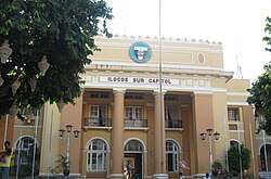
Vigan is part of the first congressional district of the province of Ilocos Sur. It is governed by a mayor, designated as its local chief executive, and by a city council as its legislative body in accordance with the Local Government Code. The mayor, vice mayor, and the councilors are elected directly by the people through an election which is being held every three years.
Elected officials
Position
Name
District Representative (1st Legislative District the Province of Ilocos Sur)
When Juan de Salcedo founded Vigan in 1572, he decided to pattern its urban plan with that of Intramuros, the walled city in Manila.
The urban planners of the Spanish government also followed a basic pattern that can be observed in most old towns in the country, whose establishment dates back to the Spanish colonial period. This pattern is detailed in the Ley de las Indias, the Law of the Indies, and was put into force in the 18th century. Under the Law of the Indies streets were to follow a grid pattern, the center of which being a plaza or central park.
In Vigan, the central park is the Plaza Salcedo. Next to it are the administrative buildings—the Casa Real or provincial administrative office, and the municipio (municipal hall). A stone's throw away are the religious buildings—the seminary of the archdiocese, the Arzobispado (Archbishop's Palace), and the St. Paul's Cathedral. Beside these religious structures is the church-run school, the Saint Paul College, known in its early days as the Colegio de Niñas. After the full transfer of the said school to the neighboring towns of Bantay and San Vicente, the building was handed over to the Archdiocese of Nueva Segovia and is currently being occupied by a retail store chain, with only a commemorative plaque at the building's entrance and the old "ROSARY COLLEGE" concrete sign at its rear reminding visitors of its past (the school's old logo, once found at the building's facade, has been removed sometime later).
Ilocos Sur Provincial Hospital - Gabriela Silang at Barangay Tamag
A unique thing is the existence of another plaza, the Plaza Burgos, which is immediately beside the St. Paul's Cathedral. After the first tier emanating from Plaza Salcedo are the houses of prominent residents that now make up the preserved heritage houses of Vigan. This urban plan remained relatively intact despite wars and natural calamities that have been endured by Vigan since its foundation.
The major changes to the original urban landscape were caused by fires. The Casa Real was replaced with a provincial capitol building during the American period when the original structure burned down. The archdiocese seminary was also destroyed by fire in 1968, and it lay in ruins until the late 1990s, when part of a shopping mall was built on the site.
The residential areas were likewise not spared. Some of the houses on Crisologo Street were casualties of fire during the Japanese period; several houses on Quezon Avenue were destroyed by fire in 1952; while in 1971, some houses near Plaza Burgos burned down as well. The houses along Crisologo Street that were burned were later reconstructed faithfully following the architecture of the former structures.
Presently, there are other major areas of activities other than the two plazas, though these are still where most recreation and shopping are done. One may also go to the southern part of the city to reach the commercial area and public market. The current public market is a new one, as the old one (formerly the Imelda Socio-Commercial Complex), on the same site, was (also) destroyed by fire. A new mall (opened in December 2017) was constructed on the site of the city's first Public Market, found in the center of the business district, after being the site of some business establishments and a tricycle-for-hire terminal.
Mayor Jose 'Bonito' Singson, Jr. led the 2024 Grand Parade of Vigan City Fiesta and Vigan Longganisa Festival. The 2024 Fiesta featured Banaoang Marathon, a 12-kilometer track from Banaoang Bridge from Santa, Ilocos Sur and Bantay, Ilocos Sur boundary to the Plaza Burgos, Vigan, LGBTQIA+ Day, Vigan Conservation Complex symposium, Community Alay Gupit, Got Talent and fashion show, Vigan Food Festival, Search for Miss Vigan, Dog and Cat Fun Day, Longganisa Street Dance Showdown, Pinaka-Livestock contest, Education Day, and Social Services Night. On January 22, 2024, Vigan launched '101 Ways to Cook Longganisa' cookbook for the January 18–27, 2024 Longganisa Festival.[52][53]
Transportation
Calesa, one of the modes of transportation in Vigan
Metro transport
Modes of transport within the city are purely land-based. Vehicles for public use include jeepneys, tricycles, vans-for-hire (or PUVs/public utility vehicles) and calesas (horse-drawn vehicles). Buses, mini-buses and jeepneys provide transportation to and from Vigan. The metro Vigan transport system is mostly served by tricycles, which are color- and number-coded to identify their municipality of origin.
Land transportation
Vigan City is well-served by a network of roads and a major highway that connects to Manila North Road, the highway leading to Manila and the rest of the country. Major bus companies such as Dominion Bus Lines, Viron Transit, Partas, and Aniceto/St. Joseph operate terminals in Vigan. GMW Florida Transport operates a terminal in Bantay, just outside Vigan. Bus companies such as Maria de Leon and Fariñas pass by Vigan on their way to Laoag. They operate direct and/or indirect bus services from Vigan City to points in Luzon, mostly to Manila, Baguio, and Laoag and vice versa. There are also independent bus operators, who recently banded together to form different transport cooperatives,[54] plying the Laoag-Vigan-Carmen and Vigan-Abra routes, and have a joint terminal found at the New Vigan Public Market Annex. A taxi service started operating in 2019, just before the COViD-19 pandemic struck.
Air transportation
A secondary airport called Vigan Airport (also known as Mindoro Airport) is located at Barangay Mindoro. It has one asphalted runway, 900 meters long and 30 meters wide. The airport was once a dormant asset of the city for it does not generate revenue, with only chartered and private planes using it; it is currently being upgraded and is on its way toward commercialization.
Education
The Vigan City Schools Division Office oversees the operations of all Schools District Offices within the city. The Division Office is managed by the Department of Education (DepEd). There are two schools district offices (SDOs), namely: Vigan City District I Schools District Office, and Vigan City District II Schools District Office. They govern the operations of all private and public elementary and high schools throughout the city.[55] Technical and vocational schools are governed by TESDA. Tertiary levels are governed by CHED.
Primary and elementary schools
Adventist School La Ciudad Fernandina
Ayusan-Paoa Elementary School
Bulala-Paratong Elementary School
Burgos Memorial School East
Burgos Memorial School West
Cabaroan-Cabalangegan Elementary School
Calvary Baptist Academy (Elementary)
Camangaan Elementary School
Capangpangan Elementary School
Dudley-S Lara Educational Center for Children
Gov. Evaristo Singson II Memorial Elementary School
Jose Singson Elementary School
Mindoro Elementary School
Mother Edeltraud Danner School
Nagsangalan Elementary School
Pantay Elementary School
Raois Elementary School
Rugsuanan-Puroc Elementary School
Salindeg Elementary School (Salindeg-Pong-ol, Barraca Elementary School)
San Julian Elementary School
St. Thomas Aquinas Learning Center
Tamag Elementary School
UCCP Christian Learning and Development Center
Vigan Central School
Vigan Nan Chong School
Secondary schools
Calvary Baptist Academy
Ilocos Sur National High School (ISNHS) — the major national high school in the province.
Immaculate Conception Minor Seminary
Lyceum de Ylocos (Senior High School)
Marian Institute of Vigan
Vigan East National High School
Vigan West National High School
Technical and vocational school
Lyceum de Ylocos — is a new school offering Technical-Vocational courses and is a registered Senior High School offering various Tracks that include ABM, GAS, HUMSS and TLE-Technical-Vocational Courses. Situated at the heart of the Heritage City, 3F Vigan Landmark Building, Barangay VIII. The school adopted a classical name to emphasize the grandeur of its location, the Heritage City of Vigan, the only awardee of the title New World Wonder City in the Philippines. It fosters the promotion of tourism and hospitality; promotes preservation of the cultural heritage and innovates towards service delivery and business processing. Lyceum de Ylocos is committed to be of service to students through the provisions of an environment where there would be opportunities to relate theories and knowledge to practical training.
Higher educational institutions
Data Center Colleges Philippines Vigan Branch - Data Center Philippines (DCPI) first came to Ilocos Sur through a partnership with the University of Northern Philippines for its computerization efforts in the late 80s. It later evolved independently as a college offering computer- and non-computer-related courses. Formerly operating where Lyceum de Ylocos is operating today, they are currently located in a building just outside UNP's Vigan Campus.
Macro Colleges — the first computer college in the province, having evolved from being the first shop in Ilocos Sur to offer computer-based services. The school is now K-to-12 College, located at Quezon Avenue. Currently operated by the Nueva Segovia Consortium of Cooperatives.
STI College
University of Northern Philippines Main Campus — in Barangay Tamag. It is the oldest state university in Northern Luzon, founded by virtue of Republic Act 4449, authored by Congressman Floro Crisologo.
Leona Florentino, a Filipina foundational poet, dramatist, satirist, and playwright who is also known as the Mother of Philippine Women's Literature and honored in France, Spain, and the United States.[21]
Marcelino Crisólogo, politician, poet, writer and playwright. Calle Crisologo or Mena Crisologo Street was named after him.
Isabelo de los Reyes, patriot, politician, writer, journalist, and labor activist.
Leona Florentino, poet, dramatist, and playwright; recognized as the "mother of Philippine women's literature".
Deogracias Victor B. Savellano, former governor, former Vice Governor, former House of Representatives Undersecretary for Livestock at the Department of Agriculture and former Mayor of Cabugao
↑Blench, Roger M. (2012). "Vernacular Names for Taro in the Indo-Pacific Region: Implications for Centres of Diversification and Spread". Senri Ethnological Studies. 78: 21–43. doi:10.15021/00002508.
12Azurin, Arnold M. (1998). "Vintage Vigan". In Apilado, Digna B. (ed.). History of the People: Volume 1 (Abra, Ilocos, Ilocos Sur, La Union and Pangasinan). National Historical Institute. pp.36–43.
↑"Jesuits In The Philippines (1581-1768)" Page 59 "These settlements were much smaller than Manila. In 1582 Manila had an adult male population of 300 Spaniards; Vigan, 60; Nueva Caceres, 30; Cebu, 70; Arevalo, 20. In 1586 Manila had 329 Spanish men and youths capable of bearing arms; the most recently established settlement, Nueva Segovia in Cagayan, had 97; Nueva Caceres, 69; Arevalo, 65; Cavite, 64; Cebu, 63; Villa Fernandina, 19.
This page is based on this Wikipedia article Text is available under the CC BY-SA 4.0 license; additional terms may apply. Images, videos and audio are available under their respective licenses.