Surigao del Sur

Last updated

Surigao del Sur
Province of Surigao del Sur
Tinuy-an Falls.jpg
Cagwait White Beach.jpg
Wellenreiten.jpg
Hinatuan enchanted river.jpg
Britania Is.jpg
Surigao del Sur Provincial Capitol.JPG
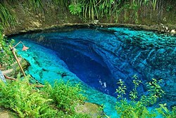
(from top: left to right) Tinuy-an Falls in Bislig, White beach in Cagwait, surfer in beach of Lanuza, Hinatuan River, Britania Islands and Surigao del Sur Provincial Capitol.
Surigao del Sur Flag.png
Provincial seal of Surigao del Sur, Philippines.png
Nickname: 
Shangri-La by the Pacific [1]
Surigao del Sur in Philippines.svg
Location in the Philippines
OpenStreetMap
Surigao del Sur
Coordinates: 8°40′N126°00′E / 8.67°N 126°E / 8.67; 126
Country Philippines
Region Caraga
Founded June 19, 1960
Capital Tandag
Largest city Bislig
Government
  Type Sangguniang Panlalawigan
   Governor Alexander T. Pimentel (PDP–Laban)
   Vice Governor Manuel O. Alameda (Hugpong Surigao Sur)
  Legislature Surigao del Sur Provincial Board
Area
[2]
  Total4,932.70 km2 (1,904.53 sq mi)
  Rank21st out of 81
Highest elevation611 m (2,005 ft)
Population
 (2020 census) [3]
  Total642,255
  Rank47th out of 81
  Density130/km2 (340/sq mi)
   Rank66th out of 81
Divisions
   Independent cities 0
   Component cities
   Municipalities
   Barangays 309
   Districts Legislative districts of Surigao del Sur
Time zone UTC+8 (PHT)
ZIP code
8300–8318
IDD : area code +63(0)86
ISO 3166 code PH-SUR
Spoken languages
Income classification1st class
Website www.surigaodelsur.gov.ph

Surigao del Sur (Surigaonon: Probinsya nan Surigao del Sur; Cebuano : Habagatang Surigao; Tagalog : Timog Surigao), officially the Province of Surigao del Sur, is a province in the Philippines located in the Caraga region in Mindanao. Its capital is Tandag City. Surigao del Sur is situated at the eastern coast of Mindanao and faces the Philippine Sea to the east.

Contents

Etymology

There are two hypotheses on the original meaning of "Surigao" among linguists, depending on the original root word. If the root word was taken to be sulig ("sprout" or "spring up"), then Surigao may have derived from suligao ("spring water"), likely referring to the Surigao River (known as "Suligaw" in Mandaya) that empties at the northern tip of the island of Mindanao. [4] [5] Early historical accounts record the name of the river as Suligao, Surigao, or Zurigan. [6]

Another possibility is that it is derived from Visayan surogao or suyogao, meaning "water current". From suyog (also sulog or surog), "current"; cf. Sinulog, Sulu, and Tausug (Suluk). [7]

History

An old map showing the current territories of the province as part of the historical province of Surigao Surigao province map 1918.JPG
An old map showing the current territories of the province as part of the historical province of Surigao

Early history

In precolonial times, the region of Surigao was inhabited by the Visayan Surigaonon people in the coastal areas, as well as Lumad groups in the interiors like the Mandaya, Mansaka, Mamanwa and Manobo. [8]

Spanish colonial era

During the Spanish Occupation in 1860, six military districts were created in Mindanao, with Surigao and Agusan forming the "East District". In 1870, the district was renamed to "Distrito de Surigao".

American invasion era

In 1901, Distrito de Surigao became chartered province. Agusan became an independent province in 1907 during the American era, when it was separated from Surigao. [8]

Philippine independence

Foundation

Surigao del Sur was created as the 56th Philippine province on June 19, 1960, through Republic Act 2786, separated from its mother province, Surigao, on September 18, 1960. [9]

At the time of its inception, it was classified as 4th Class province with an annual income of over 300,000.00. Seven years later, because of rapid increase of revenue collection particularly from the logging ventures, it has been reclassified as Ist Class B and in 1980 as Ist Class A with an estimated annual income of around 13,000,000. It has been reclassified as 2nd Class with a revenue adding up to 315,888,300.63.[ citation needed ]

Recaredo B. Castillo was the appointed first governor and subsequently elected governor while Vicente L. Pimentel was the first elected congressman.

The province was formed with 13 municipalities. Six more were added, raising the number to 19 with Tandag as the capital. Two of its municipalities have been elevated to cities; the first was Bislig City.

Contemporary

In 2007, Tandag was granted cityhood but it was nullified via a controversial decision by the Supreme Court a year later. In 2009, Tandag got back its city status after the court reversed its own ruling on December 22, 2009.

House Bill No. 2336 of the 19th Congress seeks to separate the southern part of the province to be formed as the new Province of Surigao Oriental.

Geography

Tandag Airport Aeroporto di Tandag esterno.jpg
Tandag Airport

Surigao del Sur is located along the northeastern coast of Mindanao facing the Philippine Sea between 125°40' to 126°20' east longitudes and 7°55' and 9°20' north latitudes. It is bounded on the northwest by the province of Surigao del Norte, on the southeast by Davao Oriental, on the west and southwest by Agusan del Norte and Agusan del Sur.

Situated west is the Diwata Mountain Range, isolating the province from the rest of Mindanao. To the east lies the Philippine Sea. The Mindanao Deep, one of the deepest trenches in the world, is situated a few kilometers east of the coastline. [10] [8]

Land area

Ricefield in Cantilan Cantilan Rice Field 1.JPG
Ricefield in Cantilan

The land area of the province is 4,932.70 square kilometres (1,904.53 sq mi) [11] representing 27.75 percent of the total land area of Caraga Administrative Region and about 5.14 percent and 1.74 percent of the total land area of Mindanao and Philippines, respectively. The province is elongated in shape, extending from the northeastern portion at Carrascal to the southernmost municipality of Lingig. It is approximately 300 kilometres (190 mi) in length and 50 kilometres (31 mi) at its widest point which runs from Cagwait to San Miguel.

Municipal-wise, San Miguel has the biggest land area accounting for

Of the 5,230.50 square kilometres (2,019.51 sq mi) land, only 1,703.72 square kilometres (657.81 sq mi) or 32.22 percent are classified as alienable and disposable (A and D) while 3,583.523 square kilometres (1,383.606 sq mi) or 67.78 percent are forest land. Tagbina has the biggest share of alienable and disposable land with 234.21 square kilometres (90.43 sq mi) or about 56.51 percent of its land area followed by Hinatuan with 202.52 square kilometres (78.19 sq mi) or 63.56 percent of its land area.[ citation needed ]

The Britania Group of Islands Britania Is.jpg
The Britania Group of Islands

Of the 3,583.523 square kilometres (1,383.606 sq mi) of forest land, 636.076 square kilometres (245.590 sq mi) are protection forest, 2,582.43 square kilometres (997.08 sq mi) production forest, 12.68 square kilometres (4.90 sq mi) are non-forest agriculture and 352.337 square kilometres (136.038 sq mi) are for non-forest mining. As of today, the province still has vast areas of remaining old growth and mossy forest.[ citation needed ]

Climate

The province falls under Type II climate of the Philippines, characterized by rainfall distributed throughout the year, although there is a distinct rainy season which begins from the month of November and ends in March. However, the climatic behavior of the province for the past few years has shown variations wherein the onset of the rainy seasons no longer occurs on the usual time. Months with low rainfall are from July to October with September as the driest month. Wet months are from November to June with January as the wettest month.

Surigao del Sur is one of the top 20 most vulnerable provinces to climate change in the Philippines. [12]

Climate data for Surigao del Sur
MonthJanFebMarAprMayJunJulAugSepOctNovDecYear
Mean daily maximum °C (°F)29.6
(85.3)
30.0
(86.0)
30.8
(87.4)
31.6
(88.9)
32.0
(89.6)
32.2
(90.0)
32.3
(90.1)
32.5
(90.5)
32.5
(90.5)
32.2
(90.0)
31.2
(88.2)
30.6
(87.1)
31.5
(88.6)
Mean daily minimum °C (°F)23.4
(74.1)
23.2
(73.8)
23.6
(74.5)
24.2
(75.6)
24.4
(75.9)
24.3
(75.7)
24.1
(75.4)
24.3
(75.7)
24.1
(75.4)
24.0
(75.2)
23.9
(75.0)
23.7
(74.7)
23.9
(75.1)
Average rainy days242120191616141413171721212
Source: Storm247 [13]

Administrative divisions

Surigao del Sur comprises 17 municipalities and two cities, further subdivided into 309 barangays. There are two congressional districts encompassing all cities and towns.

Political divisions Ph fil surigao del sur.png
Political divisions
  •   Provincial capital and component city
  •   Component city
  •  Municipality

Demographics

Population census of Surigao del Sur
YearPop.±% p.a.
1903 42,346    
1918 55,421+1.81%
1939 99,981+2.85%
1948 109,949+1.06%
1960 165,016+3.44%
1970 258,680+4.59%
1975 302,305+3.17%
1980 377,647+4.55%
1990 452,098+1.82%
1995 471,263+0.78%
2000 501,808+1.36%
2007 545,902+1.17%
2010 561,219+1.01%
2015 592,250+1.03%
2020 642,255+1.61%
Source: Philippine Statistics Authority [14] [15] [16]

The population of Surigao del Sur in the 2020 census was 642,255 people, [3] with a density of 130 inhabitants per square kilometre or 340 inhabitants per square mile.

The province is home to the Kamayo and Agusan people. Their dances are showcased in the local festival, "Sirong Festival", held especially during the town fiesta of Cantilan. The Sirong Festival depicts the early Christianization of the early Cantilan inhabitants where the natives tried to defend their land against Visayan invaders.

The indigenous people of the province were largely Christianized during the early times of the Spanish conquest.

Languages

The Surigaonon and Tandaganon languages are spoken in most parts of Surigao del Sur (except in Bislig and the towns of Barobo, Hinatuan, Lingig and Tagbina, where most of the inhabitants speak Cebuano and their native Kamayo, a different language but one distantly related to Surigaonon, is spoken by the rest of the population), with the Cantilangnon dialect, a northern variety of Surigaonon that is very much similar to the dialect of Surigaonon as spoken in Surigao del Norte, being spoken mostly in the five northern municipalities of the province, namely Carrascal, Cantilan, Madrid, Carmen and Lanuza (or the municipal cluster called Carcanmadcarlan); these municipalities were once under a single Municipality of Cantilan before December 10, 1918.

Tagalog and English are also widely spoken throughout the province and used as the primary languages of education, business, and administration.

Economy

Coastal fishing in Cantilan Cantilan Coast Fishing.JPG
Coastal fishing in Cantilan

Surigao del Sur is one of the suppliers of rice, bananas and other tropical fruits. Copper, chromite and silver are also found here. Marine and aquaculture are abundant in the province, being primary livelihoods of the inhabitants as the province is well known for producing seafood and sea by-products.

Mineral resources

Surigao del Sur is endowed with metallic minerals such as copper, gold, chromite, cobalt, nickel and lead zinc, as well as non-metallic (limestone, coal and feldspar, clay diatomite/bentomite and coarse/fine aggregates). There are small and large scale mining activities in the province. Corporations operating in a large scale are the Marc Ventures Mining Development Corporation at Carrascal and Cantilan, operating in an area of 4,799 hectares (47.99 km2) within the Diwata Mountain Range. [23] [24] The [TP Construction and Mining Corporation, also in Carrascal, focuses on gold and nickel mining in an area of 35.64 square kilometres (13.76 sq mi) and 48.6916 square kilometres (18.80 sq mi), respectively. The Carac-an Development Corporation, also in Carrascal, has an area of 506.3764 square kilometres (195.51 sq mi). Small scale mining activities are found in the municipalities of Barobo, Carmen and San Miguel.

Tourism

Bislig's main tourist attraction is the Tinuy-an Falls, [25] known as the little "Niagara Falls of the Philippines". It is a white water curtain that flows in three levels about 55 metres (180 ft) high and 95 metres (312 ft) wide. [26] Its unique natural formation once appeared in the International Travel Magazine. It is also known as the widest waterfall in the Philippines.[ citation needed ]

Surfing in Surigao del Sur is widely known and has been one of the local tourist attractions. This extreme sport is often practiced in Cantilan and Lanuza. [27] Skimboarding is also found in several municipalities, attracting tourists.

See also

Related Research Articles

<span class="mw-page-title-main">Agusan del Norte</span> Province in Caraga, Philippines

Agusan del Norte, officially the Province of Agusan del Norte, is a province in the Caraga region of the Philippines. Its capital is the city of Cabadbaran with several government offices located in the highly-urbanized city of Butuan. It is bordered on the northwest by Butuan Bay; northeast by Surigao del Norte; mid-east by Surigao del Sur; southeast by Agusan del Sur, and southwest by Misamis Oriental.

<span class="mw-page-title-main">Agusan del Sur</span> Province in Caraga, Philippines

Agusan del Sur, officially the Province of Agusan del Sur, is a province in Caraga region, Mindanao, Philippines. Its capital is the municipality of Prosperidad. It is bordered on the northwest by Agusan del Norte and Misamis Oriental; east by Surigao del Sur; southeast by Davao Oriental; mid-south by Davao de Oro; southwest by Davao del Norte and, mid-west by Bukidnon. It is the fourth largest province in the country in terms of area, with the size of 3,856 sq miles.

<span class="mw-page-title-main">Surigao del Norte</span> Province in Caraga, Philippines

Surigao del Norte, officially the Province of Surigao del Norte, is a province in the Philippines located in the Caraga region of Mindanao. The province was formerly under the jurisdiction of Region 10 until 1995. Its capital is Surigao City. The province comprises two major islands—Siargao and Bucas Grande—in the Philippine Sea, plus a small area at the northeastern tip of mainland Mindanao and other surrounding minor islands and islets. This mainland portion borders Agusan del Norte – between the Municipality of Alegria in Surigao del Norte and the Municipality of Kitcharao in Agusan del Norte; and the province of Surigao del Sur, to the south.

<span class="mw-page-title-main">Caraga</span> Administrative region of the Philippines

Caraga, officially the Caraga Administrative Region and designated as Region XIII, is an administrative region in the Philippines occupying the northeastern section of Mindanao. The region was created through Republic Act No. 7901 on February 23, 1995. The region comprises five provinces: Agusan del Norte, Agusan del Sur, Dinagat Islands, Surigao del Norte, and Surigao del Sur; six cities: Bayugan, Bislig, Butuan, Cabadbaran, Surigao and Tandag; 67 municipalities and 1,311 barangays. Butuan, the most urbanized city in Caraga, serves as the regional administrative center.

<span class="mw-page-title-main">Tandag</span> Capital of Surigao del Sur, Philippines

Tandag, officially the City of Tandag, is a 5th class component city and capital of the province of Surigao del Sur, Philippines. According to the 2020 census, it has a population of 62,669 people.

<span class="mw-page-title-main">Mainit</span> Municipality in Surigao del Norte, Philippines

Mainit, officially the Municipality of Mainit, is a 4th class municipality in the province of Surigao del Norte, Philippines. According to the 2020 census, it has a population of 28,019 people.

<span class="mw-page-title-main">Sibagat</span> Municipality in Agusan del Sur, Philippines

Sibagat, officially the Municipality of Sibagat, is a 1st class municipality in the province of Agusan del Sur, Philippines. According to the 2020 census, it has a population of 33,957 people.

<span class="mw-page-title-main">Bislig</span> Component city in Surigao del Sur, Philippines

Bislig, officially the City of Bislig, is a 3rd class component city in the province of Surigao del Sur, Philippines. According to the 2020 census, it has a population of 99,290 people.

<span class="mw-page-title-main">Surigaonon language</span> Austronesian language of the Philippines

Surigaonon is an Austronesian language spoken by Surigaonon people. As a regional Philippine language, it is spoken in the province of Surigao del Norte, Dinagat Islands, Surigao del Sur, and some portions of Agusan del Norte, especially the towns near Lake Mainit, Agusan del Sur and Davao Oriental.

<span class="mw-page-title-main">Cantilan</span> Municipality in Surigao del Sur, Philippines

Cantilan, officially the Municipality of Cantilan, is a 2nd class municipality in the province of Surigao del Sur, Philippines. According to the 2020 census, it has a population of 34,060 people.

<span class="mw-page-title-main">Lanuza, Surigao del Sur</span> Municipality in Surigao del Sur, Philippines

Lanuza, officially the Municipality of Lanuza, is a 4th class municipality in the province of Surigao del Sur, Philippines. According to the 2020 census, it has a population of 13,642 people.

<span class="mw-page-title-main">La Paz, Agusan del Sur</span> Municipality in Agusan del Sur, Philippines

La Paz, officially the Municipality of La Paz, is a municipality in the province of Agusan del Sur in the Caraga of the Philippines. The population was 30,969 at the 2020 census. La Paz is the largest town in terms of land area in Agusan del Sur and the entire Mindanao.

<span class="mw-page-title-main">San Francisco, Agusan del Sur</span> Municipality in Agusan del Sur, Philippines

San Francisco, officially the Municipality of San Francisco, is a 1st class municipality in the province of Agusan del Sur, Philippines. According to the 2020 census, it has a population of 80,760 people.

<span class="mw-page-title-main">Surigao City</span> Capital of Surigao del Norte, Philippines

Surigao City, officially the City of Surigao, is a 1st class component city and capital of the province of Surigao del Norte, Caraga Region, on the north-eastern island of Mindanao, Philippines.

<span class="mw-page-title-main">Barobo</span> Municipality in Surigao Del Sur, Philippines

Barobo, officially the Municipality of Barobo is a 3rd class municipality in the province of Surigao del Sur, Philippines. According to the 2020 census, it has a population of 53,146 people.

<span class="mw-page-title-main">Carrascal</span> Municipality in Surigao del Sur, Philippines

Carrascal, officially the Municipality of Carrascal, is a 4th class municipality in the province of Surigao del Sur, Philippines. According to the 2020 census, it has a population of 24,586 people.

<span class="mw-page-title-main">Hinatuan</span> Municipality in Surigao del Sur, Philippines

Hinatuan is a second class municipality in the province of Surigao del Sur, Philippines. According to the 2020 census, it has a population of 43,841 people.

<span class="mw-page-title-main">Madrid, Surigao del Sur</span> Municipality in Surigao del Sur, Philippines

Madrid, officially the Municipality of Madrid, is a 4th class municipality in the province of Surigao del Sur, Philippines. According to the 2020 census, it has a population of 16,653 people.

The legislative districts of Surigao del Sur are the representations of the province of Surigao del Sur in the various national legislatures of the Philippines. The province is currently represented in the lower house of the Congress of the Philippines through its first and second congressional districts.

The Tago River is a stream located in Sibagat, Agusan del Sur, and the municipalities of San Miguel and Tago, Surigao del Sur, Caraga Region, in northeastern Mindanao, in southern Philippines.

References

  1. Caraganon.com
  2. "List of Provinces". PSGC Interactive. Makati, Philippines: National Statistical Coordination Board. Retrieved April 1, 2014.
  3. 1 2 3 Census of Population (2020). Table B - Population and Annual Growth Rates by Province, City, and Municipality - By Region. Philippine Statistics Authority . Retrieved July 8, 2021.
  4. Philippine Institute of Traditional and Alternative Health Care, Department of Health; University of the Philippines Manila; University of the Philippines Mindanao (2000). "Ethnomedical documentation of and community health education for selected Philippine ethnolinguistic groups: the Mandaya people of Davao Oriental, Philippines" (PDF). Retrieved April 22, 2015.[ permanent dead link ]
  5. Benito Francia y Ponce de Leon; Julián González Parrado (1898). La Islas Filipinas. Mindanao, Volume 1. Subinspección de Infantería. p. 197.
  6. Pio A. De Pazos y Vela-Hidalgo, ed. (1879). Jolo, Relato Historico-Militar: Desde Su Descubrimiento Por Los Espanoles en 1578 A Nuestros Dias (1879). Imprenta y Estereotipia de Polo.
  7. Paredes, Francis Tom; Paredes, Sheila (2017). The Monosyllabic root -ao in Mindanao Languages. 8th Annual In-house Review of the Research Office of Agusan del Sur State College of Agriculture and Technology. Agusan del Sur State College of Agriculture and Technology.
  8. 1 2 3 Lancion, Conrado M. Jr. (1995). "The Provinces; Surigao del Sur". Fast Facts about Philippine Provinces. cartography by de Guzman, Rey (The 2000 Millenium ed.). Makati, Metro Manila, Philippines: Tahanan Books. p. 156. ISBN   971-630-037-9 . Retrieved April 28, 2016.
  9. "Republic Act No. 2786 - An Act to Create the Provinces of Surigao del Norte and Surigao del Sur". Chan Robles Virtual Law Library. June 19, 1960. Retrieved January 11, 2016.
  10. "Philippine Provincial Profile; Surigao del Sur". OoCities.org. Retrieved April 28, 2016.
  11. 1 2 3 4 "Province: Surigao del Sur". PSGC Interactive. Quezon City, Philippines: Philippine Statistics Authority . Retrieved January 8, 2016.
  12. "About Caraga". National Economic and Development Authority Caraga. Retrieved May 13, 2022.
  13. "Weather forecast for Surigao del Sur, Philippines". Storm247.com. Bergen, NO: StormGeo AS . Retrieved April 29, 2016.
  14. 1 2 Census of Population (2015). Highlights of the Philippine Population 2015 Census of Population. Philippine Statistics Authority . Retrieved June 20, 2016.
  15. Census of Population and Housing (2010). Population and Annual Growth Rates for The Philippines and Its Regions, Provinces, and Highly Urbanized Cities (PDF). National Statistics Office . Retrieved June 29, 2016.
  16. Census of Population and Housing (2010). "Caraga" (PDF). Total Population by Province, City, Municipality and Barangay. National Statistics Office . Retrieved June 29, 2016.
  17. "Poverty incidence (PI):". Philippine Statistics Authority. Retrieved December 28, 2020.
  18. "Estimation of Local Poverty in the Philippines" (PDF). Philippine Statistics Authority. November 29, 2005.
  19. "Annual Per Capita Poverty Threshold, Poverty Incidence and Magnitude of Poor Population, by Region and Province: 1991, 2006, 2009, 2012 and 2015". Philippine Statistics Authority. August 27, 2016.
  20. "Annual Per Capita Poverty Threshold, Poverty Incidence and Magnitude of Poor Population, by Region and Province: 1991, 2006, 2009, 2012 and 2015". Philippine Statistics Authority. August 27, 2016.
  21. "Annual Per Capita Poverty Threshold, Poverty Incidence and Magnitude of Poor Population, by Region and Province: 1991, 2006, 2009, 2012 and 2015". Philippine Statistics Authority. August 27, 2016.
  22. "Updated Annual Per Capita Poverty Threshold, Poverty Incidence and Magnitude of Poor Population with Measures of Precision, by Region and Province: 2015 and 2018". Philippine Statistics Authority. June 4, 2020.
  23. "Marcventure's mining operations in Cantilan, Surigao del Sur, Philippines". Environmental Justice Atlas . Retrieved April 18, 2016. On July 1, 1993, Marcventure Mining and Development Corporation (MMDC) received a mining permit covering 4,799ha, located in the Diwata Mountain Range, Cantilan, Surigao del Sur.
  24. Galvez, James Konstantin (April 24, 2014). "DENR shuts down Surigao del Sur mining firm". The Manila Times . Retrieved April 18, 2016. MMDC, a subsidiary of publicly listed Marcventures Holdings Inc., is engaged in nickel production in Surigao del Sur. The company holds a mineral production sharing agreement (MPSA) for a 4,799- hectare tenement located in Cantilan, Surigao del Sur.
  25. Crismundo, Mike (September 22, 2015). "Caraga tourist arrivals to reach 2M by end of 2015". Manila Bulletin . Retrieved April 18, 2016. Frequently visited by this huge volume of tourists are the famous "Cloud 9" and amazing beach resorts and islets in Siargao Island, the Sohoton Cove in Bucas Grande Island in Socorro town, the game fishing hub in Pilar, all in Siargao Island in Surigao del Norte, the Enchanted River in Hinatuan, Surigao del Sur, the Tinuy-an Falls in Bislig City and Balanghai in Butuan City.
  26. Alcantara, Jojie (February 11, 2005). "Tinuy-an Falls: Our little Niagara". Sun.Star Davao. Archived from the original on April 28, 2005. Retrieved April 18, 2016. Tinuy-an is a three-tiered falls (there is a fourth but cannot be seen from view) about 55 meters high and a breathtaking width of 95 meters, supposedly the widest in the country.
  27. Mascariñas, Erwin (November 11, 2012). "LGU wants to make Cantilan a surfing destination". MindaNews. Mindanao News and Information Cooperative Center. Retrieved April 28, 2016.