Hinatuan

Last updated

Hinatuan
Municipality of Hinatuan
Flag of Hinatuan, Surigao del Sur.png
Hinatuan-official-seal.png
Ph locator surigao del sur hinatuan.png
Map of Surigao del Sur with Hinatuan highlighted
OpenStreetMap
Hinatuan
Philippines location map (square).svg
Red pog.svg
Hinatuan
Location within the Philippines
Coordinates: 8°21′58″N126°20′10″E / 8.3661°N 126.3361°E / 8.3661; 126.3361
Country Philippines
Region Caraga
Province Surigao del Sur
District 2nd district
Barangays 24 (see Barangays)
Government
[1]
  Type Sangguniang Bayan
   Mayor Shem "Titing" G. Garay
   Vice Mayor Tito A. Cañedo III
   Representative Johnny T. Pimentel
   Electorate 32,363 voters (2022)
Area
[2]
  Total299.10 km2 (115.48 sq mi)
Elevation
51 m (167 ft)
Population
 (2020 census) [3]
  Total43,841
  Density150/km2 (380/sq mi)
   Households
10,486
Economy
   Income class 2nd municipal income class
   Poverty incidence
31.26
% (2018) [4]
   Revenue 191.4 million (2020)
   Assets 381.5 million (2020)
   Expenditure 164.6 million (2020)
   Liabilities 55.99 million (2020)
Service provider
  ElectricitySurigao del Sur 1 Electric Cooperative (SURSECO 1)
Time zone UTC+8 (PST)
ZIP code
8310
PSGC
IDD : area code +63(0)86
Native languages Surigaonon
Agusan
Cebuano
Tagalog
Kamayo
Website hinatuan.gov.ph

Hinatuan is a second class municipality in the province of Surigao del Sur, Philippines. According to the 2020 census, it has a population of 43,841 people. [3]

Contents

Hinatuan is approximately 44 kilometers (27 miles) north of Bislig, the most populous city in the same province and 132.7 km (82 miles) from the provincial capital, Tandag.

History

Pre-Spanish Era

The history of Hinatuan in the annals of historical heritage can be traced back from the time of the Spaniards in this part of Mindanao. The intermingling of tribes such as the Manobos, the Mansakas, Subanons and the Mandayas through assimilation and amalgamation leads to the final unification of a group of people who settled in the old town site known as Da-an Lungsod. Being the first and the earliest settlement, it was later identified as part of the province of Caraga under the administration of the politico - militar of Encomienda Bislig.

The name Hinatuan, originally derived from the word "Hatud" and later called "Hatudan" was handed down from generation to generation through oral version. These words have two versions - "Hatud" in the native dialect simply known in English as "brought." In fact, fishing is the major occupation of the inhabitants. To denote a place, a suffix " an " was added to " Hatud " to become " Hatudan "meaning brought forth.

Spanish Era

The place was used to be a pathway where dead bodies of people being transferred to another place and that's why it called " hinatudan " translates to broughting. Right until in 1856, the town was transferred to its present site, formerly known as "Hinatudan" now known as Hinatuan as ordered by the higher Spanish authorities. A political government was set up with Raymundo Bandola, the first captain known as defender of the town against the Moro piracy. He was followed by Capitanes Edobigito Lindo, Atanacio de Castro, Tomas Luna, Fernando Nazareno and Teodoro Villaluz. Eugenio Villaluz was accredited the last capitan under the Spanish regime, the first and last captain under the First Philippine Republic, and the first presidential appointee under the American regime. These mentioned capitanes contributed much to the building of the physical set up of the town.

The appointed presidents following Eugenio Villaluz were : Mariano Verano, Pablo Evangelio, Nicomedes Villaluz and Ex-Captain Fernando Nazareno. Domingo Balbuena was the first president - elect and followed by Florencio Villaluz, Antonio Picazales,Victoriano Evangelio, Modesto Raura and Damian Siano. Again, these town executives were responsible for the expansion of the town to a larger area.

Japanese Era

World War II broke out. A few months later, a strong typhoon hit Hinatuan. Heavy damages inflected to both private and public properties especially to buildings, coconut plantations and other potential crops, forest reserves, and machineries and equipment of the Portlamon Lumber Company. Guerrilla activities then sprung up to lessen the influence and strength of the Armed Forces of the Empire of Japan and to prepare the people for liberation of the country by the allied forces.

Modern day

After the war, Elpedio Chavez was appointed mayor of the town. He was later followed by the first-elect, Mayor Tito Cañedo, Sr., under the Republic of the Philippines. He helped much in the rehabilitation and reconstruction of the town. He was followed by Mayor Joaquin Villaluz, Segundo Cuyno, Sr., Candelario Viola, Sr., Jose Pepino, Sr., the mayor under the Martial Law period, LADP scholar Atty. Candelario J. Viola, Jr., Cristina M. Camba, Dr. Alicia V. Momongan and the incumbent Mayor Shem G. Garay.

Hinatuan was the epicenter of a magnitude 7.6 earthquake on 2 December 2023. [5] It damaged or destroyed nearly 10% of the town's houses. [6] The town's mayor about 41,000 of the town's 43,000 residents were affected. [7]

Geography

Barangays

Hinatuan is politically subdivided into 24 barangays. Each barangay consists of puroks while some have sitios.

  • Baculin
  • Bigaan
  • Cambatong
  • Campa
  • Dugmanon
  • Harip
  • La Casa (Poblacion)
  • Loyola
  • Maligaya
  • Bitoon (formerly pagtigi-an)
  • Pocto
  • Port Lamon
  • Roxas
  • San Juan
  • Sasa
  • Tagasaka
  • Tagbobonga
  • Talisay
  • Tarusan
  • Tidman
  • Tiwi
  • Zone I Benigno Aquino (Poblacion)
  • Zone II Santo Niño (Poblacion)
  • Zone III Maharlika (Poblacion)

Climate

Climate data for Hinatuan, Surigao del Sur (1991–2020, extremes 1950–2012)
MonthJanFebMarAprMayJunJulAugSepOctNovDecYear
Record high °C (°F)34.4
(93.9)
33.3
(91.9)
33.5
(92.3)
36.1
(97.0)
36.0
(96.8)
36.2
(97.2)
36.0
(96.8)
37.0
(98.6)
36.6
(97.9)
36.0
(96.8)
36.0
(96.8)
34.7
(94.5)
37.0
(98.6)
Mean daily maximum °C (°F)29.6
(85.3)
29.8
(85.6)
30.5
(86.9)
31.5
(88.7)
32.3
(90.1)
32.3
(90.1)
32.5
(90.5)
32.9
(91.2)
32.8
(91.0)
32.4
(90.3)
31.2
(88.2)
30.4
(86.7)
31.5
(88.7)
Daily mean °C (°F)26.4
(79.5)
26.5
(79.7)
27.0
(80.6)
27.8
(82.0)
28.4
(83.1)
28.3
(82.9)
28.3
(82.9)
28.6
(83.5)
28.4
(83.1)
28.2
(82.8)
27.5
(81.5)
27.0
(80.6)
27.7
(81.9)
Mean daily minimum °C (°F)23.3
(73.9)
23.2
(73.8)
23.4
(74.1)
24.0
(75.2)
24.5
(76.1)
24.3
(75.7)
24.1
(75.4)
24.2
(75.6)
24.0
(75.2)
24.0
(75.2)
23.8
(74.8)
23.7
(74.7)
23.9
(75.0)
Record low °C (°F)17.2
(63.0)
18.1
(64.6)
18.2
(64.8)
18.4
(65.1)
20.3
(68.5)
20.2
(68.4)
19.0
(66.2)
19.0
(66.2)
19.1
(66.4)
19.9
(67.8)
19.0
(66.2)
18.8
(65.8)
17.2
(63.0)
Average rainfall mm (inches)833.0
(32.80)
600.5
(23.64)
451.5
(17.78)
329.7
(12.98)
291.0
(11.46)
269.1
(10.59)
241.2
(9.50)
201.9
(7.95)
189.7
(7.47)
264.3
(10.41)
463.2
(18.24)
626.5
(24.67)
4,761.6
(187.46)
Average rainy days (≥ 0.1 mm)242121181716141312162023215
Average relative humidity (%)88878684848583828284868885
Source: PAGASA [8] [9]

Demographics

Population census of Hinatuan
YearPop.±% p.a.
1903 5,570    
1918 13,465+6.06%
1939 14,722+0.43%
1948 12,395−1.89%
1960 21,841+4.83%
1970 22,578+0.33%
1975 24,073+1.29%
1980 27,972+3.05%
1990 33,307+1.76%
1995 34,602+0.72%
2000 36,170+0.95%
2007 37,368+0.45%
2010 38,731+1.31%
2015 39,842+0.54%
2020 43,841+1.90%
Source: Philippine Statistics Authority [10] [11] [12] [13]

Economy

Tourism

Hinatuan Enchanted River Hinatuan enchanted river.jpg
Hinatuan Enchanted River

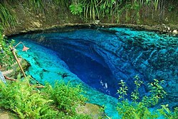
Clear blue waters of the underground river in Barangay Talisay, Hinatuan, popularly called as the "Hinatuan Enchanted River" is a known attraction among tourists both locally and internationally.

Related Research Articles

<span class="mw-page-title-main">Surigao del Sur</span> Province in Caraga, Philippines

Surigao del Sur, officially the Province of Surigao del Sur, is a province in the Philippines located in the Caraga region in Mindanao. Its capital is Tandag City. Surigao del Sur is situated at the eastern coast of Mindanao and faces the Philippine Sea to the east.

<span class="mw-page-title-main">Tandag</span> Capital of Surigao del Sur, Philippines

Tandag, officially the City of Tandag, is a 5th class component city and capital of the province of Surigao del Sur, Philippines. According to the 2020 census, it has a population of 62,669 people.

<span class="mw-page-title-main">Bislig</span> Component city in Surigao del Sur, Philippines

Bislig, officially the City of Bislig, is a 3rd class component city in the province of Surigao del Sur, Philippines. According to the 2020 census, it has a population of 99,290 people.

<span class="mw-page-title-main">Lanuza, Surigao del Sur</span> Municipality in Surigao del Sur, Philippines

Lanuza, officially the Municipality of Lanuza, is a 4th class municipality in the province of Surigao del Sur, Philippines. According to the 2020 census, it has a population of 13,642 people.

<span class="mw-page-title-main">Bacuag</span> Municipality in Surigao del Norte, Philippines

Bacuag, officially the Municipality of Bacuag, is a 5th class municipality in the province of Surigao del Norte, Philippines. According to the 2020 census, it has a population of 14,881 people.

<span class="mw-page-title-main">Loreto, Dinagat Islands</span> Municipality in Dinagat Islands, Philippines

Loreto, officially the Municipality of Loreto, is a 4th class municipality in the province of Dinagat Islands, Philippines. According to the 2020 census, it has a population of 9,690 people.

<span class="mw-page-title-main">Placer, Surigao del Norte</span> Municipality in Surigao del Norte, Philippines

Placer, officially the Municipality of Placer, is a 4th class municipality in the province of Surigao del Norte, Philippines. According to the 2020 census, it has a population of 29,616 people.

<span class="mw-page-title-main">Socorro, Surigao del Norte</span> Municipality in Surigao del Norte, Philippines

Socorro, officially the Municipality of Socorro, is a 4th class municipality in the province of Surigao del Norte, Philippines. According to the 2020 census, it has a population of 25,942 people.

<span class="mw-page-title-main">Tagana-an</span> Municipality in Surigao del Norte, Philippines

Tagana-an, officially the Municipality of Tagana-an, is a 5th class municipality in the province of Surigao del Norte, Philippines. According to the 2020 census, it has a population of 17,323 people.

<span class="mw-page-title-main">Barobo</span> Municipality in Surigao Del Sur, Philippines

Barobo, officially the Municipality of Barobo is a 3rd class municipality in the province of Surigao del Sur, Philippines. According to the 2020 census, it has a population of 53,146 people.

<span class="mw-page-title-main">Bayabas, Surigao del Sur</span> Municipality in Surigao del Sur, Philippines

Bayabas, officially the Municipality of Bayabas, is a 5th class municipality in the province of Surigao del Sur, Philippines. According to the 2020 census, it has a population of 8,979 people.

<span class="mw-page-title-main">Cagwait</span> Municipality in Surigao del Sur, Philippines

Cagwait, officially the Municipality of Cagwait, is a 4th class municipality in the province of Surigao del Sur, Philippines. According to the 2020 census, it has a population of 21,747 people.

<span class="mw-page-title-main">Carmen, Surigao del Sur</span> Municipality in Surigao del Sur, Philippines

Carmen, officially the Municipality of Carmen, is a 5th class municipality in the province of Surigao del Sur, Philippines. According to the 2020 census, it has a population of 11,720 people.

<span class="mw-page-title-main">Carrascal</span> Municipality in Surigao del Sur, Philippines

Carrascal, officially the Municipality of Carrascal, is a 4th class municipality in the province of Surigao del Sur, Philippines. According to the 2020 census, it has a population of 24,586 people.

<span class="mw-page-title-main">Cortes, Surigao del Sur</span> Municipality in Surigao del Sur, Philippines

Cortes, officially the Municipality of Cortes, is a 4th class municipality in the province of Surigao del Sur, Philippines. According to the 2020 census, it has a population of 17,924 people.

<span class="mw-page-title-main">Lianga</span> Municipality in Surigao del Sur, Philippines

Lianga, officially the Municipality of Lianga, is a 4th class municipality in the province of Surigao del Sur, Philippines. According to the 2020 census, it has a population of 33,869 people.

<span class="mw-page-title-main">Lingig</span> Municipality in Surigao del Sur, Philippines

Lingig, officially the Municipality of Lingig, is a 2nd class municipality in the province of Surigao del Sur, Philippines. According to the 2020 census, it had a population of 35,142 people.

<span class="mw-page-title-main">Marihatag</span> Municipality in Surigao del Sur, Philippines

Marihatag, officially the Municipality of Marihatag ;, is a 3rd class municipality in the province of Surigao del Sur, Philippines. According to the 2020 census, it has a population of 19,441 people.

<span class="mw-page-title-main">San Agustin, Surigao del Sur</span> Municipality in Surigao del Sur, Philippines

San Agustin, officially the Municipality of San Agustin, is a 4th class municipality in the province of Surigao del Sur, Philippines. According to the 2020 census, it has a population of 22,855 people.

<span class="mw-page-title-main">Tagbina</span> Municipality in Surigao del Sur, Philippines

Tagbina, officially the Municipality of Tagbina, is a 2nd class municipality in the province of Surigao del Sur, Philippines. According to the 2020 census, it has a population of 41,051 people.

References

  1. Municipality of Hinatuan | (DILG)
  2. "2015 Census of Population, Report No. 3 – Population, Land Area, and Population Density" (PDF). Philippine Statistics Authority. Quezon City, Philippines. August 2016. ISSN   0117-1453. Archived (PDF) from the original on May 25, 2021. Retrieved July 16, 2021.
  3. 1 2 Census of Population (2020). "Caraga". Total Population by Province, City, Municipality and Barangay. Philippine Statistics Authority . Retrieved July 8, 2021.
  4. "PSA Releases the 2018 Municipal and City Level Poverty Estimates". Philippine Statistics Authority. December 15, 2021. Retrieved January 22, 2022.
  5. National Earthquake Information Center (December 2, 2023). "M 7.6 - Mindanao, Philippines". United States Geological Survey. Archived from the original on December 2, 2023. Retrieved December 2, 2023.
  6. "DSWD DROMIC Report #2 on the Mw 7.4 Earthquake Incident in Hinatuan, Surigao del Sur as of 04 December 2023, 6PM". ReliefWeb. December 5, 2023. Retrieved December 6, 2023.
  7. "11,000 families in Hinatuan affected by strong Surigao quake: mayor". ABS-CBN. December 4, 2023. Retrieved December 5, 2023.
  8. "Hinatuan, Surigao del Sur Climatological Normal Values" (PDF). Philippine Atmospheric, Geophysical and Astronomical Services Administration (PDF). Retrieved October 14, 2018.{{cite web}}: Check |archive-url= value (help)
  9. "Hinatuan, Surigao del Sur Climatological Extremes". Philippine Atmospheric, Geophysical and Astronomical Services Administration. Archived from the original on October 14, 2018. Retrieved October 14, 2018.
  10. Census of Population (2015). "Caraga". Total Population by Province, City, Municipality and Barangay. Philippine Statistics Authority . Retrieved June 20, 2016.
  11. Census of Population and Housing (2010). "Caraga" (PDF). Total Population by Province, City, Municipality and Barangay. National Statistics Office . Retrieved June 29, 2016.
  12. Censuses of Population (1903–2007). "Caraga". Table 1. Population Enumerated in Various Censuses by Province/Highly Urbanized City: 1903 to 2007. National Statistics Office.{{cite encyclopedia}}: CS1 maint: numeric names: authors list (link)
  13. "Province of Surigao del Sur". Municipality Population Data. Local Water Utilities Administration Research Division. Retrieved December 17, 2016.
  14. "Poverty incidence (PI):". Philippine Statistics Authority. Retrieved December 28, 2020.
  15. "Estimation of Local Poverty in the Philippines" (PDF). Philippine Statistics Authority. November 29, 2005.
  16. "2003 City and Municipal Level Poverty Estimates" (PDF). Philippine Statistics Authority. March 23, 2009.
  17. "City and Municipal Level Poverty Estimates; 2006 and 2009" (PDF). Philippine Statistics Authority. August 3, 2012.
  18. "2012 Municipal and City Level Poverty Estimates" (PDF). Philippine Statistics Authority. May 31, 2016.
  19. "Municipal and City Level Small Area Poverty Estimates; 2009, 2012 and 2015". Philippine Statistics Authority. July 10, 2019.
  20. "PSA Releases the 2018 Municipal and City Level Poverty Estimates". Philippine Statistics Authority. December 15, 2021. Retrieved January 22, 2022.