Barobo | |
---|---|
Municipality of Barobo | |
![]() Barobo plaque with official seal | |
Nickname: The Gateway of Surigao Del Sur | |
![]() Map of Surigao del Sur with Barobo highlighted | |
Location within the Philippines | |
Coordinates: 8°31′45″N126°07′18″E / 8.5292°N 126.1217°E | |
Country | Philippines |
Region | Caraga |
Province | Surigao del Sur |
District | 2nd district |
Founded | October 24, 1960 |
Barangays | 21 (see Barangays) |
Government | |
• Type | Sangguniang Bayan |
• Mayor | Joey S. Pama |
• Vice Mayor | Allan C. Bernal |
• Representative | Johnny T. Pimentel |
• Electorate | 35,627 voters (2022) |
Area | |
• Total | 242.50 km2 (93.63 sq mi) |
Elevation | 48 m (157 ft) |
Highest elevation | 279 m (915 ft) |
Lowest elevation | 0 m (0 ft) |
Population (2020 census) [3] | |
• Total | 53,146 |
• Density | 220/km2 (570/sq mi) |
• Households | 12,015 |
Demonym | Barobohanon |
Economy | |
• Income class | 3rd municipal income class |
• Poverty incidence | 31.71 |
• Revenue | ₱ 198.4 million (2020), 79.9 million (2012), 89.47 million (2013), 103.4 million (2014), 116.1 million (2015), 127.3 million (2016), 159.2 million (2017), 208.3 million (2018), 179.9 million (2019), 268.4 million (2021), 297.6 million (2022) |
• Assets | ₱ 324.3 million (2020), 99.34 million (2012), 118.9 million (2013), 161.8 million (2014), 143.6 million (2015), 168.7 million (2016), 195.1 million (2017), 205.3 million (2018), 262.9 million (2019), 402.4 million (2021), 488 million (2022) |
• Expenditure | ₱ 173.6 million (2020), 75.22 million (2012), 77.44 million (2013), 91.49 million (2014), 100.9 million (2015), 107.4 million (2016), 136.5 million (2017), 183.7 million (2018), 142.1 million (2019), 181.1 million (2021), 212.3 million (2022) |
• Liabilities | ₱ 64.15 million (2020), 27.36 million (2012), 34.54 million (2013), 69.51 million (2014), 57.99 million (2015), 59.42 million (2016), 74.68 million (2017), 60.7 million (2018), 42.78 million (2019), 55.83 million (2021), 75.54 million (2022) |
Service provider | |
• Electricity | Surigao del Sur 1 Electric Cooperative (SURSECO 1) |
Time zone | UTC+8 (PST) |
ZIP code | 8309 |
PSGC | |
IDD : area code | +63 (0)86 |
Native languages | Surigaonon Agusan Cebuano Kamayo Tagalog |
Website | www |
Barobo, officially the Municipality of Barobo (Surigaonon: Lungsod nan Barobo; Tagalog : Bayan ng Barobo) is a municipality in the province of Surigao del Sur, Philippines. According to the 2020 census, it has a population of 53,146 people. [3]
Legend has it that the Manobo tribesmen first inhabited the area in the central part of Surigao del Sur. Sometime in the 1930s, five families who were engaged in fishing landed in the up-end of the river, and settled in the area for easy access to the fishing grounds. The area became known for its bountiful fish catch, and therefore more people from neighboring areas also came and settled. The distinctive visual quality of the area was an endemic species of tree known as "barobo" (diplodiscus paniculatus), which was plentiful on the site of the settlement. Subsequently, the place became popularly known as Barobo.
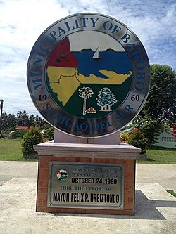
Barobo subsequently became a barrio under the municipality of Lianga. The creation of the province of Surigao del Sur under R.A. No. 2786, series of June 1960, created the municipality of Barobo on October 24, 1960, by virtue of Executive Order No. 407 issued by President Carlos P. Garcia. Thus the Municipality of Barobo was carved out (in a shape resembling that of a cigar pipe) from its mother municipality, Lianga.
Barobo lies in the central part of the province of Surigao del Sur. It is located between 8'34'00" and 8'25'00" latitude and 125'59"00 and 126'22'4" longitude. It is bounded on the north by Lianga Bay and the municipality of Lianga, on the south by the municipality of Tagbina, on the southeast by the municipality of Hinatuan, on the east by the Pacific Ocean, and on the west by the municipality of San Francisco, Agusan del Sur.
It has total land area of 24,250 hectares (59,900 acres). It is linked by a national road to the provincial capital of Tandag, Surigao del Sur, of 103 kilometers (64 mi) and the gateway to the regional center of the Caraga Region in Butuan of 107 kilometers (66 mi).
15,000 hectares (37,000 acres) of its total land is used for the tourism industry with declared tourist destinations namely, Turtle Island, Cabgan Island, Vanishing Islet, Pongpong Resort, Pagbutuanan Cave, Bogac Cold Spring, Beto Lagoon, Panaraga Beach Resorts and Dapdap Beach Resorts. The Barobo River was named as the cleanest urban river in the country by numerous blogging award-giving bodies.
Barobo is politically subdivided into 22 barangays. Each barangay consists of puroks while some have sitios.
Climate data for Barobo | |||||||||||||
---|---|---|---|---|---|---|---|---|---|---|---|---|---|
Month | Jan | Feb | Mar | Apr | May | Jun | Jul | Aug | Sep | Oct | Nov | Dec | Year |
Mean daily maximum °C (°F) | 29.0 (84.2) | 29.1 (84.4) | 30.1 (86.2) | 31.1 (88.0) | 31.7 (89.1) | 31.6 (88.9) | 31.7 (89.1) | 31.9 (89.4) | 31.9 (89.4) | 31.5 (88.7) | 30.7 (87.3) | 29.7 (85.5) | 30.8 (87.5) |
Daily mean °C (°F) | 25.3 (77.5) | 25.4 (77.7) | 26.1 (79.0) | 26.8 (80.2) | 27.4 (81.3) | 27.2 (81.0) | 27.2 (81.0) | 27.3 (81.1) | 27.3 (81.1) | 27.1 (80.8) | 26.5 (79.7) | 25.9 (78.6) | 26.6 (79.9) |
Mean daily minimum °C (°F) | 21.7 (71.1) | 21.8 (71.2) | 22.1 (71.8) | 22.6 (72.7) | 23.2 (73.8) | 22.9 (73.2) | 22.7 (72.9) | 22.8 (73.0) | 22.7 (72.9) | 22.7 (72.9) | 22.4 (72.3) | 22.2 (72.0) | 22.5 (72.5) |
Average rainfall mm (inches) | 639 (25.2) | 482 (19.0) | 402 (15.8) | 297 (11.7) | 264 (10.4) | 227 (8.9) | 207 (8.1) | 198 (7.8) | 211 (8.3) | 221 (8.7) | 325 (12.8) | 535 (21.1) | 4,008 (157.8) |
Source: Climate-Data.org [5] |
Barobo has a tropical rainforest climate (Af) with heavy to very heavy rainfall year-round.
Year | Pop. | ±% p.a. |
---|---|---|
1970 | 16,717 | — |
1975 | 21,090 | +4.77% |
1980 | 23,346 | +2.05% |
1990 | 32,991 | +3.52% |
1995 | 32,226 | −0.44% |
2000 | 34,558 | +1.51% |
2007 | 40,933 | +2.36% |
2010 | 43,663 | +2.38% |
2015 | 49,730 | +2.51% |
2020 | 53,146 | +1.31% |
Source: Philippine Statistics Authority [6] [7] [8] [9] |
A native Barobohanon speaks Kamayo, a minor language spoken in the area of Barobo and also in Bislig, San Agustin and Marihatag, Surigao del Sur province in the southern Philippines. It has 7,565 speakers (2000, WCD). The dialect known as "Kamayo" varies from one municipality to another — Lingiganons are quite different from other municipalities on the way they speak the Kamayo language.
Poverty incidence of Barobo
10 20 30 40 50 2006 42.50 2009 45.65 2012 30.48 2015 43.76 2018 33.17 2021 31.71 Source: Philippine Statistics Authority [10] [11] [12] [13] [14] [15] [16] [17] |
Lanuza, officially the Municipality of Lanuza, is a municipality in the province of Surigao del Sur, Philippines. According to the 2020 census, it has a population of 13,642 people.
Cagdianao, officially the Municipality of Cagdianao, is a municipality in the province of Dinagat Islands, Philippines. According to the 2020 census, it has a population of 18,350 people.
Del Carmen, officially the Municipality of Del Carmen, is a municipality in the province of Surigao del Norte, Philippines. According to the 2015 census, it has a population of 18,392 people. The municipality was formerly called Numancia until 1966 when it was changed to its present name, after its patroness, the Virgin of Carmel. It is located on Siargao Island and home to Sayak Airport, the island's main airport.
General Luna, officially the Municipality of General Luna, is a municipality in the province of Surigao del Norte, Philippines. According to the 2020 census, it has a population of 22,853 people.
Gigaquit, officially the Municipality of Gigaquit, is a municipality in the province of Surigao del Norte, Philippines. According to the 2020 census, it has a population of 21,856 people.
Malimono, officially the Municipality of Malimono, is a municipality in the province of Surigao del Norte, Philippines. According to the 2020 census, it has a population of 18,852 people.
San Benito, officially the Municipality of San Benito, is a municipality in the province of Surigao del Norte, Philippines. According to the 2020 census, it has a population of 5,663 people.
Socorro, officially the Municipality of Socorro, is a municipality in the province of Surigao del Norte, Philippines. According to the 2020 census, it has a population of 25,942 people.
Tubajon, officially the Municipality of Tubajon, is a municipality in the province of Dinagat Islands, Philippines. According to the 2020 census, it has a population of 8,119 people, making it the least populated municipality in the province.
Baganga, officially the Municipality of Baganga, is a municipality in the province of Davao Oriental, Philippines. According to the 2020 census, it has a population of 58,714 people, making it the third largest town in province.
Bayabas, officially the Municipality of Bayabas, is a municipality in the province of Surigao del Sur, Philippines. According to the 2020 census, it has a population of 8,979 people, making it the least populated municipality in the province.
Cagwait, officially the Municipality of Cagwait, is a municipality in the province of Surigao del Sur, Philippines. According to the 2020 census, it has a population of 21,747 people.
Carmen, officially the Municipality of Carmen, is a municipality in the province of Surigao del Sur, Philippines. According to the 2020 census, it has a population of 11,720 people.
Carrascal, officially the Municipality of Carrascal, is a municipality in the province of Surigao del Sur, Philippines. According to the 2020 census, it has a population of 24,586 people.
Lianga, officially the Municipality of Lianga, is a municipality in the province of Surigao del Sur, Philippines. According to the 2020 census, it has a population of 33,869 people.
Lingig, officially the Municipality of Lingig, is a municipality in the province of Surigao del Sur, Philippines. According to the 2020 census, it had a population of 35,142 people.
Marihatag, officially the Municipality of Marihatag ;, is a municipality in the province of Surigao del Sur, Philippines. According to the 2020 census, it has a population of 19,441 people.
San Agustin, officially the Municipality of San Agustin, is a municipality in the province of Surigao del Sur, Philippines. According to the 2020 census, it has a population of 22,855 people.
San Miguel, officially the Municipality of San Miguel, is a municipality in the province of Surigao del Sur, Philippines. According to the 2020 census, it has a population of 41,809 people.
Tagbina, officially the Municipality of Tagbina, is a municipality in the province of Surigao del Sur, Philippines. According to the 2020 census, it has a population of 41,051 people.