Cagwait was spelled "Cacuait" or "Caguait" during the Spanish and American colonial period.[6][7]
Geography
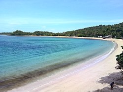
Seashore at a beach located in Cagwait
Cagwait is politically subdivided into 11 barangays.
Cagwait is about 32 kilometres (20mi) southeast of Tandag, the capital town of Surigao del Sur. It is bounded by the towns of Bayabas on the north, Marihatag on the south, the Diwata mountains on the west and the Pacific Ocean in the east. It has a total land area of 21,410 hectares (52,900 acres).
Barangays
Cagwait is politically subdivided into 11 barangays. Each barangay consists of puroks while some have sitios.
Cagwait has an all-weather port at Barangay Bitaugan West (named Aras-asan Port by the Philippine Ports Authority) secured by the natural protection of Arangasa Islands. It has also an abandoned aerodrome made and used by the private planes of Aras-asan Timber Company, Inc. (ARTIMCO) during its peak of timber operation in the late 1970s.
Barangay Poblacion is the seat of governance, while the center of trade of the municipality is in Barangay Aras-asan. It houses three rural banks, two pawnshops, three bakeshops, a radio station, a public terminal and public market. Telecommunication is on par with other neighboring municipalities using cell phones, and Internet via GPRS, and cable television are available. There are also good tourist inns, beach resorts and homestay (bread and breakfast). Motorized tricycles, jeepneys, and buses ply its roads and concrete highways.
Cagwait was the home of the now defunct company ARTIMCO, Inc., one of the largest suppliers of timber in the country. Its land holdings became a sanctuary of the Philippine Eagle. Its land holdings became a sanctuary of the Philippine Eagle which was discovered by Charles Lindbergh during his wildlife expedition. He also discovered the beautiful white-sand beach cove of Cagwait which he described as similar to Waikiki Beach in Hawaii.
Cagwait beach is the venue for the popular annual Kaliguan festival. Normally held towards the end of June, the festival is held over three days. A temporary stage is constructed on the beach and features music and a beauty pageant known as Perlas Ng Kaliguan. The most recent festival held in June 2019 was the 23rd annual Kaliguan festival.
↑Coast and Geodetic Survey (1940). United States Coast Pilot: Philippine Islands, Part II: Palawan, Mindanao, and Sulu Archipelago. Washington: United States Government Printing Office. p.351.
↑Santayana, Agustín (1862). La isla de Mindanao su historia y su estado presente, con algunas reflexiones acerca de su porvenir. Imprenta de Alhambra y Comp. p.81.
↑Census of Population (2015). "Caraga". Total Population by Province, City, Municipality and Barangay. Philippine Statistics Authority. Retrieved June 20, 2016.
↑Census of Population and Housing (2010). "Caraga"(PDF). Total Population by Province, City, Municipality and Barangay. National Statistics Office. Retrieved June 29, 2016.
This page is based on this Wikipedia article Text is available under the CC BY-SA 4.0 license; additional terms may apply. Images, videos and audio are available under their respective licenses.