Cantilan

Last updated

Cantilan
Municipality of Cantilan
Cantilan Harbour.JPG
Cantilan Harbour
Flag of Cantilan, Surigao del Sur.png
Ph locator surigao del sur cantilan.png
Map of Surigao del Sur with Cantilan highlighted
OpenStreetMap
Cantilan
Philippines location map (square).svg
Red pog.svg
Cantilan
Location within the Philippines
Coordinates: 9°20′08″N125°58′37″E / 9.3356°N 125.9769°E / 9.3356; 125.9769
Country Philippines
Region Caraga
Province Surigao del Sur
District 1st district
Founded 1782
Barangays 17 (see Barangays)
Government
[1]
  Type Sangguniang Bayan
   Representative Romeo S. Momo Sr.
   Electorate 24,422 voters (2022)
Area
[2]
  Total240.10 km2 (92.70 sq mi)
Elevation
9.0 m (29.5 ft)
Highest elevation
196 m (643 ft)
Lowest elevation
0 m (0 ft)
Population
 (2020 census) [3]
  Total34,060
  Density140/km2 (370/sq mi)
   Households
8,115
Economy
   Income class 2nd municipal income class
   Poverty incidence
19.17
% (2018) [4]
   Revenue 199.3 million (2020)
   Assets 721.5 million (2020)
   Expenditure 172.6 million (2020)
   Liabilities 131.5 million (2020)
Service provider
  ElectricitySurigao del Sur 2 Electric Cooperative (SURSECO 2)
Time zone UTC+8 (PST)
ZIP code
8317
PSGC
IDD : area code +63(0)86
Native languages Surigaonon
Agusan
Cebuano
Tagalog
Website www.cantilan.gov.ph

Cantilan, officially the Municipality of Cantilan (Surigaonon: Lungsod nan Cantilan; Tagalog : Bayan ng Cantilan), is a 2nd class municipality in the province of Surigao del Sur, Philippines. According to the 2020 census, it has a population of 34,060 people. [3]

Contents

Cantilan is considered the "Cradle of Towns" in Surigao del Sur. It originally encompassed the whole area of Carcanmadcarlan or the present towns of Carrascal, Cantilan, Madrid, Carmen and Lanuza.

History

Cantilan existed as a settlement for more than three centuries as early as 1622.

According to legend, the word Cantilan originated from the big shell of a bivalve locally called, "Tilang". A couple with beautiful daughters lived close to the location of the big shell. When suitors came to visit the daughters and were asked their destination, they would answer, “Can Tilang” (meaning “to Tilang’s"). Eventually, "Can Tilang" became "Cantilan". [5]

According to sources, it was created by virtue of the Spanish Royal Decree of 1768 known as Maura Law. Another source states however, that Fr. Valerio de San Agustin implemented it in 1782 at "Daan Lungsod," the old town in the coastal area. It was populated with people from Bayuyo, Ilihan and Calagdan. They constructed a fortification, a "Kuta", (Fort) made of limestone later named as Baluarte de Señor San Miguel, located across the river in the modern Cantilan.

Caraga is obviously named after the old, historic Caraga, an extensive landmass covering several provinces, in the northeastern seaboard of Mindanao whose existence outdated the arrival of the Spaniards in this country.

The people of the old Calagan were originally from Ilihan (now Panikian), Calagan (now Calagda-an), Parasao (now Palasao) and Bayuyo (now Union, Manga and San Antonio).

1521 – For the first time, Antonio Pigafetta, the chronicler of Magellan's epic voyage around the world, called this region Calagam or Calagan.

Calagan was among the three choices for Ferdinand Magellan to dock for provisions and trade. "Magellan was anxious to resume his voyage and inquired which were the best ports for provisions and trade, wishing to turn of his many articles of barter into gold and spices. He was told that there were three – Ceylon (Leyte), Zzubu (Cebu) and Calagan, but that Zzubu was the largest and had the most traffic."

March 31, 1521 – The celebrated "Primera Misa", an Easter Sunday Mass, was held in the Philippine Territory on the order of Ferdinand Magellan. Two of its prominent attendees were the Butuan brother kings: Rajah Kolambu of Butuan and Rajah Siagu of Calagan.

January 25, 1571 – Garcia Sierras Chacon was appointed to rule the district of Surigao and Parasao (Cantilan), an encomienda.

the Northeastern portion of Mindanao to be raised to the status of a province. This "distrito" was called "Provincia de Caraga" with Tandag as the capital.

Cantilan has existed as a settlement for more than three centuries on the two barrios of Bayoyo and Kalagda-an which was then included in the Spanish administration of Tandag as early as 1709. The settlement of Ilihan was also part of the Cantilan area that time.

Prior to the Spanish regime, inhabitants of Cantilan were Bagani Bankayan Sandigan people, who descended from Malay immigrants. At times the early settlers were forced to join and fight marauding bands who came for slaves and plundered. In the process, they built stone walls and a watchtower as can be shown on some ruins of these structures which still exist on the sea coast.

The Spanish arrived and established a settlement at "Daan Lungsod" (Old Town) in the early 1700s and (Cantilan was separated from Tandag in 1791). The Spanish introduced Christianity and a governmental administration headed by a priest.

Compulsory taxation was later featured from Spanish rule. Other legacies of the Spanish time were the Spanish name given to the local inhabitants and the Spanish words which were added to the local language. The Jesuit fathers constructed a church in Cantilan in the 1890s – part of the walls still stands near the new church constructed in 1959.

During the Spanish time, local people were frequently attacked by Muslims and so a fort was built at Daan Lungsod which aided in repelling five attacks, ending once and for all these raids. Other problems were diseases (especially smallpox and other epidemics) were on the rise added with disasters like a typhoon.

In 1856, Daan Lungsod was destroyed by a disastrous typhoon on the night of October 14. Beginning at midnight and continuing through the entire next day. A typhoon and series of storm surges rolled over the town sweeping away all but one house and killing 30 people as well as destroying crops and livestock. The ruins of Daan Lungsod can still be seen on the other side of Cantilan River, but after the storm, it was decided to rebuild the town on its present site.

Before the storm, residents often crossed the river to buy fish from a woman named Tilang. When asked where they were going, they replied, "Adto Kan Tilang"; and the place gradually became known as Kantilang (Cantilan to Spanish). After the storm, the new town was built in this area, across the river and was named Kantilang or Cantilan.

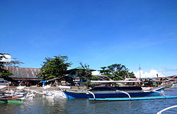
Throughout the period, Cantilan remained primarily a fishing and agricultural settlement, as it is today. The area was larger at that time because it comprised the present municipalities of Cantilan, Carrascal, Madrid, Carmen and Lanuza (CarCanMadCarLan)

The first Americans set foot in Surigao in 1904 and were met some active resistance. But fighting died out after a relatively short time. The main American contribution to Filipino life was the restructuring of governmental administration and the public schools. (Some early teachers were Mr. Bonnie, Mr. & Mrs. Edward Taylor, and Mr. William Hotchkiss).

During World War II, Cantilangnons were very active as guerillas fighting against the Japanese, who established a garrison in Cantilan from June 1942 to 1944.

The Japanese were headquartered in the present day Municipal Hall and formations were often held at the plaza. The people were afraid and forced to flee to the mountains or to the outlying island to avoid the Japanese. In some barrios, like Barangay General Island, the population increased on account of the mass evacuation. Peacetime at last came when the Japanese finally withdraw their troops from Cantilan because of the invasion of the Americans in Leyte.

Years rolled along after full Independence was granted to the Philippines in 1946. Cantilan became part of the new province of Surigao del Sur in 1960. It had also taken and fixed its present boundaries at that time, with the creation of Madrid as a new municipality.

Cantilan remains primarily a rural, agricultural and fishing municipality, but its residents are well known for their high standing standard of education obtained by a large number of professionals who hail from Cantilan.

In more recent times, the logging and timber industry has had an impact in Cantilan, both logging and veneer manufacturing plant operating in this town. It has also a potential for mining, although no large-scale operations have as yet been undertaken.

Geography

Cantilan is the second northernmost municipality of CarCanMadCarLan and so also the second northernmost municipality of the province. The neighbouring municipalities are Carrascal in the north-west and Madrid in the south-east.

Barangays

Cantilan is politically subdivided into 17 barangays. Each barangay consists of puroks while some have sitios.

Buntalid and Magasang were constituted as barrios in 1956. [7]

  • Bugsukan
  • Buntalid
  • Cabangahan
  • Cabas-an
  • Calagdaan
  • Consuelo
  • General Island
  • Lininti-an (Poblacion)
  • Lobo
  • Magasang
  • Magosilom (Poblacion)
  • Pag-Antayan
  • Palasao
  • Parang
  • San Pedro
  • Tapi
  • Tigabong

Climate

Climate data for Cantilan
MonthJanFebMarAprMayJunJulAugSepOctNovDecYear
Average high °C (°F)28.7
(83.7)
29.0
(84.2)
29.9
(85.8)
31.0
(87.8)
31.8
(89.2)
31.8
(89.2)
31.7
(89.1)
31.9
(89.4)
31.8
(89.2)
31.2
(88.2)
30.2
(86.4)
29.2
(84.6)
30.7
(87.2)
Daily mean °C (°F)25.5
(77.9)
25.6
(78.1)
26.3
(79.3)
27.0
(80.6)
27.8
(82.0)
27.7
(81.9)
27.7
(81.9)
27.8
(82.0)
27.6
(81.7)
27.2
(81.0)
26.6
(79.9)
25.9
(78.6)
26.9
(80.4)
Average low °C (°F)22.4
(72.3)
22.3
(72.1)
22.7
(72.9)
23.1
(73.6)
23.9
(75.0)
23.7
(74.7)
23.7
(74.7)
23.7
(74.7)
23.5
(74.3)
23.3
(73.9)
23.1
(73.6)
22.7
(72.9)
23.2
(73.7)
Average rainfall mm (inches)906
(35.7)
753
(29.6)
593
(23.3)
412
(16.2)
243
(9.6)
167
(6.6)
145
(5.7)
128
(5.0)
145
(5.7)
227
(8.9)
513
(20.2)
757
(29.8)
4,989
(196.3)
Source: Climate-Data.org [8]

Cantilan has a tropical rainforest climate (Af) with heavy to very heavy rainfall year-round and with extremely heavy rainfall from December to February.

Demographics

Population census of Cantilan
YearPop.±% p.a.
1903 7,481    
1918 18,594+6.26%
1939 18,408−0.05%
1948 20,519+1.21%
1960 11,793−4.51%
1970 16,617+3.48%
1975 18,192+1.83%
1980 20,889+2.80%
1990 24,868+1.76%
1995 24,061−0.62%
2000 26,553+2.14%
2007 28,659+1.06%
2010 30,231+1.96%
2015 31,492+0.78%
2020 34,060+1.55%
Source: Philippine Statistics Authority [9] [10] [11] [12]

The inhabitants of Cantilan are called Cantilangnons. Its unique dialect is called Cantelangnon, a variant of the Surigaonon language.

Economy

Coast Fishing in Cantilan Cantilan Coast Fishing.JPG
Coast Fishing in Cantilan

The main part is agriculture (rice, coconut palms), animal breeding (water buffalos, pigs and chickens/roosters) and coastal fishing.

Tourism

Beach Resort at bay-bay Cantilan Bay Bay.JPG
Beach Resort at bay-bay

Points of interest:

Sirong Festival

The Sirong Festival is a mardi-gras parade participated by different contingents from other towns. A cash price and a trophy awaits to the winner of the street dancing competition and the final showdown (2009 Sirong Festival Champion (SURIGAO CITY, SDN Contingent)).

Transportation

Town proper

Pedicabs roam around the streets of Cantilan.

By Land

Buses ("Bachelor Express"), Vans and Jeepneys ply from Cantilan to Tandag and Surigao City v.v. on the coast-road of Surigao-Tandag. Roads are semi-concrete.

By Sea

Inter-island vessels like 2Go ply the Manila-Surigao City routes on regular schedules. Cokaliong also has schedules from Cebu-Surigao City routes on a daily basis. The harbour in the Cantilan river can be used by Pump boats only. On the east side of the Capungan peninsula that separates the Lanuza bay from Carrascal bay exists "Consuelo Port" which is a harbour for bigger ships.

By Air

The closest airports are Surigao Airport (IATA: SUG, ICAO: RPMS) and Butuan Airport (IATA: BXU, ICAO: RPME). The Tandag Airfield (IATA: TDG, ICAO: RPMW) has limited flights from Manila and Cebu City which started on June 30, 2014.

Education

Surigao del Sur State University Cantilan Uni 3.JPG
Surigao del Sur State University

Cantilan has both public and private schools from elementary, secondary and tertiary.

Notable personalities

Related Research Articles

<span class="mw-page-title-main">Agusan del Norte</span> Province in Caraga, Philippines

Agusan del Norte, officially the Province of Agusan del Norte, is a province in the Caraga region of the Philippines. Its capital is the city of Cabadbaran with several government offices located in the city of Butuan. It is bordered on the northwest by Butuan Bay; northeast by Surigao del Norte; mid-east by Surigao del Sur; southeast by Agusan del Sur, and southwest by Misamis Oriental.

<span class="mw-page-title-main">Surigao del Norte</span> Province in Caraga, Philippines

Surigao del Norte, officially the Province of Surigao del Norte, is a province in the Philippines located in the Caraga region of Mindanao. The province was formerly under the jurisdiction of Region 10 until 1995. Its capital is Surigao City. The province comprises two major islands—Siargao and Bucas Grande—in the Philippine Sea, plus a small area at the northeastern tip of mainland Mindanao and other surrounding minor islands and islets. This mainland portion borders Agusan del Norte – between the Municipality of Alegria in Surigao del Norte and the Municipality of Kitcharao in Agusan del Norte; and the province of Surigao del Sur, to the south.

<span class="mw-page-title-main">Surigao del Sur</span> Province in Caraga, Philippines

Surigao del Sur, officially the Province of Surigao del Sur, is a province in the Philippines located in the Caraga region in Mindanao. Its capital is Tandag City. Surigao del Sur is situated at the eastern coast of Mindanao and faces the Philippine Sea to the east.

<span class="mw-page-title-main">Caraga</span> Administrative region of the Philippines

Caraga, officially the Caraga Administrative Region and designated as Region XIII, is an administrative region in the Philippines occupying the northeastern section of Mindanao. The region was created through Republic Act No. 7901 on February 23, 1995. The region comprises five provinces: Agusan del Norte, Agusan del Sur, Dinagat Islands, Surigao del Norte, and Surigao del Sur; six cities: Bayugan, Bislig, Butuan, Cabadbaran, Surigao and Tandag; 67 municipalities and 1,311 barangays. Butuan, the most urbanized city in Caraga, serves as the regional administrative center.

<span class="mw-page-title-main">Tandag</span> Capital of Surigao del Sur, Philippines

Tandag, officially the City of Tandag, is a 5th class component city and capital of the province of Surigao del Sur, Philippines. According to the 2020 census, it has a population of 62,669 people.

<span class="mw-page-title-main">Mainit</span> Municipality in Surigao del Norte, Philippines

Mainit, officially the Municipality of Mainit, is a 4th class municipality in the province of Surigao del Norte, Philippines. According to the 2020 census, it has a population of 28,019 people.

<span class="mw-page-title-main">Sibagat</span> Municipality in Agusan del Sur, Philippines

Sibagat, officially the Municipality of Sibagat, is a 1st class municipality in the province of Agusan del Sur, Philippines. According to the 2020 census, it has a population of 33,957 people.

<span class="mw-page-title-main">Bislig</span> Component city in Surigao del Sur, Philippines

Bislig, officially the City of Bislig, is a 3rd class component city in the province of Surigao del Sur, Philippines. According to the 2020 census, it has a population of 99,290 people.

<span class="mw-page-title-main">Alegria, Surigao del Norte</span> Municipality in Surigao del Norte, Philippines

Alegria, officially the Municipality of Alegria, is a 5th class municipality in the province of Surigao del Norte, Philippines. According to the 2020 census, it has a population of 16,184 people.

<span class="mw-page-title-main">Lanuza, Surigao del Sur</span> Municipality in Surigao del Sur, Philippines

Lanuza, officially the Municipality of Lanuza, is a 4th class municipality in the province of Surigao del Sur, Philippines. According to the 2020 census, it has a population of 13,642 people.

<span class="mw-page-title-main">Bayugan</span> Component city in Agusan del Sur, Philippines

Bayugan, officially the City of Bayugan, is a 5th class component city in the province of Agusan del Sur, Philippines. According to the 2020 census, it has a population of 109,499 people..

<span class="mw-page-title-main">San Francisco, Agusan del Sur</span> Municipality in Agusan del Sur, Philippines

San Francisco, officially the Municipality of San Francisco, is a 1st class municipality in the province of Agusan del Sur, Philippines. According to the 2020 census, it has a population of 80,760 people.

<span class="mw-page-title-main">Placer, Surigao del Norte</span> Municipality in Surigao del Norte, Philippines

Placer, officially the Municipality of Placer, is a 4th class municipality in the province of Surigao del Norte, Philippines. According to the 2020 census, it has a population of 29,616 people.

<span class="mw-page-title-main">Surigao City</span> Capital of Surigao, Philippines

Surigao City, officially the City of Surigao, is a 1st class component city and capital of the province of Surigao del Norte, Philippines. According to the 2020 census, it has a population of 171,107 people.

<span class="mw-page-title-main">Barobo</span> Municipality in Surigao del Sur, Philippines

Barobo, officially the Municipality of Barobo, is a 3rd class municipality in the province of Surigao del Sur, Philippines. According to the 2020 census, it has a population of 53,146 people.

<span class="mw-page-title-main">Carrascal</span> Municipality in Surigao del Sur, Philippines

Carrascal, officially the Municipality of Carrascal, is a 4th class municipality in the province of Surigao del Sur, Philippines. According to the 2020 census, it has a population of 24,586 people.

<span class="mw-page-title-main">Cortes, Surigao del Sur</span> Municipality in Surigao del Sur, Philippines

Cortes, officially the Municipality of Cortes, is a 4th class municipality in the province of Surigao del Sur, Philippines. According to the 2020 census, it has a population of 17,924 people.

<span class="mw-page-title-main">Lianga</span> Municipality in Surigao del Sur, Philippines

Lianga, officially the Municipality of Lianga, is a 4th class municipality in the province of Surigao del Sur, Philippines. According to the 2020 census, it has a population of 33,869 people.

<span class="mw-page-title-main">Madrid, Surigao del Sur</span> Municipality in Surigao del Sur, Philippines

Madrid, officially the Municipality of Madrid, is a 4th class municipality in the province of Surigao del Sur, Philippines. According to the 2020 census, it has a population of 16,653 people.

<span class="mw-page-title-main">Tago, Surigao del Sur</span> Municipality in Surigao del Sur, Philippines

Tago, officially the Municipality of Tago, is a 2nd class municipality in the province of Surigao del Sur, Philippines. According to the 2020 census, it has a population of 39,831 people.

References

  1. Municipality of Cantilan | (DILG)
  2. "2015 Census of Population, Report No. 3 – Population, Land Area, and Population Density" (PDF). Philippine Statistics Authority. Quezon City, Philippines. August 2016. ISSN   0117-1453. Archived (PDF) from the original on May 25, 2021. Retrieved July 16, 2021.
  3. 1 2 Census of Population (2020). "Caraga". Total Population by Province, City, Municipality and Barangay. Philippine Statistics Authority . Retrieved July 8, 2021.
  4. "PSA Releases the 2018 Municipal and City Level Poverty Estimates". Philippine Statistics Authority. December 15, 2021. Retrieved January 22, 2022.
  5. Historical timeline of Cantilan.
  6. Virginia Hansen Holmes, Guerrilla Daughter (Kent, Ohio: Kent State U. Press, 2009), pp. 119.
  7. "An Act Converting into Barrios Certain Sitios in the Province of Surigao, and Dividing the Barrio of Macalaya into Two Barrios, Municipality of Placer, in the Same Province". LawPH.com. Retrieved April 12, 2011.
  8. "Climate: Cantilan". Climate-Data.org. Retrieved October 26, 2020.
  9. Census of Population (2015). "Caraga". Total Population by Province, City, Municipality and Barangay. Philippine Statistics Authority . Retrieved June 20, 2016.
  10. Census of Population and Housing (2010). "Caraga". Total Population by Province, City, Municipality and Barangay. National Statistics Office . Retrieved June 29, 2016.
  11. Censuses of Population (1903–2007). "Caraga". Table 1. Population Enumerated in Various Censuses by Province/Highly Urbanized City: 1903 to 2007. National Statistics Office.
  12. "Province of Surigao del Sur". Municipality Population Data. Local Water Utilities Administration Research Division. Retrieved December 17, 2016.
  13. "Poverty incidence (PI):". Philippine Statistics Authority. Retrieved December 28, 2020.
  14. "Estimation of Local Poverty in the Philippines" (PDF). Philippine Statistics Authority. November 29, 2005.
  15. "2003 City and Municipal Level Poverty Estimates" (PDF). Philippine Statistics Authority. March 23, 2009.
  16. "City and Municipal Level Poverty Estimates; 2006 and 2009" (PDF). Philippine Statistics Authority. August 3, 2012.
  17. "2012 Municipal and City Level Poverty Estimates" (PDF). Philippine Statistics Authority. May 31, 2016.
  18. "Municipal and City Level Small Area Poverty Estimates; 2009, 2012 and 2015". Philippine Statistics Authority. July 10, 2019.
  19. "PSA Releases the 2018 Municipal and City Level Poverty Estimates". Philippine Statistics Authority. December 15, 2021. Retrieved January 22, 2022.
  20. "BGen.Hernando Iriberri". Philippine Daily Inquirer. Appointed commander of the Army’s 503rd Brigade in Abra province. Retrieved January 31, 2013.