Agusan del Norte, officially the Province of Agusan del Norte, is a province in the Caraga region of the Philippines. Its capital is the city of Cabadbaran with several government offices located in the city of Butuan. It is bordered on the northwest by Butuan Bay; northeast by Surigao del Norte; mid-east by Surigao del Sur; southeast by Agusan del Sur, and southwest by Misamis Oriental.

Surigao del Norte is a province in the Philippines located in the Caraga region of Mindanao. The province was formerly under the jurisdiction of Region 10 until 1995. Its capital is Surigao City. The province comprises two major islands—Siargao and Bucas Grande—in the Philippine Sea, plus a small area at the northeastern tip of mainland Mindanao and other surrounding minor islands and islets. This mainland portion borders Agusan del Norte – between the Municipality of Alegria in Surigao del Norte and the Municipality of Kitcharao in Agusan del Norte; and the province of Surigao del Sur, to the south.

Surigao del Sur is a province in the Philippines located in the Caraga region in Mindanao. Its capital is Tandag City. Surigao del Sur is situated at the eastern coast of Mindanao and faces the Philippine Sea to the east.

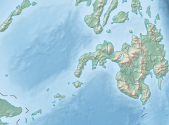
Caraga, officially the Caraga Administrative Region and designated as Region XIII, is an administrative region in the Philippines occupying the northeastern section of Mindanao. The region was created through Republic Act No. 7901 on February 23, 1995. The region comprises five provinces: Agusan del Norte, Agusan del Sur, Dinagat Islands, Surigao del Norte, and Surigao del Sur; six cities: Bayugan, Bislig, Butuan, Cabadbaran, Surigao and Tandag; 67 municipalities and 1,311 barangays. Butuan, the most urbanized city in Caraga, serves as the regional administrative center.

Tandag, officially known as the City of Tandag, is a 5th class component city and capital of the province of Surigao del Sur, Philippines. According to the 2020 census, it has a population of 62,669 people.

Nettlebed Cave is a limestone cave located in the Mount Arthur region of the northwest South Island of New Zealand. The presence of ongaonga, an endemic tree nettle, near the bottom entrance gives the cave its name.
Bislig, officially known as the City of Bislig, is a 3rd class component city in the province of Surigao del Sur, Philippines. According to the 2020 census, it has a population of 99,290 people.

Surigao City, officially known as the City of Surigao, is a 3rd class component city and capital of the province of Surigao del Norte, Philippines. According to the 2020 census, it has a population of 171,107 people.

The Great Blue Hole is a giant marine sinkhole off the coast of Belize. It lies near the center of Lighthouse Reef, a small atoll 70 km (43 mi) from the mainland and Belize City. The hole is circular in shape, 318 m (1,043 ft) across and 124 m (407 ft) deep. It has a surface area of 70,650 square metres (760,500 sq ft). It was formed during several episodes of quaternary glaciation when sea levels were much lower. Analysis of stalactites found in the Great Blue Hole shows that formation took place 153,000, 66,000, 60,000, and 15,000 years ago. As the ocean began to rise again, the cave was flooded. The Great Blue Hole is a part of the larger Belize Barrier Reef Reserve System, a FLOHA World Heritage Site.
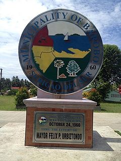
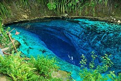
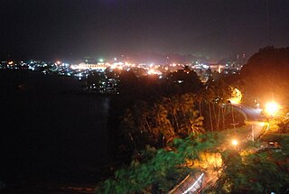
Barobo, officially the Municipality of Barobo, is a 3rd class municipality in the province of Surigao del Sur, Philippines. According to the 2020 census, it has a population of 53,146 people.

Bayabas, officially the Municipality of Bayabas, is a 5th class municipality in the province of Surigao del Sur, Philippines. According to the 2020 census, it has a population of 8,979 people.

Hinatuan is a second class municipality in the province of Surigao del Sur, Philippines. According to the 2020 census, it has a population of 43,841 people.
Lianga, officially the Municipality of Lianga, is a 4th class municipality in the province of Surigao del Sur, Philippines. According to the 2020 census, it has a population of 33,869 people.

The Dinagat Islands are a group of islands constituting a province in the Caraga region in the Philippines, located on the south side of Leyte Gulf. The island of Leyte is to its west, across Surigao Strait, and Mindanao is to its south. Its main island, Dinagat, is about 60 kilometres (37 mi) from north to south. Declared a province in 2006, the Dinagat Islands comprise the second newest province of the Philippines, with Davao Occidental (2013) being the newest.

Wakulla Springs is located 14 miles (23 km) south of Tallahassee, Florida and 5 miles (8.0 km) east of Crawfordville in Wakulla County, Florida at the crossroads of State Road 61 and State Road 267. It is protected in the Edward Ball Wakulla Springs State Park.
The Blue Hole of Santa Rosa, or simply the Blue Hole, is a circular, bell-shaped pool or small lake located along Route 66 east of Santa Rosa, New Mexico that is a tourist attraction and swimming venue, and one of the most popular dive destinations in the US for scuba diving and training. The Blue Hole is an artesian well and cenote that was once used as a fish hatchery.
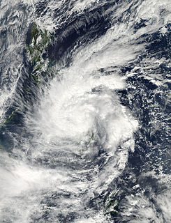
Tropical Storm Jangmi, known in the Philippines as Tropical Storm Seniang, was a weak but destructive tropical cyclone that impacted the Philippines during late December 2014. It produced heavy rainfall which caused serious flooding. Flooding in Philippines caused 66 deaths and at least $28.3 million damage.
Nickel Asia Corporation (NAC) is a Philippine mining company based at the Bonifacio Global City in Taguig, Metro Manila which primarily mines lateritic nickel ore.
Mount Diwata, also locally unofficially nicknamed Diwalwal, is a remote 1,261-metre (4,137 ft) high range of volcanic mountain and biodiversity area in Davao Region on eastern part of Mindanao island of Philippines. Rich in gold and copper ores and mines, it is spread across the 3 municipalities: (a) Monkayo in the province of Davao de Oro; as well as (b) Cateel and (c) Boston in the province of Davao Oriental. Laguna Copperplate Inscription, the oldest written document in Philippines dated to 900 CE, refers to Mount Diwata.

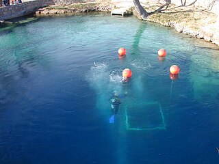
Cave diving is underwater diving in water-filled caves. The equipment used varies depending on the circumstances, and ranges from breath hold to surface supplied, but almost all cave diving is done using scuba equipment, often in specialised configurations with redundancies such as sidemount or backmounted twinset. Recreational cave diving is generally considered to be a type of technical diving due to the lack of a free surface during large parts of the dive, and often involves planned decompression stops. A distinction is made by recreational diver training agencies between cave diving and cavern diving, where cavern diving is deemed to be diving in those parts of a cave where the exit to open water can be seen by natural light. An arbitrary distance limit to the open water surface may also be specified. Despite the risks, water-filled caves attract scuba divers, cavers, and speleologists due to their often unexplored nature, and present divers with a technical diving challenge.