Abra is from the Spanish word abre meaning gorge, pass, breach or opening. It was first used by the Spaniards to denote the region above the Banaoang Gap where the Abra River exits into the South China Sea, thus the Rio Grande de Abra.[3]
History
This section needs expansion. You can help by adding to it. (December 2015)
Early history
The first inhabitants of Abra were the ancestors of the Bontocs and the Ifugaos. These inhabitants eventually left to settle in the old Mountain Province. Other early inhabitants were the Tinguians or Itnegs.
In 1598, Bangued was occupied by Spanish-Iloco forces. The Spanish established a garrison to protect their missionaries from headhunters so that they could Christianize the Tinguians and locate gold mines. This led to the Ilocano settlement of this area.
Bangued was under the care of the Spanish missions in Vigan and Bantay. Fr. Esteban Marin and Fr. Agustin Minon established a mission in Bangued as early as 1598. On April 5, 1612, Fr. Pedro Columbo became the first minister. It would seem that this actuation of the Augustinians was precipitated by the Dominican takeover of the ministry of Narvacan since the Dominicans wanted to convert Narvacan into a mission center to evangelize the other parts of Abra. To check this Dominican move, the Augustinians elevated Bangued to a ministry.
Fr. Juan Pareja OSA, a former parish priest in Bantay, led the conversion of the province. He came to Abra in 1626 and is reported to have converted as many as 3,000 inhabitants, including the chieftain Miguel Dumaoal. He founded the mission of San Diego and later the ministry of Bangued. He established the following towns as visitas of Bangued: Tayum, Sabangan and Bucao (now Dolores). Inspired by Fr. Pareja, these towns battled almost daily against the rancherias of Palang, Talamuy, Bataan, Cabulao, Calaoag, and Langiden.
Fr. Jose Polanco OP also contributed to the conversion of Abra. A man of austere mortification, he died in Abra in 1679 and was considered a saint by the locals.
Fr. Bernardino Lago OSA arrived in the early 19th century. In 1823, Fr. Lago began work in Pidigan. After 25 years, the Christians were numbered about a thousand "baptized, living in community, with schools, church and municipal house, tilling the earth to support themselves and their children." Fr. Lago also founded the town of La Paz. Fr. Galende enumerates the foundation of the other towns of Abra:
Originally, the area was called El Abra de Vigan ("The Opening of Vigan"). During the British Occupation of the Philippines, Gabriela Silang and her army fled to Abra from Ilocos and continued the revolt begun by her slain husband Diego Silang. She was captured and hanged by authorities in 1763.
In 1818, the Ilocos region was divided into Ilocos Norte and Ilocos Sur. On October 9, 1846, Abra became an independent province with the capital and residence of the provincial governor located in Bucay. In 1863, the capital was transferred to Bangued, the province's oldest town. It remained so until the arrival of the Americans in 1899.
American occupation
In 1908, the Philippine Commission annexed Abra into Ilocos Sur in an attempt to resolve Abra's financial difficulties. On March 9, 1917, the Philippine Assembly re-established Abra as a province under Act 2683.[4]
Japanese occupation
During World War II, Japanese forces occupied Abra in 1942. The province was liberated by Filipino soldiers and guerrillas in 1945.[further explanation needed]
This section needs expansion. You can help by adding to it. (March 2016)
The beginning months of the 1970s marked a period of turmoil and change in the Philippines, as well as in Abra.[5] During his bid to be the first Philippine president to be re-elected for a second term, Ferdinand Marcos launched an unprecedented number of public works projects. This caused[6][7] the Philippine economy took a sudden downwards turn known as the 1969 Philippine balance of payments crisis, which in turn led to a period of economic difficulty and social unrest.[8][9]:"43"[10][11]
With only a year left in his last constitutionally allowed term as president, Ferdinand Marcos placed the Philippines under Martial Law in September 1972 and thus retained the position for fourteen more years.[12] This period in Philippine history is remembered for the Marcos administration's record of human rights abuses,[13][14] particularly targeting political opponents, student activists, journalists, religious workers, farmers, and others who fought against the Marcos dictatorship.[15] In Abra, many of the victims were from the indigenous Itneg people (known then among most lowlanders as the Tingguian people, which is an exonym). Numerous human rights abuses against Itnegs were documented in the various Amnesty International missions which allowed to conduct investigations in the country after Marcos had to give in to political pressure.[16]
On May 6, 1983, Sitio Beew in the Municipality of Tubo was the site of several attacks by the 623rd Philippine Constabulary (623rd PC) led by Captain Berido, Lt. Rehaldo Lebua and Lt. Juanito Puyawan, which would collectively come to be known as the "Beew massacre." The 623rd PC burned down four houses and a rice granary, which still contained the remains of three villagers including an unborn baby, and Barangay Councilman Rodolfo Labawig, pregnant mother Josefina Cayandag, and her unborn child.[17] Beew residents, including babies and toddlers, were beaten and their houses looted in response to the residents' alleged support of protests against the logging operations of Herminio Disini's Cellophil Resources Corporation in their area.[17]
Later 20th Century
The revolutionary Marxist priest Conrado Balweg, who fought for the rights of the Cordillera tribes, began his crusade in Abra. After successfully negotiating a peace accord with Balweg's group in 1987, the Philippine government created the Cordillera Administrative Region, which includes Abra.[18]
Contemporary history
On July 27, 2022, a magnitude 7.0 earthquake, jolted the province. Eleven people died (at least seven of them were from Abra), and more than 600 were injured.[19] A magnitude 6.4 aftershock three months later injured more than 100 people and caused additional damage.[20]
The province is notorious for its election-related crimes, hence earning some nicknames including the title as the "Killing Fields of the North." Through the decades, there have been numerous assassinations of alleged supporters, former politicians, and even incumbent officials. These killings include the gunning incident that took the life of then Vice Governor Rafael Blanco[21]; and the more recent and notorious incident involving Rep. Luis Bersamin in 2006, which earned nationwide attention. These election-related crimes typically occur months before and during both the midterm and general elections. Most especially weeks before the official filing of COCs (Certificate of Candidacy), and during the campaign period. With this, the Commission on Elections along with concerned agencies (e.g. DILG, PNP, etc.), usually identifies several municipalities in the province as "areas of concern," in which they bear the Category Red in terms of election hot spots.
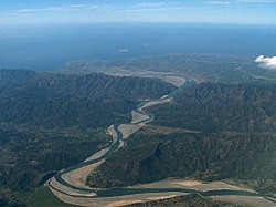
The province is bordered by the towering mountain ranges of the Ilocos in the west and the Cordillera Central in the east. The Abra River runs from the south in Benguet to the west and central areas bisecting the Abra Valley. It is joined by the Tineg River originating in the eastern uplands at a point near the municipality of Dolores.
The 27 municipalities of the province comprise a total of 303 barangays, with Poblacion in La Paz as the most populous in 2010, and Pattaoig in San Juan as the least.[25][22]
The population of Abra in the 2024 census was 246,948 people,[26] with a density of 59 inhabitants per square kilometre or 150 inhabitants per square mile.
Abra's inhabitants are mostly descendants of Ilocano settlers and members of the Tingguian tribe. Based on 2000 census data, Ilocanos comprised 71.94%(150,457) of the total provincial population of 209,146. Tingguians came in second at 18.7%(39,115), while other ethnic groups in the province were the Ibanag at 4.46%(9,334), Itneg at 3.17%(6,624), and Tagalog at 0.42%(869).[28]
As of 1990 there were 743 cottage industries in Abra of which 208 are registered with the Department of Trade and Industry. 59% are engaged in bamboo and rattan craft making, both leading industries in the area.
Abra's economy is agriculture-based. Its major crops are rice, vegetables and root crops. Commercial products include coffee, tobacco and coconut. Extensive grassland and pasture areas are used for livestock production.
↑"List of Provinces". PSGC Interactive. Makati, Philippines: National Statistical Coordination Board. Archived from the original on April 19, 2016. Retrieved May 14, 2014.
↑Magno, Alexander R., ed. (1998). "Democracy at the Crossroads". Kasaysayan, The Story of the Filipino People Volume 9:A Nation Reborn. Hong Kong: Asia Publishing Company Limited.
↑Abinales, P.N.; Amoroso, Donna J. (2005). State and society in the Philippines. Lanham, MD: Rowman & Littlefield Publishers. ISBN978-0742510234. OCLC57452454.
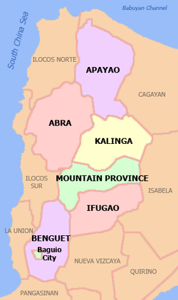
↑"Executive Order No. 220; Creating a Cordillera Administrative Region, Appropriating Funds Therefor and for Other Purposes". The LawPhil Project. Manila, Philippines. July 15, 1987. Retrieved July 29, 2016. Sec. 2. Territorial Coverage. For purposes of the CAR, the region shall consist of the provinces of Abra, Benguet, Ifugao, Kalinga-Apayao and Mt. Province and the chartered city of Baguio. Until otherwise provided by the Cordillera Executive Board (CEB), the seat of the CAR shall be Baguio City.
This page is based on this Wikipedia article Text is available under the CC BY-SA 4.0 license; additional terms may apply. Images, videos and audio are available under their respective licenses.