This article needs additional citations for verification .(January 2014) |
Lubuagan | |
---|---|
Municipality of Lubuagan | |
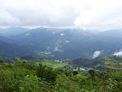
![]() Lubuagan from the Magmag-an Pass | |
![]() Map of Kalinga with Lubuagan highlighted | |
Location within the Philippines | |
Coordinates: 17°21′N121°11′E / 17.35°N 121.18°E | |
Country | Philippines |
Region | Cordillera Administrative Region |
Province | Kalinga |
District | Lone district |
Founded | 1905 |
Barangays | 9 (see Barangays) |
Government | |
• Type | Sangguniang Bayan |
• Mayor | Joel B. Tagaotao |
• Vice Mayor | Alonzo C. Saclag Jr. |
• Representative | Allen Jesse C. Mangaoang |
• Municipal Council | Members |
• Electorate | 9,890 voters (2025) |
Area | |
• Total | 234.20 km2 (90.43 sq mi) |
Elevation | 820 m (2,690 ft) |
Highest elevation | 1,880 m (6,170 ft) |
Lowest elevation | 348 m (1,142 ft) |
Population (2024 census) [3] | |
• Total | 8,660 |
• Density | 37/km2 (96/sq mi) |
• Households | 1,982 |
Economy | |
• Income class | 4th municipal income class |
• Poverty incidence | 7.52 |
• Revenue | ₱ 144 million (2022) |
• Assets | ₱ 362.7 million (2022) |
• Expenditure | ₱ 89.35 million (2022) |
• Liabilities | ₱ 292.7 million (2022) |
Service provider | |
• Electricity | Kalinga - Apayao Electric Cooperative (KAELCO) |
Time zone | UTC+8 (PST) |
ZIP code | 3802 |
PSGC | |
IDD : area code | +63 (0)74 |
Native languages | Ilocano Tagalog |
Website | www |
Lubuagan, officially the Municipality of Lubuagan is a municipality in the province of Kalinga, Philippines. According to the 2020 census, it has a population of 9,323 people. [5]
Lubuagan served as the seat of the National Government from March 6 to May 17, 1900, during the time of Gen. Emilio Aguinaldo. It is located at 800 metres (2,600 ft) above sea level in the southern part of Kalinga and in the heart of the Cordillera. It has a land area of 23,420 hectares (57,900 acres).
Spanish Rule was never established in Lubuagan during its 300 year occupation of the Philippines. However, Emilio Aguinaldo, president of the erstwhile First Philippine Republic made Lubuagan the seat of government for 73 days, from 6 March to 18 May 1900, before his escape and eventual capture at Palanan, Isabela, on 23 March 1901. [6] [7]
Upon the assumption of the United States of America as colonial power over the Philippines, the Township of Lubuagan was established in 1905 and administered via the sub provincial government of Lepanto-Bontoc sub-province. Lt. Governor E. A. Eckman, an American ex-soldier was the Chief Executive of the sub-province.
In 1907, Kalinga was separated and organized as a distinct sub-province from Lepanto-Bontoc. Franklin Walter Hale was appointed the first Lt. Governor to establish a civil government in Kalinga. Hale initially established his office in Bulanao, but moved to Lubuagan in 1909 following an outbreak of cholera and malaria. Hale whom the people baptized and fondly called Sapao, first organized his police contingent from and among the tribal pangats and headmen from the different villages of Kalinga to help them tame recalcitrant natives.
Hale served Kalinga up to the end of July 1915. He was replaced by Samuel Kane, who served for a brief period and was replaced by Alex Gilfilan in September 1916, who was later on replaced by Deputy Governor Thomas Blanco, a Filipino. In 1924, Nicasio Balinag took over as Deputy Governor.
The colonial government notably beginning with the administration of Hale up to the Commonwealth government was considered the golden years of Lubuagan, which was designated the capital town of the sub-province before Tabuk rose to its present status as the center of learning and government activities. Lubuagan at that time was the center of education, culture, commerce and trade. The founding of the Kalinga Academy in 1927, a secondary school run by American Missionaries and the St. Teresita's School in 1929, a Catholic Primary and High School managed by the CICM Belgian Missionaries bolstered the luster of Lubuagan. It was also in Lubuagan where the first instruction of higher learning in the old Mountain Province was established.
During World War II, Japanese forces occupied Lubuagan in May 1942.
In 1945, Lubuagan was bombed by American planes resulting in the destruction of the Lubuagan Central School which was then occupied by the Japanese. St. Peter's church, its convent and two more buildings within its compound were all burned to the ground.
Lubuagan is situated 6.44 kilometres (4.00 mi) from the provincial capital Tabuk, and 471.88 kilometres (293.21 mi) from the country's capital city of Manila.
Lubuagan is politically subdivided into 9 barangays. Each barangay consists of puroks and some have sitios.
Climate data for Lubuagan, Kalinga | |||||||||||||
---|---|---|---|---|---|---|---|---|---|---|---|---|---|
Month | Jan | Feb | Mar | Apr | May | Jun | Jul | Aug | Sep | Oct | Nov | Dec | Year |
Mean daily maximum °C (°F) | 21 (70) | 22 (72) | 25 (77) | 27 (81) | 27 (81) | 27 (81) | 26 (79) | 26 (79) | 25 (77) | 24 (75) | 23 (73) | 21 (70) | 25 (76) |
Mean daily minimum °C (°F) | 16 (61) | 16 (61) | 17 (63) | 18 (64) | 20 (68) | 20 (68) | 20 (68) | 20 (68) | 20 (68) | 19 (66) | 18 (64) | 17 (63) | 18 (65) |
Average precipitation mm (inches) | 78 (3.1) | 60 (2.4) | 49 (1.9) | 51 (2.0) | 194 (7.6) | 197 (7.8) | 209 (8.2) | 226 (8.9) | 185 (7.3) | 180 (7.1) | 143 (5.6) | 183 (7.2) | 1,755 (69.1) |
Average rainy days | 15.6 | 12.5 | 11.8 | 12.5 | 21.0 | 23.3 | 25.2 | 26.1 | 22.6 | 17.1 | 16.7 | 19.6 | 224 |
Source: Meteoblue [8] |
Year | Pop. | ±% p.a. |
---|---|---|
1918 | 8,874 | — |
1939 | 7,366 | −0.88% |
1948 | 7,821 | +0.67% |
1960 | 10,289 | +2.31% |
1970 | 7,236 | −3.45% |
1975 | 7,780 | +1.46% |
1980 | 8,545 | +1.89% |
1990 | 9,189 | +0.73% |
1995 | 9,897 | +1.40% |
2000 | 9,875 | −0.05% |
2007 | 10,183 | +0.42% |
2010 | 9,369 | −2.99% |
2015 | 8,733 | −1.33% |
2020 | 9,323 | +1.39% |
2024 | 8,660 | −1.76% |
Source: Philippine Statistics Authority [9] [10] [11] [12] [13] |
In the 2020 census, the population of Lubuagan was 9,323 people, [14] with a density of 40 inhabitants per square kilometre or 100 inhabitants per square mile.
Poverty incidence of Lubuagan
10 20 30 40 50 60 70 2000 62.12 2003 50.37 2006 35.60 2009 24.80 2012 26.14 2015 26.60 2018 20.23 2021 7.52 Source: Philippine Statistics Authority [15] [16] [17] [18] [19] [20] [21] [22] |
Lubuagan, belonging to the lone congressional district of the province of Kalinga, is governed by a mayor designated as its local chief executive and by a municipal council as its legislative body in accordance with the Local Government Code. The mayor, vice mayor, and the councilors are elected directly by the people through an election which is being held every three years.
Position | Name |
---|---|
Congressman | Allen Jesse C. Mangaoang |
Mayor | Charisma Anne O. Dickpus |
Vice-Mayor | Victor D. Dickly |
Councilors | Loralei T. Balangcod |
Jan Jericho A. Odiem | |
Rudy D. Ocan | |
Jayharley B. Duguiang | |
Stephen Custer B. Canao | |
Delia A. Alunday | |
Balmaceda K. Salicanto | |
Rustom B. Dao-in | |
The Lubuagan Schools District Office governs all educational institutions within the municipality. It oversees the management and operations of all private and public, from primary to secondary schools. [24]