Pasil

Last updated
Pasil
Municipality of Pasil
PasilRiverValley81023acg.jpg
Pasil River Valley
Flag of Pasil, Kalinga.png
Ph locator kalinga pasil.png
Map of Kalinga with Pasil highlighted
OpenStreetMap
Pasil
Philippines location map (square).svg
Red pog.svg
Pasil
Location within the Philippines
Coordinates: 17°23′22″N121°09′35″E / 17.3894°N 121.1597°E / 17.3894; 121.1597
Country Philippines
Region Cordillera Administrative Region
Province Kalinga
District Lone district
Barangays 14 (see Barangays)
Government
[1]
  Type Sangguniang Bayan
   Mayor Alfredo B. Malannag Jr.
   Vice Mayor Venancio O. Magangat
   Representative Allen Jesse C. Mangaoang
   Municipal Council
Members
  • Nick C. Bommogas
  • Jhomel B. Gayagay
  • Ronaldo G. Gumabay
  • Peter M. Andomang
  • Billy B. Lingayo Jr.
  • Guillermo M. Tao-il
  • Eugene M. Batalao
  • Christopher B. Canao
   Electorate 7,592 voters (2025)
Area
[2]
  Total
189.00 km2 (72.97 sq mi)
Elevation
971 m (3,186 ft)
Highest elevation
2,000 m (7,000 ft)
Lowest elevation
357 m (1,171 ft)
Population
 (2024 census) [3]
  Total
10,690
  Density57/km2 (150/sq mi)
   Households
2,066
Economy
   Income class 5th municipal income class
   Poverty incidence
11.69
% (2021) [4]
   Revenue 137.4 million (2022)
   Assets 238.4 million (2022)
   Expenditure 100.3 million (2022)
   Liabilities 118.4 million (2022)
Service provider
  ElectricityKalinga - Apayao Electric Cooperative (KAELCO)
Time zone UTC+8 (PST)
ZIP code
3803
PSGC
IDD : area code +63(0)74
Native languages Kalinga
Ilocano
Tagalog
Website www.pasil.gov.ph

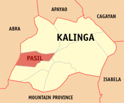
Pasil, officially the Municipality of Pasil, is a municipality in the southwestern part of the Kalinga. It is bounded on the north by the municipality of Balbalan, on the south by the municipality of Tinglayan, on the east by Tabuk, and on the west by the province of Abra and south-western part of the municipality of Sadanga, Mountain Province. According to the 2020 census, it has a population of 10,577 people. [5]

Contents

Geography

Pasil is situated 51.39 kilometres (31.93 mi) from the provincial capital Tabuk, and 516.83 kilometres (321.14 mi) from the country's capital city of Manila.

Barangays

Pasil is politically subdivided into 14 barangays. [6] Each barangay consists of puroks and some have sitios.

  • Ableg
  • Bagtayan
  • Balatoc
  • Balenciagao Sur
  • Balinciagao Norte
  • Cagaluan
  • Colayo
  • Dalupa
  • Dangtalan
  • Galdang (Casaloan)
  • Guina-ang (Poblacion)
  • Magsilay
  • Malucsad
  • Pugong

Climate

Climate data for Pasil, Kalinga
MonthJanFebMarAprMayJunJulAugSepOctNovDecYear
Mean daily maximum °C (°F)21
(70)
23
(73)
24
(75)
26
(79)
26
(79)
25
(77)
24
(75)
24
(75)
24
(75)
24
(75)
23
(73)
21
(70)
24
(75)
Mean daily minimum °C (°F)14
(57)
15
(59)
16
(61)
17
(63)
19
(66)
19
(66)
19
(66)
19
(66)
19
(66)
17
(63)
16
(61)
15
(59)
17
(63)
Average precipitation mm (inches)23
(0.9)
28
(1.1)
33
(1.3)
64
(2.5)
232
(9.1)
242
(9.5)
258
(10.2)
266
(10.5)
245
(9.6)
201
(7.9)
87
(3.4)
69
(2.7)
1,748
(68.7)
Average rainy days8.38.010.815.223.726.127.025.823.517.313.712.1211.5
Source: Meteoblue [7]

Demographics

Population census of Pasil
YearPop.±% p.a.
1970 5,557    
1975 6,755+3.99%
1980 6,872+0.34%
1990 7,572+0.97%
1995 8,935+3.15%
2000 9,360+1.00%
2007 10,084+1.03%
2010 9,626−1.68%
2015 9,644+0.04%
2020 10,577+1.96%
2024 10,690+0.26%
Source: Philippine Statistics Authority [8] [9] [10] [11] [12]

In the 2020 census, the population of Pasil was 10,577 people, [13] with a density of 56 inhabitants per square kilometre or 150 inhabitants per square mile.

Economy

Poverty incidence of Pasil

10
20
30
40
50
60
70
80
2000
61.91
2003
70.01
2006
44.80
2009
26.52
2012
41.18
2015
27.68
2018
18.15
2021
11.69

Source: Philippine Statistics Authority [14] [15] [16] [17] [18] [19] [20] [21]

Government

Local government

Pasil, belonging to the lone congressional district of the province of Kalinga, is governed by a mayor designated as its local chief executive and by a municipal council as its legislative body in accordance with the Local Government Code. The mayor, vice mayor, and the councilors are elected directly by the people through an election which is being held every three years.

Elected officials

Members of the Municipal Council
(2019–2022) [22]
PositionName
CongressmanAllen Jesse C. Mangaoang
MayorAlfredo B. Malannag Jr.
Vice-MayorTheodoro A. Mosing
CouncilorsMarlo P. Bagni
Robert Bilarmino D. Ganito
Speedy D. Lapaddic
Shirley T. Taclawan
Washington B. Bakidan
Cecilia C. Bawagan
Leonardo A. Banatao
Ronnie B. Bawalan

Folklore

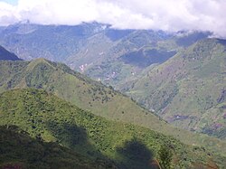
In an earlier time, Kabunian–the supreme deity of the Kalinga–left a drop of water upon an ancient tree he passed on one of his travels. This drop trickled down and with a great force akin to magnetism, attracted nearby brooks and rivulets to form what is now the Pasil River. [23]

Education

The Pasil Schools District Office governs all educational institutions within the municipality. It oversees the management and operations of all private and public, from primary to secondary schools. [24]

Primary and elementary schools

  • Ableg Elementary School
  • Bagtayan Elementary School
  • Balatoc Elementary School
  • Batong Buhay Elementary School
  • Balinciagao Elementary School
  • Balinciagao Elementary School - Wagas Primary School Annex
  • Cagaluan Elementary School
  • Cagaluan Elementary School Annex (Da-o Primary School)
  • Cagaluan Elementary School Annex (Putao Primary School)
  • Colayo Elementary School
  • Dalupa Elementary School
  • Dangtalan Elementary School
  • Galdang Elementary School
  • Magsilay Elementary School
  • Pasil Central School
  • Pasil Central School (Guinaang Annex)
  • Pasil Central School (Malucsad Annex)
  • Pasil Central School ( Pugong Annex)
  • Balinciagao Elementary School - Limood Annex

Secondary schools

References

  1. Municipality of Pasil | (DILG)
  2. "2015 Census of Population, Report No. 3 – Population, Land Area, and Population Density" (PDF). Philippine Statistics Authority. Quezon City, Philippines. August 2016. ISSN   0117-1453. Archived (PDF) from the original on May 25, 2021. Retrieved July 16, 2021.
  3. "2024 Census of Population (POPCEN) Population Counts Declared Official by the President". Philippine Statistics Authority. 17 July 2025. Retrieved 18 July 2025.
  4. "PSA Releases the 2021 City and Municipal Level Poverty Estimates". Philippine Statistics Authority. 2 April 2024. Retrieved 28 April 2024.
  5. "2024 Census of Population (POPCEN) Population Counts Declared Official by the President". Philippine Statistics Authority. 17 July 2025. Retrieved 18 July 2025.
  6. "Pasil municipality". Philippine Standard Geographic Code Interactive. Retrieved on 2011-12-20.
  7. "Pasil: Average Temperatures and Rainfall". Meteoblue. Retrieved 8 March 2020.
  8. "2024 Census of Population (POPCEN) Population Counts Declared Official by the President". Philippine Statistics Authority. 17 July 2025. Retrieved 18 July 2025.
  9. Census of Population (2015). "Cordillera Administrative Region (CAR)". Total Population by Province, City, Municipality and Barangay. Philippine Statistics Authority . Retrieved 20 June 2016.
  10. Census of Population and Housing (2010). "Cordillera Administrative Region (CAR)" (PDF). Total Population by Province, City, Municipality and Barangay. National Statistics Office . Retrieved 29 June 2016.
  11. Censuses of Population (1903–2007). "Cordillera Administrative Region (CAR)". Table 1. Population Enumerated in Various Censuses by Province/Highly Urbanized City: 1903 to 2007. National Statistics Office.
  12. "Province of". Municipality Population Data. Local Water Utilities Administration Research Division. Retrieved 17 December 2016.
  13. "2024 Census of Population (POPCEN) Population Counts Declared Official by the President". Philippine Statistics Authority. 17 July 2025. Retrieved 18 July 2025.
  14. "Poverty incidence (PI):". Philippine Statistics Authority. Retrieved December 28, 2020.
  15. "Estimation of Local Poverty in the Philippines" (PDF). Philippine Statistics Authority. 29 November 2005.
  16. "2003 City and Municipal Level Poverty Estimates" (PDF). Philippine Statistics Authority. 23 March 2009.
  17. "City and Municipal Level Poverty Estimates; 2006 and 2009" (PDF). Philippine Statistics Authority. 3 August 2012.
  18. "2012 Municipal and City Level Poverty Estimates" (PDF). Philippine Statistics Authority. 31 May 2016.
  19. "Municipal and City Level Small Area Poverty Estimates; 2009, 2012 and 2015". Philippine Statistics Authority. 10 July 2019.
  20. "PSA Releases the 2018 Municipal and City Level Poverty Estimates". Philippine Statistics Authority. 15 December 2021. Retrieved 22 January 2022.
  21. "PSA Releases the 2021 City and Municipal Level Poverty Estimates". Philippine Statistics Authority. 2 April 2024. Retrieved 28 April 2024.
  22. "2019 National and Local Elections" (PDF). Commission on Elections. Retrieved March 13, 2022.
  23. "Pasil Municipal Profile". NERBAC Cordillera Administrative Region. Retrieved on 2011-12-20.
  24. "Masterlist of Schools" (PDF). Department of Education. January 15, 2021. Retrieved May 13, 2025.