The name "Natonin" was first recorded by American Thomasites.[6] Local oral tradition provides three primary theories for the name's origin:
Matongnin: A place located on the outskirts of the town center. It can be possible that the Americans got it from a native calling that specific place by its name on their first interactions. [6]
Tongnin: Derived from the local word for "chilly" or "cold," where the phrase magtongnin means "it is cold."[6]
Mattomnin: A Balangao term literally meaning "eating of cold rice," potentially originating from an invitation to share a meal of breakfast rice.[6]
History
The early settlers of Natonin consisted of hunting and farming tribes who inhabited the region prior to the Spanish colonization of the Philippines.[6] Evidence of their early occupation includes the vast rice terraces carved into mountain slopes using only wooden tools.[6]
Historically, Natonin served as a central agricultural hub, supplying rice to neighboring tribes in Tanudan to the north, Barlig to the west, and Mayoyao to the south.[6] The discovery of ancient Chinese porcelain jars in local households suggests a history of trade ties or shared lineage with ethnic Chinese traders during the pre-colonial era.[6]
Ethnogenesis and Tribal Identity
Natonin is historically characterized by the presence of four distinct ethno-linguistic groups: the i-Ferangaos (Balangao), i-Ha’ki, i-Majukayongs (Madukayan Kalinga), and i-Kachacrans.[6]
Contrary to popular narratives suggesting the Balangao are descendants of Bontoc or Kalinga intermarriage, linguistic evidence supports a distinct "in situ" development in the Natonin region.[7] Under the Proto-Nuclear Cordilleran Hypothesis, the Balangao language is classified as a primary branch of the Nuclear Cordilleran group, suggesting it developed from a common ancestor alongside, rather than from, neighboring groups.[7]
The inclusion of the i-Majukayongs within the Natonin social fabric further illustrates the area's role as a historical crossroads between the Mountain Province and Kalinga territories, maintaining a unique identity separate from the major centers of those provinces.[6] The peace pacts and peaceful co-existence within the 4 groups paved way for intermarriages in the past years.
Geography
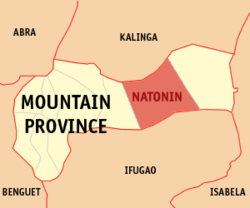
The Municipality of Natonin is bordered by Kalinga to the north, Paracelis to the east, Barlig to the west, and Ifugao to the south. The barangays are mostly carved at the foot of the mountains along which the now National Highway was carved with the exception Barangay Maducayan and some far-flung sitios of Barangay Banawel.
Natonin is situated 73.70 kilometres (45.80mi) from the provincial capital Bontoc, and 431.85 kilometres (268.34mi) from the country's capital city of Manila.
Barangays
Natonin is politically subdivided into 11 barangays. Each barangay consists of puroks and some have sitios.
The locals of Natonin are generally called iNatonin. By ethnolinguistics, the majority of the locals belong to the tribe Balangaos, or Iferangao, and speak the Finerangao language. There are three indigenous ethnic group with ancestral domains in Natonin: Balangao, Majukayong Kalinga, and eKachakran.
Hakki, who inhabit the western part of the municipality, namely the barangays of Tonglayan and Alunogan (including Pudo)
Balangao, who inhabit most of central barangays of Natonin, namely: Balangao, Botac, Santa Isabel and Banawel. [14]
Majukayong Kalinga
A part of the Kalinga tribe group, their ancestral domains are in the barangays of Maducayan and Saliok. The iMajukayongs are closely related to the Tanudan tribes of Tanudan, Kalinga, and speak the iMajukayong dialect which has similarities to the dialects of the iKalingas. [15]
Ekachakran
The homeland of the eKachakrans are in the Kadaclan barangays of Barlig: Chupac, Lunas, Kaleo, Ogo-og and Barangay Banao of Natonin. [16]
The three, while distinct in language and ethnicity, share some similarities in culture, either through borrowing or influence between the two. Populations of the town are of Igorot lineage. Headhunting was practiced throughout Natonin as late as the mid-1930s, but was set aside in favor of Christianity and education after World War II.
Languages
Natonin is home to two indigenous languages which have existed there since before the arrival of the Spanish: the Balangaw language, the Kachakran dialect of Finallig, and the Majukayong language. Because of the use of Ilocano for inter-tribal communication with other Igorot groups and as a lingua franca in Northern Luzon, the Balangaos can speak Ilocano.
The primary crop is rice, although limited arable space, mechanization and innovative agriculture renders the harvest to a subsistence level only. Backyard piggery mostly produce the pork supply. Vegetable gardening, fruit tree growing and tilapia raising are also starting to see commercial viability. Whatever is of shortage or lacking are imported outside the municipality. Few local handicrafts are promoted and are only made to order.
Natonin, belonging to the lone congressional district of the province of Mountain Province, is governed by a mayor designated as its local chief executive and by a municipal council as its legislative body in accordance with the Local Government Code. The mayor, vice mayor, and the councilors are elected directly by the people through an election which is being held every three years.
A truck traveling along the Natonin-Paracelis Road.
Since the widening of the national highways started in 2010, the Paracelis-Natonin Road is paved now. Although, some parts are either eroded or slipping away, and during rainy seasons landslides can render the roads impassable. Public utility or for-hire vans are the easiest transportation either to and from the municipality (e.g. Baguio and Manila).
Tourism
Though it's not yet that improved, Natonin has the following sites:
The Legendary Silent Mountain of Finaratan, located in Barangay Maducayan.
The Apatan Rice Terraces
The Balococ Waterfall
The Naropaan Waterfall
Tonglayan Rice Terraces
Lagan River in Balangao
Penadna Waterfalls
Lettalet Waterfalls
Fuyoun Spring in Siffu River located in Brgy. Saliok
Elephant Head located in Banao
Education
The Natonin Schools District Office governs all educational institutions within the municipality. It oversees the management and operations of all private and public, from primary to secondary schools.[26]
↑Shetler, Joanne (1976). Notes on Balangao grammar. Language Data: Asian-Pacific Series No. 9. Huntington Beach: Summer Institute of Linguistics.
↑Himes, Ronald S. (1997). "Reconstructions in Kalinga-Itneg". Oceanic Linguistics. 36 (1): 102–134. doi:10.2307/3623072. JSTOR3623072.
↑Zigzag Weekly (2024-11-16). "Kadaclan indigenous story". Zigzag Weekly. Baguio City. Retrieved 2026-02-26. Banao, a barangay of Natonin but part of Kadaclan Ancestral Domain wher "e-Kachacran" dominate the inhabitants.
This page is based on this Wikipedia article Text is available under the CC BY-SA 4.0 license; additional terms may apply. Images, videos and audio are available under their respective licenses.