₱38.83 million (2012), 43.23 million (2013), 45.15 million (2014), 6.079 million (2015), 56.69 million (2016), 63.2 million (2017), 94.53 million (2018), 82.66 million (2019)
₱40.26 million (2012), 14.15 million (2013), 16.92 million (2014), 32.97 million (2015), 39.62 million (2016), 40.16 million (2017), 95.22 million (2018), 90.89 million (2019)
₱38.33 million (2012), 37.46 million (2013), 40.47 million (2014), 39.74 million (2015), 55.29 million (2016), 63 million (2017), 69.43 million (2018), 62.13 million (2019)
₱4.382 million (2012), 0.8201 million (2013), 0.552 million (2014), 0.7203 million (2015), 7.783 million (2016), 7.816 million (2017), 27.78 million (2018), 2.869 million (2019)
Boliney, officially the Municipality of Boliney (Ilocano: Ili ti Boliney; Filipino: Bayan ng Boliney), is a municipality in the province of Abra, Philippines. According to the 2024 census, it has a population of 3,778 people.[5]
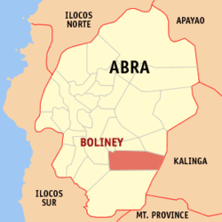
The Municipality of Boliney has a land area of 216.92 square kilometres (83.75sqmi)[6] constituting 5.21% of the 4,165.25-square-kilometre- (1,608.21sqmi) total area of Abra. It is bounded to the north by Sallapadan, Bucloc, and Daguioman, to the east by Tubo and the provinces of Kalinga and Mountain Province, and to the west by of Luba and Manabo.
Boliney is situated 52.93 kilometres (32.89mi) from the provincial capital Bangued, and 422.00 kilometres (262.22mi) from the country's capital city of Manila.
Barangays
Boliney is politically subdivided into 8 barangays.[7] Each barangay consists of puroks and some have sitios.
In the 2024 census, Boliney had a population of 3,778 people.[15] The population density was 17 inhabitants per square kilometre (44/sqmi).
The municipality's population consists of the Cordillera sub-tribes, namely Masadiit of the Tingguian Tribes, Belwang of the Igorot and Balatoc of the Kalinga tribe. Descendants of the other Tinguian sub-tribes are also represented in Boliney such as Binongan, Banao, Maeng, Ammotan (now called Muyadan of Manabo).
The main source of livelihood of the people of Boliney comes from their rice terraces. But most of their rice lands were either seriously damaged or totally lost due to the landslides, mud piles, and by the killer quakes in 1990 and 1992. They get most of their rice now from Bangued, while other mountain municipalities supplied some of the rice needs of some nearby lowland municipalities.
Rehabilitation have been on the communal facilities such as roads, trails, irrigation systems, footbridges and rice fields by the Masadiit Farmers Cooperative Inc. (MFCI) with the fund amounting to ₱2,903 million from the Presidential Management Staff and by the Inter NGO Disaster Relief Services (INDRS) with the fund amounting C$292,516.00, ₱7 million from Oxfam.
Boliney, belonging to the lone congressional district of the province of Abra, is governed by a mayor designated as its local chief executive and by a municipal council as its legislative body in accordance with the Local Government Code. The mayor, vice mayor, and the councilors are elected directly by the people through an election which is being held every three years.
Boliney is situated 52.93 kilometres (32.89mi) from the capital town of Bangued, and can be reached by road which was completed in 1974. Prior to this, it was accessible only by hiking a 24-kilometre (15mi) long mountain trail.
After 1974, the road was extended by about 14 kilometres (8.7mi) before reaching Danac, the farthest barangay. The present-day road is now as far as the Poblacion; however, the rest of the road has been abandoned.
Education
The Boliney Schools District Office governs all educational institutions within the municipality. It oversees the management and operations of all private and public, from primary to secondary schools.[25]
This page is based on this Wikipedia article Text is available under the CC BY-SA 4.0 license; additional terms may apply. Images, videos and audio are available under their respective licenses.