Danglas Last updated January 01, 2026 Municipality in Abra, Philippines
Municipality in Cordillera Administrative Region, Philippines
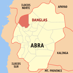
Danglas , officially the Municipality of Danglas (Ilocano : Ili ti Danglas Filipino : Bayan ng Danglas municipality in the province of Abra , Philippines . According to the 2024 census, it has a population of 4,372 people. [ 5]
Geography According to the Philippine Statistics Authority , the municipality has a land area of 156.02 square kilometres (60.24 sq mi) [ 6] constituting 3.75% of the 4,165.25-square-kilometre- (1,608.21 sq mi) total area of Abra.
Danglas is situated 14.53 kilometres (9.03 mi) from the provincial capital Bangued , and 420.37 kilometres (261.21 mi) from the country's capital city of Manila .
Climate Climate data for Danglas, Abra Month Jan Feb Mar Apr May Jun Jul Aug Sep Oct Nov Dec Year Mean daily maximum °C (°F) 29 30 32 33 32 31 30 29 30 30 30 29 30 Mean daily minimum °C (°F) 18 19 20 22 24 24 24 24 23 22 20 19 22 Average precipitation mm (inches) 9 11 13 23 92 122 153 137 139 141 42 14 896 Average rainy days 4.6 4.0 6.2 9.1 19.5 23.2 24.0 22.5 21.5 15.2 10.5 6.0 166.3 Source: Meteoblue (modeled/calculated data, not measured locally) [ 7]
Barangays Danglas is politically subdivided into 7 barangays . [ 8] Each barangay consists of puroks and some have sitios .
PSGC Barangay Population ±% p.a. 2024 [ 9] 2010 [ 10] 140106001 Abaquid 7.6% 331 423 ▾ −1.78% 140106003 Cabaruan 14.8% 648 650 ▾ −0.02% 140106004 Caupasan ( Poblacion ) 27.2% 1,189 1,398 ▾ −1.18% 140106005 Danglas 9.1% 396 479 ▾ −1.38% 140106006 Nagaparan 18.9% 827 819 ▴ 0.07% 140106007 Padangitan 9.5% 417 502 ▾ −1.35% 140106008 Pangal 6.1% 266 463 ▾ −3.97% Total 4,372 4,074 ▴ 0.52%
Demographics Population census of Danglas Year ±% p.a. 1918 2,108 — 1939 1,794 −0.77% 1948 1,738 −0.35% 1960 2,475 +2.99% 1970 2,508 +0.13% 1975 2,572 +0.51% 1980 2,657 +0.65% 1990 3,042 +1.36% 1995 4,285 +6.63% 2000 4,144 −0.71% 2007 5,411 +3.75% 2010 4,734 −4.75% 2015 4,192 −2.29% 2020 4,074 −0.60% 2024 4,372 +1.71% Source: Philippine Statistics Authority [ 11] [ 12] [ 10] [ 13] [ 14]
In the 2024 census, Danglas had a population of 4,372 people. [ 15] The population density was 28 inhabitants per square kilometre (73/sq mi) .
Government Local government Danglas, belonging to the lone congressional district of the province of Abra , is governed by a mayor designated as its local chief executive and by a municipal council as its legislative body in accordance with the Local Government Code. The mayor, vice mayor, and the councilors are elected directly by the people through an election which is being held every three years.
Elected officials Members of the Municipal Council [ 24] Position Name Congressman Joseph Santo Niño B. Bernos Mayor Denise Florence B. Bragas Vice-Mayor Esther B. Bernos Councilors Nestor B. Alcartado Jonathan H. Layugan Carmelo M. Acnam Genaro B. Alita Dominador S. Acnam Vivencio M. Bringas Herbert H. Hernandez Zenaida F. Balucas
Education The Danglas Schools District Office governs all educational institutions within the municipality. It oversees the management and operations of all private and public, from primary to secondary schools. [ 25]
Primary and elementary schools Abaquid Elementary School Danglas Central School Manganip Elementary School Nagaparan Elementary School Padangitan Elementary School Secondary school Western Abra National High School References ↑ Municipality of Danglas | (DILG) ↑ "2015 Census of Population, Report No. 3 – Population, Land Area, and Population Density" (PDF) . Philippine Statistics Authority . Quezon City, Philippines. August 2016. ISSN 0117-1453 . Archived (PDF) from the original on May 25, 2021. Retrieved July 16, 2021 . ↑ "2024 Census of Population (POPCEN) Population Counts Declared Official by the President" . Philippine Statistics Authority. 17 July 2025. Retrieved 18 July 2025 . ↑ "PSA Releases the 2021 City and Municipal Level Poverty Estimates" . Philippine Statistics Authority. 2 April 2024. Retrieved 28 April 2024 . ↑ "2024 Census of Population (POPCEN) Population Counts Declared Official by the President" . psa.gov.ph . July 17, 2024. Retrieved November 15, 2025 . ↑ "Province:" . PSGC Interactive . Quezon City, Philippines: Philippine Statistics Authority . Retrieved 25 August 2025 . ↑ "Danglas: Average Temperatures and Rainfall" . Meteoblue. Retrieved 25 April 2020 . ↑ "Municipal: Danglas" . PSGC Interactive . Quezon City, Philippines: Philippine Statistics Authority . Retrieved 8 January 2016 . ↑ Census of Population (2020). "Cordillera Administrative Region (CAR)" . Total Population by Province, City, Municipality and Barangay . Philippine Statistics Authority . Retrieved 8 July 2021 . 1 2 Census of Population and Housing (2010). "Cordillera Administrative Region (CAR)" (PDF) . Total Population by Province, City, Municipality and Barangay . National Statistics Office . Retrieved 29 June 2016 . ↑ "2024 Census of Population (POPCEN) Population Counts Declared Official by the President" . Philippine Statistics Authority. 17 July 2025. Retrieved 18 July 2025 . ↑ Census of Population (2015). "Cordillera Administrative Region (CAR)" . Total Population by Province, City, Municipality and Barangay . Philippine Statistics Authority . Retrieved 20 June 2016 . ↑ Censuses of Population (1903–2007). "Cordillera Administrative Region (CAR)" . Table 1. Population Enumerated in Various Censuses by Province/Highly Urbanized City: 1903 to 2007 National Statistics Office . ↑ "Province of" . Municipality Population Data . Local Water Utilities Administration Research Division. Retrieved 17 December 2016 . ↑ "2024 Census of Population (POPCEN) Population Counts Declared Official by the President" . Philippine Statistics Authority. 17 July 2025. Retrieved 18 July 2025 . ↑ "Poverty incidence (PI):" . Philippine Statistics Authority. Retrieved December 28, 2020 . ↑ "Estimation of Local Poverty in the Philippines" (PDF) . Philippine Statistics Authority. 29 November 2005. ↑ "2003 City and Municipal Level Poverty Estimates" (PDF) . Philippine Statistics Authority. 23 March 2009. ↑ "City and Municipal Level Poverty Estimates; 2006 and 2009" (PDF) . Philippine Statistics Authority. 3 August 2012. ↑ "2012 Municipal and City Level Poverty Estimates" (PDF) . Philippine Statistics Authority. 31 May 2016. ↑ "Municipal and City Level Small Area Poverty Estimates; 2009, 2012 and 2015" . Philippine Statistics Authority. 10 July 2019. ↑ "PSA Releases the 2018 Municipal and City Level Poverty Estimates" . Philippine Statistics Authority. 15 December 2021. Retrieved 22 January 2022 . ↑ "PSA Releases the 2021 City and Municipal Level Poverty Estimates" . Philippine Statistics Authority. 2 April 2024. Retrieved 28 April 2024 . ↑ "2019 National and Local Elections" (PDF) . Commission on Elections . Retrieved March 11, 2022 . ↑ "Masterlist of Schools" (PDF) . Department of Education . January 15, 2021. Retrieved May 7, 2025 . External links
Places adjacent to Danglas
This page is based on this
Wikipedia article Text is available under the
CC BY-SA 4.0 license; additional terms may apply.
Images, videos and audio are available under their respective licenses.