Itogon

Last updated

Itogon
Municipality of Itogon
Itogon municipal hall.gif
Municipal hall
Flag of Itogon.png
Seal of Itogon.png
Ph locator benguet itogon.png
Map of Benguet with Itogon highlighted
OpenStreetMap
Itogon
Philippines location map (square).svg
Red pog.svg
Itogon
Location within the Philippines
Coordinates: 16°22′N120°40′E / 16.37°N 120.67°E / 16.37; 120.67
Country Philippines
Region Cordillera Administrative Region
Province Benguet
District Lone district
Founded May 15, 1951
Barangays 9 (see Barangays)
Government
[1]
  Type Sangguniang Bayan
   Mayor Bernard Waclin
   Vice Mayor Dante Alain Xavier “DAX” D. Godio
   Representative Eric Yap
   Electorate 33,361 voters (2025)
Area
[2]
  Total
449.73 km2 (173.64 sq mi)
Elevation
1,003 m (3,291 ft)
Highest elevation
1,671 m (5,482 ft)
Lowest elevation
404 m (1,325 ft)
Population
 (2024 census) [3]
  Total
59,736
  Density130/km2 (340/sq mi)
   Households
15,209
Economy
   Income class 1st municipal income class
   Poverty incidence
14.44
% (2021) [4]
   Revenue 486.5 million (2022)
   Assets 1,898 million (2022)
   Expenditure 359.8 million (2022)
   Liabilities 323.2 million (2022)
Service provider
  ElectricityBenguet Electric Cooperative (BENECO)
Time zone UTC+8 (PST)
ZIP code
2604
PSGC
IDD : area code +63(0)74
Native languages Kankanay language family
Ibaloi
I-Wak
Ilocano
Tagalog
Website www.itogon.gov.ph

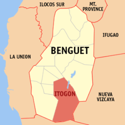
Itogon, officially the Municipality of Itogon, (Ilocano : Ili ti Itogon; Tagalog : Bayan ng Itogon), is a municipality in the province of Benguet, Philippines. According to the 2020 census, it has a population of 61,498 people. [5]

Contents

Itogon is a mining town, being the site of the first large-scale mining operations in the country. [6] [7] [8]

Itogon is also the site of Binga Dam, [9] managed and operated by the SN Aboitiz Power - Benguet, Inc.[ citation needed ]

History

Spanish period

During the Spanish Regime, a native of the historic pueblo of Itogon (or Itokhon), named Codeng, was appointed by the Spanish authorities as capitan of another nearby village, Balingway (currently Itogon Central/Proper [10] ). [7] [8] Balingway was later established as a town site and renamed after Codeng's native place. [7]

American period

During the American rule, Itogon was established as one of the 19 townships of the province of Benguet, upon the issuance of Act No. 48 by the Philippine Commission on November 22, 1900. [7] [11] [12]

Mining operations started in Itogon in 1903, after Benguet Corporation, the Philippines' first mining firm, was established in the town under the name, Benguet Consolidated Mining Company (BCMC), by Americans Nelson Peterson and Harry Clyde. [6] [13]

On August 13, 1908, Benguet was established as a sub-province of the newly created Mountain Province with the enactment of Act No. 1876. As a result, six townships of Benguet were abolished, but Itogon remained a constituent town of Benguet sub-province. [12]

World War II

Guerrilla forces in Northern Luzon launch a successful attack on the Itogon Mining District on October 15, 1942, drawing Japanese attention. This results in the Japanese pouring more troops in Luzon Island.

Post-war era

In 1948, plans by the National Power Corporation (NAPOCOR) for a second dam construction along the Agno River in the province of Benguet started, after the Ambuklao Dam construction commenced in Bokod. Bulldozers started clearing the forested area of the Guissit Mountains in 1954 for the Binga Dam. Construction of the dam took 3 years and 9 months, from August 1956 until its formal operations opening in May 1960. [8] [9]

On May 15, 1951, the town was converted into a regular municipality from the former municipal district of the same name, with the enactment of Republic Act No. 616. [14]

On June 18, 1966, the sub-province of Benguet was separated from the old Mountain Province and was converted into a regular province. Itogon remained to be a component municipality of the newly established province. [12] [15]

Geography

A forest in Mount Ulap Mt Ulap - Itogon, Benguet.jpg
A forest in Mount Ulap

The Municipality of Itogon is located at 16°22′N120°40′E / 16.37°N 120.67°E / 16.37; 120.67 , at the southeast end of the Benguet, forming a border with the provinces of Nueva Vizcaya (on the east) and Pangasinan (on the south). The town is bounded by Baguio and the municipality of Tuba on the west, La Trinidad and Tublay on the north-west, Bokod on the north-east, Kayapa and Santa Fe on the southeast, San Manuel and San Nicolas on the south, and Sison on the south-west.

According to the Philippine Statistics Authority, the municipality has a land area of 449.73 square kilometres (173.64 sq mi) [16] constituting

Itogon is situated 21.74 kilometres (13.51 mi) from the provincial capital La Trinidad, and 255.01 kilometres (158.46 mi) from the country's capital city of Manila.

Barangays

Itogon is politically subdivided into 9 barangays. [17] Each barangay consists of puroks and some have sitios.

An outcrop of metamorphosed basalt (greenschist) in barangay Tinungdan Dalupirip schist 01.jpg
An outcrop of metamorphosed basalt (greenschist) in barangay Tinungdan
PSGC Barangay Population ±% p.a.
2024 [18] 2010 [19]
141106001 Ampucao 18.3% 10,924 10,450 0.31%
141106002 Dalupirip 4.8% 2,862 2,578 0.74%
141106003 Gumatdang 2.9% 1,709 1,895 −0.72%
141106004 Loacan 14.0% 8,378 7,714 0.58%
141106005 Poblacion (Central) 7.1% 4,221 3,267 1.82%
141106006 Tinongdan 6.1% 3,646 4,216 −1.02%
141106007 Tuding 17.1% 10,211 7,703 2.00%
141106008 Ucab 14.6% 8,751 7,870 0.75%
141106009 Virac 18.1% 10,796 10,267 0.35%
Total59,73661,498−0.20%

Climate

Climate data for Itogon, Benguet
MonthJanFebMarAprMayJunJulAugSepOctNovDecYear
Mean daily maximum °C (°F)25
(77)
26
(79)
28
(82)
29
(84)
27
(81)
26
(79)
25
(77)
24
(75)
25
(77)
25
(77)
26
(79)
26
(79)
26
(79)
Mean daily minimum °C (°F)15
(59)
16
(61)
17
(63)
19
(66)
20
(68)
20
(68)
20
(68)
20
(68)
19
(66)
18
(64)
17
(63)
16
(61)
18
(65)
Average precipitation mm (inches)15
(0.6)
16
(0.6)
24
(0.9)
33
(1.3)
102
(4.0)
121
(4.8)
177
(7.0)
165
(6.5)
144
(5.7)
170
(6.7)
56
(2.2)
23
(0.9)
1,046
(41.2)
Average rainy days6.36.69.512.820.623.525.423.423.221.414.08.2194.9
Source: Meteoblue [20]

Demographics

Population census of Itogon
YearPop.±% p.a.
1903 29    
1918 3,167+36.74%
1939 35,179+12.15%
1948 16,970−7.78%
1960 32,742+5.63%
1970 39,834+1.98%
1975 41,081+0.62%
1980 47,605+2.99%
1990 61,773+2.64%
1995 47,781−4.70%
2000 46,705−0.49%
2007 48,778+0.60%
2010 55,960+5.13%
2015 59,820+1.28%
2020 61,498+0.58%
2024 59,736−0.70%
Source: Philippine Statistics Authority [21] [22] [19] [23] [24]

In the 2020 census, Itogon had a population of 61,498. [25] The population density was 140 inhabitants per square kilometre (360/sq mi).

Generally inhabited by 60 percent Ibalois, 40 percent Kankanaey, and other ethnicities such as the Ilocano, Itogon was the most populous municipality in the province, with a population of 61,773 in the 1990 census. Its population abruptly declined five years after as illustrated in the census of 1995. [24]

Economy

Poverty incidence of Itogon

10
20
30
40
2000
30.13
2003
19.74
2006
5.80
2009
8.94
2012
4.76
2015
6.32
2018
6.88
2021
14.44

Source: Philippine Statistics Authority [26] [27] [28] [29] [30] [31] [32] [33]

Itogon's main source of livelihood is mining. [6] Secondary to mining is agriculture. Major mining companies which operate in the town include Benguet Corporation, Philex Mining Corporation, Atok Big Wedge Mining Company (now called Atok Gold Mining Company) and Itogon Suyoc Mines. [34]

Government

Itogon, belonging to the lone congressional district of the province of Benguet, is governed by a mayor designated as its local chief executive and by a municipal council as its legislative body in accordance with the Local Government Code. The mayor, vice mayor, and the councilors are elected directly by the people through an election which is being held every three years.

Elected officials

Members of the Municipal Council
(2022–2025) [35]
PositionName
Congressman Eric Yap
MayorBernard S. Waclin
Vice-MayorDante Alain Xavier “DAX” D. Godio
CouncilorsJodea Brendalyn R. Acay-Camuyot
Norberto I. Pacio
Clint D. Galutan
Cesar A. Altiga
Jaime C. Laduan Sr.
Lison C. Latawan Jr.
Alejandro L. Palangdan
Albino A. Diego

Tourism

Alternate rendering of current seal Ph seal benguet itogon.png
Alternate rendering of current seal
Former seal of Itogon Itogon Benguet.png
Former seal of Itogon

Known tourist destination areas in Itogon include the Binga Dam in Tinongdan and Balatoc Mines Tours in Balatoc, Virac. Other tourist spots include the open pit mines in Loacan, hot spring in Dalupirip, Mount Ugo in Tinongdan, Level 1300 swimming pools in Poblacion with hot steams and bath and the mummies in Domolpos also in Tinongdan. [36] [37]

St. Joseph Heritage Church in barangay Dalupirip. St. Joseph Heritage Church, Dalupirip, Itogon, Benguet.jpg
St. Joseph Heritage Church in barangay Dalupirip.

Transportation

Highways through Itogon:

Education

There are two schools districe offices which govern all educational institutions within the municipality. They oversee the management and operations of all private and public, from primary to secondary schools. [38] These are Itogon I Schools District Office, and Itogon II Schools District Office.

Public schools

As of 2014, Itogon has 39 public elementary schools and 7 public secondary schools. [39] [40] [41]

School buildings and quadrangle of the Fianza Elementary School in Dalupirip, Itogon, Benguet. Fianza Elementary School grounds, Dalupirip, Itogon, Benguet 01.jpg
School buildings and quadrangle of the Fianza Elementary School in Dalupirip, Itogon, Benguet.

Private schools

Notes

    References

    1. Municipality of Itogon | (DILG)
    2. "2015 Census of Population, Report No. 3 – Population, Land Area, and Population Density" (PDF). Philippine Statistics Authority. Quezon City, Philippines. August 2016. ISSN   0117-1453. Archived (PDF) from the original on May 25, 2021. Retrieved July 16, 2021.
    3. "2024 Census of Population (POPCEN) Population Counts Declared Official by the President". Philippine Statistics Authority. July 17, 2025. Retrieved July 18, 2025.
    4. "PSA Releases the 2021 City and Municipal Level Poverty Estimates". Philippine Statistics Authority. April 2, 2024. Retrieved April 28, 2024.
    5. "2024 Census of Population (POPCEN) Population Counts Declared Official by the President". Philippine Statistics Authority. July 17, 2025. Retrieved July 18, 2025.
    6. 1 2 3 Cabreza, Vincent (October 20, 2012). "Country's first mine town should have been richest in PH". Philippine Daily Inquirer. Archived from the original on August 18, 2016. Retrieved November 3, 2014.
    7. 1 2 3 4 "Municipality of Itogon, Benguet". Department of the Interior and Local Government - Cordillera Administrative Region . Retrieved November 4, 2014.
    8. 1 2 3 Pungayan, Morr Tadeo (June 15, 2014). "History of Itogon: Chronology of Itogon History". Official Website of the Municipality of Itogon. Retrieved November 4, 2014.
    9. 1 2 3 "Binga Dam". National Power Corporation . NAPOCOR. Archived from the original on March 7, 2016. Retrieved November 4, 2014. Binga Dam forms an impoundment on the Agno River, approximately 19 km downstream of the Ambuklao dam, in Benguet province, northern Luzon.
    10. Gimenez, Lulu A. (1996). On the Basis of Custom and History: Land Resource Ownership and Access Rights Among the Igorot of the Itogon Mining Area. Mining Communities Development Center. p. 49. Retrieved November 4, 2014.
    11. "Facts & Figures: Benguet Province". Philippine Statistics Authority - National Statistical Coordination Board - Cordillera Administrative Region . Archived from the original on May 17, 2007. Retrieved October 9, 2014.
    12. 1 2 3 "History: Benguet Province". Province of Benguet (official website). Archived from the original on October 19, 2014. Retrieved October 9, 2014.
    13. "Weighing the cost of gold rush in Benguet". ABS-CBN News. ABS-CBN Corporation. October 16, 2008. Retrieved November 4, 2014.
    14. "R.A. No. 616: An Act to Convert the Municipal District of Itogon, Sub-province of Benguet, Mountain Province, into a Regular Municipality to be Known as the Municipality of Itogon". LawPH.com. Archived from the original on November 4, 2014. Retrieved November 4, 2014.
    15. "Republic Act No. 4695: An Act Creating the Provinces of Benguet, Mountain Province, Ifugao and Kalinga-Apayao". Chan Robles Virtual Law Library. June 18, 1966. Archived from the original on March 4, 2016. Retrieved December 12, 2016.
    16. "Province: Abra". PSGC Interactive. Quezon City, Philippines: Philippine Statistics Authority . Retrieved November 12, 2016.
    17. "Municipal: Itogon". PSGC Interactive. Quezon City, Philippines: Philippine Statistics Authority . Retrieved January 8, 2016.
    18. Census of Population (2020). "Cordillera Administrative Region (CAR)". Total Population by Province, City, Municipality and Barangay. Philippine Statistics Authority . Retrieved July 8, 2021.
    19. 1 2 Census of Population and Housing (2010). "Cordillera Administrative Region (CAR)" (PDF). Total Population by Province, City, Municipality and Barangay. National Statistics Office . Retrieved June 29, 2016.
    20. "Itogon: Average Temperatures and Rainfall". Meteoblue. Retrieved March 21, 2020.
    21. "2024 Census of Population (POPCEN) Population Counts Declared Official by the President". Philippine Statistics Authority. July 17, 2025. Retrieved July 18, 2025.
    22. Census of Population (2015). "Cordillera Administrative Region (CAR)". Total Population by Province, City, Municipality and Barangay. Philippine Statistics Authority . Retrieved June 20, 2016.
    23. Censuses of Population (1903–2007). "Cordillera Administrative Region (CAR)". Table 1. Population Enumerated in Various Censuses by Province/Highly Urbanized City: 1903 to 2007. National Statistics Office.
    24. 1 2 "Province of Abra". Municipality Population Data. Local Water Utilities Administration Research Division. Retrieved December 17, 2016.
    25. "2024 Census of Population (POPCEN) Population Counts Declared Official by the President". Philippine Statistics Authority. July 17, 2025. Retrieved July 18, 2025.
    26. "Poverty incidence (PI):". Philippine Statistics Authority. Retrieved December 28, 2020.
    27. "Estimation of Local Poverty in the Philippines" (PDF). Philippine Statistics Authority. November 29, 2005.
    28. "2003 City and Municipal Level Poverty Estimates" (PDF). Philippine Statistics Authority. March 23, 2009.
    29. "City and Municipal Level Poverty Estimates; 2006 and 2009" (PDF). Philippine Statistics Authority. August 3, 2012.
    30. "2012 Municipal and City Level Poverty Estimates" (PDF). Philippine Statistics Authority. May 31, 2016.
    31. "Municipal and City Level Small Area Poverty Estimates; 2009, 2012 and 2015". Philippine Statistics Authority. July 10, 2019.
    32. "PSA Releases the 2018 Municipal and City Level Poverty Estimates". Philippine Statistics Authority. December 15, 2021. Retrieved January 22, 2022.
    33. "PSA Releases the 2021 City and Municipal Level Poverty Estimates". Philippine Statistics Authority. April 2, 2024. Retrieved April 28, 2024.
    34. "Brief Profile of the Municipality of Itogon". Official Website of the Municipality of Itogon. Archived from the original on March 6, 2016. Retrieved November 4, 2014.
    35. "Tourism". Municipality of Itogon, Official Website. Retrieved September 19, 2014.
    36. "Local Attractions: Itogon". Province of Benguet website. Retrieved September 19, 2014.
    37. "Masterlist of Schools" (PDF). Department of Education. January 15, 2021. Retrieved May 10, 2025.
    38. "Masterlist of Public Elementary Schools for the School year 2012- 2013". Department of Education (Philippines), July 15, 2013. Archived from the original (XLSX) on March 4, 2016. Retrieved December 28, 2014.
    39. 1 2 "Masterlist of Secondary Schools (School Year 2013- 2014)". Department of Education (Philippines), 4 July 2013. Archived from the original (XLSX) on July 1, 2014. Retrieved November 20, 2014.
    40. 1 2 "Masterlist of Public Schools SY 2013-2014". Department of Education (Philippines), 22 October 2014. Archived from the original (XLSX) on April 21, 2016. Retrieved December 28, 2014.