Metro Baguio

Last updated
Metro Baguio
BLISTT
Baguio City overlooking night view (Baguio City; 02-24-2023).jpg
Skyline of Baguio City at night
Metro baguio.svg
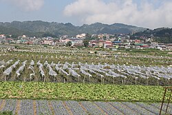
Baguio and neighboring towns which is regarded as part of Metro Baguio.
Country Philippines
Region Cordillera Administrative Region
(CAR)
Province Benguet
EstablishedApril 11, 2004
Metropolitan Center Baguio
City/Municipality
Government
[1]
  TypeCouncil
  ChairmanBenjamin Magalong
(mayor of Baguio )
  Co-ChairmanArthur Baldo
(mayor of Sablan )
  TreasurerEdna Tabanda
(mayor of La Trinidad )
  SecretaryRuben Paoad
(mayor of Tublay )
Area
  Total1,094.79 km2 (422.70 sq mi)
Elevation
500 to 1,850 m (1,500 to 6,069 ft)
Population
 (2020)
  Total644,589
  Density590/km2 (1,500/sq mi)
Time zone UTC+8 (PST)
Area Code+63 74

Metro Baguio, also known as BLISTT, is an agglomeration of the city of Baguio and five municipalities of the Philippine province of Benguet, namely: La Trinidad, Itogon, Sablan, Tuba, and Tublay.

Contents

Long proposed and supported by the NEDA-Regional Development Council-Cordillera, [2] it was previously defined between 2007 and 2017 as one of twelve metropolitan areas in the Philippines. [3] [4] The original "BLIST" long existed as a concept since its inception in August 1990, a month after the 1990 earthquake which devastated the city of Baguio and other surrounding areas, [5] and only existed as an informal reference to the area. The concept was later amended into "BLISTT" in 2009, which included the municipality of Tublay, despite not being adjacent to the city of Baguio. [5] It was officially established after a signing of a memorandum of agreement by the mayors of the component local government units. [6]

Component local government units

BLISTT, like Metro Manila and Metro Cebu, is not an administrative political unit but an agglomeration of independent local government units (LGUs), the third level government in the Philippine political system. [7]

LocationCity/MunicipalityImagePopulation
(2010) [7]
Area
(km2) [7]
Pop. density
(per km2)
Income
classification [7]
Benguet Baguio-location.png Baguio Baguio city proper overlooking cathedral (Baguio city; 12-04-2022).jpg 318,67657.55,5421st Class
Benguet La Trinidad-location.png La Trinidad La Trinidad strawberry fields.JPG 107,18882.741,295.481st Class
Benguet Itogon-location.png Itogon Itogon municipal hall.gif 55,960450124.41st Class
Benguet Sablan-location.png Sablan FvfSablanBenguet0262 02.JPG 10,51110699.25th Class
Benguet Tuba-location.png Tuba Tuba Benguet 1.JPG 42,874296144.841st Class
Benguet Tublay-location15.png Tublay Tublay town hall (Tublay, Benguet)(2018-11-26).jpg 16,555102.55161.4335th Class
BLISTT551,7641094.79503.9907-

History

The original BLIST concept was visualized by the key stakeholders in August 1990 after the 1990 Luzon earthquake devastated Baguio. [5] Supported by a European Union grant in 1992, the BLIST Urban Plan was completed in 1994, which aimed to reconstruct the city following the earthquake and to reduce overcrowding in the city. The concept was not supported by the component Benguet municipalities of La Trinidad, Itogon, Sablan, and Tuba such that it was prepared with little consultation, and was primarily developed for the sole convenience of Baguio. [5]

In 2009, the municipality of Tublay in the province of Benguet was included in the new BLISTT plan as revived by the Regional Development Council of the Cordillera Administrative Region (RDC-CAR). [5]

BLIST Map.png BLISTT Map.png
The original BLIST
in the province of Benguet
The new BLISTT
which includes Tublay

The concept had long been pushed through by the city government of Baguio, for the prime purpose of alleviating the city's overpopulation and decongestion problems. [8] [9] It was criticized by other government officials as heavily geared towards the alleviating of the problems of Baguio. [10]

It was officially established after a signing of a memorandum of agreement by the mayors of the component LGUs. [6] The first set of council officials were elected on February 27, 2014, with Baguio Mayor Mauricio Domogan as chairman, Sablan Mayor Arthur Baldo as co-chairman, La Trinidad Mayor Edna Tabanda as Treasurer, and Tublay Mayor Ruben Paoad as Secretary, all of whom would serve for a one-year term. [1]

Geography and climate

Geography

Most of the metropolitan area, like Baguio, is located some 1,500 meters above sea level, nestled within the Cordillera Central mountain range in northern Luzon. It covers a total area of 1094.79 square kilometers.

Climate

BLISTT features a subtropical highland climate under the Köppen climate classification. The area is known for its mild climate. Owing to its high elevation, the temperature is 8 degrees Celsius lower compared to the average temperature of the rest of the country. Average temperature ranges from 15 to 23 degrees Celsius. It is usually lower during the late and early months of the year. The lowest recorded temperature in Baguio was 6.3 degrees Celsius on January 18, 1961. This is in contrast to the all-time high of 30.4 degrees Celsius recorded on March 15, 1988, during the 1988 El Niño season. Baguio seldom exceeds 26 degrees Celsius even during the warmest part of the year. Like many other cities with a subtropical highland climate, BLISTT sees noticeably less precipitation during its “low-sun” months. The metropolitan area though sees an extraordinary amount of precipitation during its wetter months, with the months of July and August seeing on average more than 1,000 mm of rain. BLISTT averages over 4500 mm of precipitation annually. [11]

Climate data for Baguio, Philippines
MonthJanFebMarAprMayJunJulAugSepOctNovDecYear
Record high °C (°F)26
(79)
27
(81)
28
(82)
29
(84)
27
(81)
27
(80)
27
(80)
27
(80)
26
(79)
27
(81)
27
(80)
27
(80)
29
(84)
Mean daily maximum °C (°F)22
(72)
23
(73)
24
(76)
25
(77)
24
(76)
24
(75)
22
(71)
22
(71)
22
(71)
23
(73)
23
(74)
23
(74)
23
(74)
Mean daily minimum °C (°F)13
(55)
13
(56)
14
(58)
16
(60)
16
(61)
16
(61)
16
(60)
16
(60)
16
(60)
16
(60)
15
(59)
14
(57)
15
(59)
Record low °C (°F)6
(43)
8
(47)
11
(52)
10
(50)
14
(57)
12
(53)
12
(54)
13
(55)
14
(57)
11
(52)
9
(49)
8
(46)
6
(43)
Average precipitation mm (inches)22.86
(0.90)
22.86
(0.90)
43.18
(1.70)
109.2
(4.30)
401.3
(15.80)
436.9
(17.20)
1,074.4
(42.30)
1,160.8
(45.70)
713.7
(28.10)
381
(15.0)
124.5
(4.90)
50.8
(2.00)
4,541.5
(178.80)
Source: http://www.weatherbase.com/weather/weather.php3?s=082389&refer=

Government

Unlike Metro Manila, BLISTT, before the signing of the MOA, didn't have a government that directly administered the area. [5] However, on February 27, 2014, the first set of council officials were elected, with Baguio Mayor Mauricio Domogan as chairman, Sablan Mayor Arthur Baldo as co-chairman, La Trinidad Mayor Edna Tabanda as Treasurer, and Tublay Mayor Ruben Paoad as Secretary, all of whom would serve for a one-year term. [1]

Media

All Metro Baguio's Radio and Television stations, Cable and Satellite TV providers and broadcast transmitters and Local Newspapers.

AM Stations
FM Stations
TV Stations
Cable & Satellite TV Providers

Newspapers

Transportation

On land

Three main access roads lead to the city of Baguio from the lowlands; Kennon Road, Aspiras-Palispis Highway (formerly Marcos Highway), and Naguilian Road (also known as Quirino Highway). Kennon Road starts from Rosario in La Union province, and winds through a narrow, steep valley. Although perilous and being prone to landslides during rainy season, it is the fastest route to Baguio from the lowlands, and offers a scenic view. Aspiras Highway, which starts from Agoo, La Union and connects to Palispis Highway at Benguet-La Union highway border, and Naguilian Road, which starts from Bauang, La Union, are longer but safer routes than Kennon Road. For this, they are preferred by coaches, buses and lorries. All three major highways traverse the municipality of Tuba, also known as the "Gateway to Baguio". [12] [13] A significant portion of Naguilian Road covers the municipality of Sablan.

From Itogon, Baguio is connected by the Baguio-Bua-Itogon Road, while La Trinidad's main access route to the city is via the Halsema Highway (also known as the "Mountain Trail"), which leads north through the mountainous portion of the Cordillera Administrative Region. The municipality of Tublay, situated at the north of La Trinidad, is likewise traversed by the Halsema Highway.

Another access to Baguio from Aritao in the Nueva Vizcaya province passes through Itogon, but is less traveled. The road is not well-maintained, and public transportation through this route is not as regular.

Several bus lines link Baguio with Manila and the rest of the lowlands. Most transportation companies also offer express and air-conditioned buses at a much higher fare, though some minibuses offer cheaper fares. Bus services that operate in Baguio include Philippine Rabbit, Dangwa Tranco, Dagupan Bus, Pangasinan Solid North Transit. Victory Liner, Partas, Genesis, and Saulog Transit. [14] [ circular reference ]

By air

Loakan Airport is the lone airport serving the general area. The airport is classified as a trunkline airport, or a major commercial domestic airport, by the Civil Aviation Authority of the Philippines, a body of the Department of Transportation and Communications that is responsible for the operations of not only this airport but also of all other airports in the Philippines except the major international airports. It is about 10 minutes by car from the city center going south. Due to the limited length of the runway which is 1,802 meters or 5,912 feet, it is restricted to commuter size aircraft. This perhaps contributed to the city's declining competitiveness against other medium-sized cities around the country. The airport is used primarily by helicopters, turbo-prop and piston engine aircraft, although on rare occasion light business jets (LBJ) have flown into the airport.

Loakan Airport reopened on December 16, 2022, with Philippine Airlines launching the first regular commercial flight to the airport in decades to and from Mactan–Cebu International Airport on the day of the reopening. [15]

Related Research Articles

<span class="mw-page-title-main">Baguio</span> Highly urbanized city in Benguet, Philippines

Baguio, officially the City of Baguio, is a 1st class highly urbanized city in the Cordillera Administrative Region, Philippines. It is known as the "Summer Capital of the Philippines", owing to its cool climate since the city is located approximately 4,810 feet above mean sea level, often cited as 1,540 meters in the Luzon tropical pine forests ecoregion, which also makes it conducive for the growth of mossy plants, orchids and pine trees, to which it attributes its other moniker as the "City of Pines".

<span class="mw-page-title-main">Benguet</span> Province in Cordillera, Philippines

Benguet, officially the Province of Benguet, is a landlocked province of the Philippines located in the southern tip of the Cordillera Administrative Region in the island of Luzon. Its capital is La Trinidad.

<span class="mw-page-title-main">Dagupan</span> Independent component city in Pangasinan, Philippines

Dagupan, officially the City of Dagupan, is a 1st class independent component city in the Ilocos Region, Philippines. According to the 2020 census, it has a population of 174,302 people.

<span class="mw-page-title-main">La Trinidad, Benguet</span> Capital of Benguet, Philippines

La Trinidad, officially the Municipality of La Trinidad, is a 1st class municipality and capital of the province of Benguet, Philippines. According to the 2020 census, it has a population of 137,404 people.

<span class="mw-page-title-main">Atok, Benguet</span> Municipality in Benguet, Philippines

Atok, officially the Municipality of Atok,, is a 4th class municipality in the province of Benguet, Philippines. According to the 2020 census, it has a population of 19,218 people.

<span class="mw-page-title-main">Itogon</span> Municipality in Benguet, Philippines

Itogon, officially the Municipality of Itogon,, is a 1st class municipality in the province of Benguet, Philippines. According to the 2020 census, it has a population of 61,498 people.

<span class="mw-page-title-main">Sablan, Benguet</span> Municipality in Benguet, Philippines

Sablan, officially the Municipality of Sablan, is a 5th class municipality in the province of Benguet, Philippines. According to the 2020 census, it has a population of 11,588 people.

<span class="mw-page-title-main">Tuba, Benguet</span> Municipality in Benguet, Philippines

Tuba, officially the Municipality of Tuba,, is a 1st class municipality in the province of Benguet, Philippines. According to the 2020 census, it has a population of 48,312 people.

<span class="mw-page-title-main">Tublay</span> Municipality in Benguet, Philippines

Tublay, officially the Municipality of Tublay, is a 5th class municipality in the province of Benguet, Philippines. According to the 2020 census, it has a population of 19,429 people.

<span class="mw-page-title-main">Session Road</span>

Session Road is a six-lane 1.7-kilometer (1.1 mi) major road in Baguio, Philippines. The entire road forms part of National Route 231 (N231) of the Philippine highway network.

The legislative districts of Benguet are the representations of the province of Benguet in the various national legislatures of the Philippines. The province is currently represented in the lower house of the Congress of the Philippines through its lone congressional district.

<span class="mw-page-title-main">Mauricio Domogan</span>

Mauricio "Morris" Gamsao Domogan is a Filipino lawyer and politician and is the longest serving mayor of the city of Baguio. A member of the Lakas Kampi CMD party, Domogan served three terms as mayor of Baguio, initially as acting mayor from July to October 1992, and officially as the new mayor in October 1992 after succeeding the mayoralty post from Ramon Labo after he was disqualified due to his citizenship status, until 2001, and again from 2010 to 2019.

<span class="mw-page-title-main">DZET-TV</span> Television station in Benguet, Philippines

DZET-TV, Channel 28 (analog) and Channel 51 (digital), is a commercial television station owned and operated by TV5 Network, Inc. Its studio is located at Camp 7, Monticello Road, Baguio, while its transmitter is located at Mt. Sto. Tomas, Tuba, Benguet.

<span class="mw-page-title-main">Benguet Provincial Board</span> Legislative body of the province of Benguet, Philippines

The Benguet Provincial Board is the Sangguniang Panlalawigan of the Philippine province of Benguet.

<span class="mw-page-title-main">Halsema Highway</span>

The Halsema Highway is a national secondary highway in the Philippines. Situated within the Cordillera Central range in northern Luzon, it stretches from the city limit of Baguio to the municipality of Bontoc. Its highest point is at 7,400 feet (2,300 m) above sea level in the municipality of Atok. It was officially recognized as the highest altitude highway in the Philippines until 2019, when the 2.429-kilometer (7,970 ft) high point Kiangan–Tinoc–Buguias Road in Tinoc, Ifugao, was recognized as the new holder of the distinction.

The Balili River, also known as the Naguilian River, is a river in the province of Benguet on the island of Luzon, Philippines. With a total length of 62.7 km (39.0 mi), it traverses the city of Baguio, and the municipalities of La Trinidad and Sablan before entering the province of La Union, where the midstream is called the Naguilian River. It drains into the South China Sea through the town of Bauang, where the downstream is also known as Balili River.

The Benguet–Nueva Vizcaya Road,, is the road system that connects the provinces of Benguet and Nueva Vizcaya in the Philippines.

<span class="mw-page-title-main">D-8-XM-TV</span> Television station in Baguio

D-8-XM-TV known on-air as PTV Cordillera, is a television station in North Central Luzon, Philippines, a regional of Philippine-government owned television network People's Television Network. Its studio is located at the PTV Cordillera Broadcast Hub, PIA Northern Luzon Compound, Romulo Drive, Brgy. Lualhati, Baguio City and its transmitter is located at Mount Santo Tomas, Tuba, Benguet Province.

<span class="mw-page-title-main">Marquez Go</span> Filipino businessman and politician

Marquez "Mark" Ocampo Go is a Filipino businessman and politician. A member of the Nacionalista Party, he is the incumbent representative of the legislative district of Baguio since 2016. He is also an outstanding citizen of Baguio awardee in 1998.

<span class="mw-page-title-main">Lower Agno Watershed Forest Reserve</span>

The Lower Agno Watershed Forest Reserve is a Philippine protected area that straddles the Cordillera and Ilocos regions encompassing land from the provinces of Benguet and Pangasinan. Operated by the Lower Agno WFR Protected Area Management Board under the Department of Environment and Natural Resources, Lower Agno follows the Agno River corridor from the northern villages of Itogon to just north of the municipalities of San Manuel and San Nicolas. The reserve also known as the San Roque Watershed protects the mid-Agno River basin with its meandering river and short tributaries in a pine-forested mountainous terrain at the southern end of the Cordillera Central, around 30 kilometres (19 mi) southeast of Baguio. It is located in an important mining district and includes the reservoir of the San Roque Dam, the largest dam in the country and the prime source of water, hydropower and irrigation for surrounding regions in Luzon.

References

  1. 1 2 3 Toyoken, Freda. "First Set of Blistt Governing Council Officials Elected". National Economic and Development Authority - Cordillera Administrative Region. Retrieved February 1, 2015.
  2. Mercado, Ruben G.; Chammag, Carmel P. (October 1998). "Owning the Metropolitan Vision: The Case of BLIST". Discussion Papers (98–16). Philippine Institute for Development Studies . Retrieved May 28, 2023.
  3. Development Information Staff, National Economic and Development Authority (August 30, 2007). "Building Globally Competitive Metro Areas in the Philippines" (PDF). Archived from the original (PDF) on July 5, 2010. Retrieved October 21, 2010.
  4. "Chapter 3: Overlay of Economic Growth, Demographic Trends, and Physical Characteristics" (PDF). Philippine Development Plan 2017-2022. National Economic and Development Authority: 37–38. 2017. Archived from the original (PDF) on 25 July 2020. Retrieved May 28, 2023.
  5. 1 2 3 4 5 6 Liporada, Cesar. "Why BLISTT?". Baguio Midland Courier. Retrieved September 25, 2014.
  6. 1 2 Cabreza, Vincent (November 5, 2012). "Better Trade, Traffic Seen Between Baguio, Neighbors". Philippine Daily Inquirer . Retrieved February 1, 2015.
  7. 1 2 3 4 "Province: Benguet". Philippine Statistics Authority - National Statistical Coordination Board. Archived from the original on April 24, 2016. Retrieved February 1, 2015.
  8. Agreda, JM (July 6, 2012). "Metro Baguio concept pushed". Sun.Star Baguio. Retrieved September 25, 2014.
  9. See, Dexter A. (April 26, 2010). "Domogan Says BLIST Will Solve Baguio's Problems". Northern Philippine Times. Retrieved February 1, 2015.
  10. Catajan, Maria Elena (September 4, 2013). "Governor: BLISTT Should Be for True Development". Sun.Star Baguio. Retrieved February 1, 2015.
  11. Baguio#Geography and climate
  12. Galacgac, Aure (November 14, 2011). "Gateway to Baguio marks centennial". Sun.Star Baguio. Archived from the original on October 6, 2014. Retrieved October 3, 2014.
  13. Laking, Jimmy (August 10, 2014). "Tuba to clear 2-story structure blocking Bridal Veil Falls' view". Baguio Midland Courier. Archived from the original on August 7, 2016. Retrieved October 3, 2014.
  14. Baguio#Transportation
  15. Cabreza, Vincent (December 16, 2022). "Maiden flight of Baguio-Cebu route lands at Summer Capital's only airport". Inquirer. Retrieved December 16, 2022.