
Baguio, officially the City of Baguio, is a 1st class highly urbanized city in the Cordillera Administrative Region, Philippines. It is known as the "Summer Capital of the Philippines", owing to its cool climate since the city is located approximately 4,810 feet above mean sea level, often cited as 1,540 meters in the Luzon tropical pine forests ecoregion, which also makes it conducive for the growth of mossy plants, orchids and pine trees, to which it attributes its other moniker as the "City of Pines".
Benguet, officially the Province of Benguet, is a landlocked province of the Philippines located in the southern tip of the Cordillera Administrative Region in the island of Luzon. Its capital is La Trinidad.

Mountain Province is a landlocked province of the Philippines in the Cordillera Administrative Region in Luzon. Its capital is Bontoc. Mountain Province was formerly referred to as Mountain in some foreign references. The name is usually shortened by locals to Mt. Province.

The Cordillera Administrative Region, also known as the Cordillera Region and Cordillera, is an administrative region in the Philippines, situated within the island of Luzon. It is the only landlocked region in the insular country, bordered by the Ilocos Region to the west and southwest, and by the Cagayan Valley Region to the north, east, and southeast. It is the least populous region in the Philippines, with a population less than that of the city of Manila.

The Cordillera Central or Cordillera Range is a massive mountain range 320 kilometres (200 mi) long north-south and 118 kilometres (73 mi) east-west situated in the north-central part of the island of Luzon, in the Philippines. The mountain range encompasses all provinces of the Cordillera Administrative Region, as well as portions of eastern Ilocos Norte, eastern Ilocos Sur, eastern La Union, northeastern Pangasinan, western Nueva Vizcaya, and western Cagayan.

The indigenous peoples of the Cordillera in northern Luzon, Philippines, often referred to by the exonym Igorot people, or more recently, as the Cordilleran peoples, are an ethnic group composed of nine main ethnolinguistic groups whose domains are in the Cordillera Mountain Range, altogether numbering about 1.8 million people in the early 21st century.

Sagada, officially the Municipality of Sagada is a 5th class municipality in the province of Mountain Province, Philippines. According to the 2020 census, it has a population of 11,510 people.

Atok, officially the Municipality of Atok,, is a 4th class municipality in the province of Benguet, Philippines. According to the 2020 census, it has a population of 19,218 people.

Buguias, officially the Municipality of Buguias,, is a 3rd class municipality in the province of Benguet, Philippines. According to the 2020 census, it has a population of 44,877 people. The municipality is home to the mummy of Apo Anno, one of the most revered and important folk hero in Benguet prior to Spanish arrival.

Kabayan, officially the Municipality of Kabayan, is a 4th class municipality in the province of Benguet, Philippines. According to the 2020 census, it has a population of 15,806 people.

Kapangan, officially the Municipality of Kapangan,, is a 4th class municipality in the province of Benguet, Philippines. According to the 2020 census, it has a population of 19,297 people.
Kibungan, officially the Municipality of Kibungan, is a 4th class municipality in the province of Benguet, Philippines. According to the 2020 census, it has a population of 17,051 people.

Tuba, officially the Municipality of Tuba,, is a 1st class municipality in the province of Benguet, Philippines. According to the 2020 census, it has a population of 48,312 people.

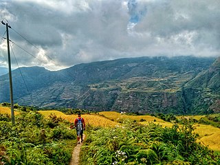
The Rice Terraces of the Philippine Cordilleras are a World Heritage Site consisting of a complex of rice terraces on the island of Luzon in the Philippines. They were inscribed on the UNESCO World Heritage List in 1995, the first-ever property to be included in the cultural landscape category of the World Heritage List. This inscription has five sites: the Batad Rice Terraces and Bangaan Rice Terraces, Mayoyao Rice Terraces, Hungduan Rice Terraces and Nagacadan Rice Terraces, all in Ifugao Province. The Ifugao Rice Terraces reach a higher altitude and were built on steeper slopes than many other terraces. The Ifugao complex of stone or mud walls and the careful carving of the natural contours of hills and mountains combine to make terraced pond fields, coupled with the development of intricate irrigation systems, harvesting water from the forests of the mountain tops, and an elaborate farming system.
The legislative districts of Mountain Province are the representations of Mountain Province in the various national legislatures of the Philippines. The province is currently represented in the lower house of the Congress of the Philippines through its lone congressional district.

Metro Baguio, also known as BLISTT, is an agglomeration of the city of Baguio and five municipalities of the Philippine province of Benguet, namely: La Trinidad, Itogon, Sablan, Tuba, and Tublay.
Tagudin–Cervantes–Sabangan Road, signed as National Route 205 (N205) of the Philippine highway network, is a 98-kilometer (61 mi) national secondary road in the Philippines that connects between the provinces of Ilocos Sur and Mountain Province.

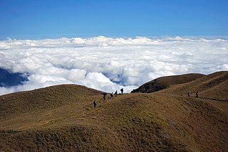
The Halsema Highroad Point is a vantage point in Atok, Benguet, Philippines. It is situated on the Halsema Highway.
The COVID-19 pandemic in the Cordillera Administrative Region is part of the worldwide pandemic of coronavirus disease 2019 caused by severe acute respiratory syndrome coronavirus 2. The virus reached the Cordillera Administrative Region on March 20, 2020, when the first case of the disease was confirmed to involve a resident of Manabo, Abra. All provinces, as well as the independent city of Baguio has recorded at least one confirmed COVID-19 case.

The Upper Agno River Basin Resource Reserve is a protected area located on the southeast flank of the Cordillera Central in the Philippine province of Benguet along its border with Ifugao and Nueva Vizcaya. It is a resource reserve located high in the Central and Polis ranges protecting the headwaters of the Agno River. According to section 4 of the National Integrated Protected Areas System Act, a resource reserve is an extensive and relatively isolated area designated as such to preserve the natural resources of the area. The reserve comprises 77,561 hectares of the catchment area that feeds the Ambuklao and Binga dams, two of the country's oldest hydroelectric plants that supply power to the city of Baguio and entire Benguet province. Upper Agno is north of and contiguous with the Lower Agno Watershed Forest Reserve that preserves the immediate downstream of the Binga Dam where the Agno River is impounded by a third dam, the San Roque Dam, the largest in the Philippines and the main source of water, electric energy and irrigation for surrounding regions in Luzon.

