Darién is a province in Panama whose capital city is La Palma. With an area of 11,896.5 km2 (4,593.3 sq mi), it is located at the eastern end of the country and bordered to the north by the province of Panamá and the region of Kuna Yala. To the south, it is bordered by the Pacific Ocean and Colombia. To the east, it borders Colombia; to the west, it borders the Pacific Ocean and the province of Panama.

Rodrigo de Bastidas was a Spanish conquistador and explorer who mapped the northern coast of South America, discovered Panama, and founded the city of Santa Marta.

Necoclí is a town and municipality in Antioquia Department, Colombia. Located on the eastern shore of the Gulf of Urabá, it is part of the Urabá Antioquia sub-region. The population is predominantly Afro-Colombian.
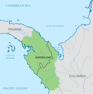
The Gulf of Darién is the southernmost region of the Caribbean Sea, located north and east of the border between Panama and Colombia. Within the gulf is the Gulf of Urabá, a small lip of sea extending southward, between Caribana Point and Cape Tiburón, Colombia, on the southern shores of which is the port city of Turbo, Colombia. The Atrato River delta extends into the Gulf of Darién.

Vasco Núñez de Balboa was a Spanish explorer, governor, and conquistador. He is best known for crossing the Isthmus of Panama to the Pacific Ocean in 1513, becoming the first European to lead an expedition to have seen or reached the Pacific from the New World.
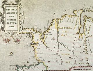
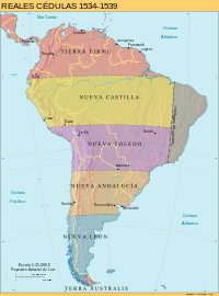
Castilla de Oro or del Oro was the name given by the Spanish settlers at the beginning of the 16th century to the Central American territories from the Gulf of Urabá, near today's Colombian-Panamanian border, to the Belén River. Beyond that river, the region was known as Veragua, and was disputed by the Spanish crown along with the Columbus family. The name "Castilla de Oro" was made official in May 1513 by King Ferdinand II of Aragon, then regent of the Crown of Castile.

Pedro de Heredia was a Spanish conquistador, founder of the city of Cartagena de Indias and explorer of the northern coast and the interior of present-day Colombia.

The Spanish conquest of New Granada refers to the conquest by the Spanish monarchy of the Chibcha language-speaking nations of modern-day Colombia and Panama, mainly the Muisca and Tairona that inhabited present-day Colombia, beginning the Spanish colonization of the Americas. It is estimated that around 5.25 million people died as a result of Spanish Conquest, either by disease or direct conflict, this is 87.5% of the Pre-Columbian population of Colombia.

The Governorate of New Castile was the gubernatorial region administered to Francisco Pizarro in 1529 by King Charles I of Spain, of which he was appointed governor.
The Governorate of New Andalusia was a Spanish Governorate of the Crown of Castile in South America which existed between 1534 and 1617.
The Royal Audience and Chancery of Panama in Tierra Firme was a governing body and superior court in the New World empire of Spain. The Audiencia of Panama was the third American audiencia after the ones of Santo Domingo and Mexico. It existed three times under various guises since it first creation in 1538 until its ultimate abolition in 1751.
The Real Audiencia of Santiago de Guatemala, simply known as the Audiencia of Guatemala or the Audiencia of Los Confines, was a Real Audiencia in the Imperial Spanish territory in Central America known as the Captaincy General of Guatemala (1609-1821). The Audiencia's presiding officer, the president, was the head of the government of the area. The Audiencia was initially created by decrees of November 20, 1542 and September 13, 1543, and had its seat in Antigua Guatemala.
The Governorate of New Toledo was a Spanish Governorate of the Crown of Castile formed from the previous southern half of the Inca Empire, stretching south into present day central Chile, and east into present day central Brazil.

A Spanish Colombian is a Colombian of full Spanish descent. Since many of Colombians are of full or partial Spanish descent and their culture is influenced by Spain as well as the Colombian government using White Colombian instead of Spanish Colombian, the term is rarely used.

The Governorate of New Andalusia was a Spanish colonial entity in what today constitutes the Caribbean coastal territories from Central America, Colombia and Venezuela, and the islands of what today are Jamaica, Cuba, Haiti, Dominican Republic and Puerto Rico. The Government of Nueva Andalucia was set in Venezuela from 1501 to 1513.

The Colombia–Panama border is the 339-kilometer-long (211 mi) international boundary between Colombia and Panama. It also splits the Darién Gap, a break across the South American and North American continents. This large watershed, forest, and mountainous area is in the north-western portion of Colombia's Chocó Department and south-eastern portion of Panama's Darién Province.

The Spanish conquest of Honduras was a 16th-century conflict during the Spanish colonization of the Americas in which the territory that now comprises the Republic of Honduras, one of the seven states of Central America, was incorporated into the Spanish Empire. In 1502, the territory was claimed for the king of Spain by Christopher Columbus on his fourth and final trip to the New World. The territory that now comprises Honduras was inhabited by a mix of indigenous peoples straddling a transitional cultural zone between Mesoamerica to the northwest, and the Intermediate Area to the southeast. Indigenous groups included Maya, Lenca, Pech, Miskitu, Mayangna (Sumu), Jicaque, Pipil and Chorotega. Two indigenous leaders are particularly notable for their resistance against the Spanish; the Maya leader Sicumba, and the Lenca ruler referred to as Lempira.
Joaquín Tellechea was an hacendado and Spanish Army sergeant major who served as the 17th mayor of Ponce, Puerto Rico, in 1821. Tellechea was a sergeant major and also owned a 90-cuerda sugar cane hacienda in the Los Caños sector in Ponce.
The Governorate of Terra Australis or Governorate of Pedro Sancho de la Hoz was a Spanish Governorate of the Crown of Castile created in 1539 which was granted to Pedro Sánchez de la Hoz and consisted in all the territories to the south of the Strait of Magellan until the South Pole, and, to the east and west, the borders were the ones specified in the treaties of Tordesillas and Zaragoza, respectively.

The coastal 'fortifications' of Spain in America are the works of military engineering that bear witness to the four hundred years of Spanish presence in America. They were built from northern California to Tierra del Fuego. Their purpose was the defense of port towns against the attack of the fleets of the English, French and Dutch armies, as well as corsairs and pirates.