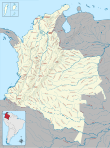
The Republic of Colombia is situated largely in the north-west of South America, with some territories falling within the boundaries of Central America. It is bordered to the north-west by Panama; to the east by Brazil and Venezuela; to the south by Ecuador and Peru; and it shares maritime limits with Costa Rica, Nicaragua, Honduras, Jamaica, the Dominican Republic, and Haiti.

Chocó Department is a department of the Pacific region of Colombia known for hosting the largest Afro-Colombian population in the nation, and a large population of Amerindian and mixed African-Amerindian Colombians. It is in the west of the country, and is the only Colombian department to have coastlines on both the Pacific Ocean and the Atlantic Ocean. It contains all of Colombia's border with Panama. Its capital is Quibdó.

Quibdó is the capital city of Chocó Department, in the Pacific Region of Colombia, and is located on the Atrato River. The municipality of Quibdó has an area of 3,507 square kilometres (1,354 sq mi) and a population of 129,237, predominantly Afro Colombian, including Zambo Colombians.
The Bojayá massacre was a massacre that occurred on May 2, 2002, in the town of Bellavista, Bojayá Municipality, Chocó Department, Colombia. Revolutionary Armed Forces of Colombia (FARC) guerrillas attacked the town in an attempt to take control of the Atrato River region from United Self-Defense Forces of Colombia (AUC) paramilitaries. During the fighting, a gas cylinder bomb launched at the AUC paramilitaries positioned by the walls of a church from a FARC mortar went through the roof of the church instead, landing on the altar inside and detonating. 119 civilians died in the attack; approximately 300 inhabitants of the town had taken refuge in the church, and 79 died in the explosion.

Vigía del Fuerte is a town and municipality in the Colombian department of Antioquia. It is part of the Urabá Antioquia sub-region.

Acandí is a town in Colombia at the northern extremity of the department of Chocó in the northwest of Colombia, bordering Panama and the Caribbean Sea. It is 366 km (227 mi) from the department's capital, Quibdó. Its average temperature is 28 degrees Celsius (82 °F). It was founded around 1887, and it became a municipality in 1905, previously being part of Turbo. The name "Acandí" is a corruption of the indigenous word "Acanti", which means "River of Stone".
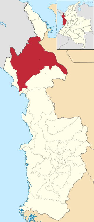
Riosucio is a municipality and town in the Department of Chocó, Colombia. The municipality and town are located in the Atrato River basin, on the Chocoan side of Urabá, a region spanning the departments Chocó and Antioquia.

Afro-Colombians, also known as Black Colombians, are Colombians who have predominantly or total Sub-Saharan African ancestry. They stand out for having dark skin. In the national censuses of Colombia, black people are recognized as 3 official groups: the Raizals, the Palenques and other Afro-Colombians.

Timbiqui is a town and municipality in the Cauca Department, Colombia. It is located on the Pacific Coast of Colombia on the estuary of the Timbiqui River. An earthquake affected its inhabitants on the first of October, 2012.

Because of its natural structure, Colombia can be divided into six distinct natural regions. These consist of the Andean Region, covering the three branches of the Andes mountains found in Colombia; the Caribbean Region, covering the area adjacent to the Caribbean Sea; the Pacific Region adjacent to the Pacific Ocean; the Orinoquía Region, part of the Llanos plains mainly in the Orinoco river basin along the border with Venezuela; the Amazon Region, part of the Amazon rainforest; and finally the Insular Region, comprising the islands in both the Atlantic and Pacific Oceans. Colombia is located in South America.

Luis Gilberto Murillo Urrutia is a Colombian diplomat, mining engineer, and politician who was the Minister of Environment and Sustainable Development from 2016 to 2018. He has also served as Governor of the predominantly Afro-Colombian Department of Chocó in Colombia. Murillo was kidnapped in 2000 and after his release he went into and moved to the United States and only returned to Colombia in 2011. In July 2022, Murillo was nominated by president-elect Gustavo Petro to serve as ambassador to the United States.
William Kennish was an engineer, inventor, explorer, scientist, and poet, known primarily for inventions developed while he served in the British Royal Navy (1821–1841). They ranged from improvements for artillery to navigation and steering devices.
ChocQuibTown is a Colombian hip-hop group that fuses various musical genres. Although the band formed in Cali, the members are originally from the Colombian department of Chocó. The group consists of Carlos "Tostao" Valencia (rapping), Gloria "Goyo" Martínez, and Miguel "Slow" Martínez. The band's music draws influence from a wide variety of modern genres including hip-hop and more recently electronica, combined with traditional Colombian genres including salsa, Latin jazz, and Afro-Latin rhythms.
Personhood is the status of being a person. Defining personhood is a controversial topic in philosophy and law and is closely tied with legal and political concepts of citizenship, equality, and liberty. According to law, only a legal person has rights, protections, privileges, responsibilities, and legal liability.

The Chocó–Darién moist forests (NT0115) is a largely forested, tropical ecoregion of northwestern South America and southern Central America. The ecoregion extends from the eastern Panamanian province of Darién and the indigenous region of Guna Yala to almost the entirety of Colombia's Pacific coast, including the departments of Cauca, Chocó, Nariño and Valle del Cauca.

The Gulf of Tribugá is a gulf on the Pacific coast of Colombia. It contains exuberant mangroves. The bay is a spawning ground for humpback whales. Tourist attractions include diving and watching whales and turtles. There are plans to build a major deep-water port at the village of Tribugá in the main river estuary.

Environmental personhood or juridic personhood is a legal concept which designates certain environmental entities the status of a legal person. This assigns to these entities, the rights, protections, privileges, responsibilities and legal liability of a legal personality. Because environmental entities such as rivers and plants can not represent themselves in court, a "guardian" can act on the entity's behalf to protect it. Environmental personhood emerged from the evolution of legal focus in pursuit of the protection of nature. Over time, focus has evolved from human interests in exploiting nature, to protecting nature for future human generations, to conceptions that allow for nature to be protected as intrinsically valuable. This concept can be used as a vehicle for recognising Indigenous peoples' relationships to natural entities, such as rivers. Environmental personhood, which assigns nature certain rights, concurrently provides a means to individuals or groups such as Indigenous peoples to fulfill their human rights.

Teresa Martínez de Varela was an Afro-Colombian teacher, writer, and social leader. She was one of the first black women in Colombia to publish. Misunderstood, and often denied the ability to publish her works, the intellectual left many unpublished manuscripts at her death. For many years, she was known only as the mother of Jairo Varela, founder of Grupo Niche. Rediscovered in 2009, when Úrsula Mena de Lozano published her biography, some of her works were then collected in an anthology published by the Ministry of Culture in 2010. She is now regarded as one of the pioneering voices to bring African identity in Colombia into the literary landscape of the country and one of the primary intellectuals of her era.

Rights of nature law is the codification and other implementations of the legal and jurisprudential theory of the rights of nature. This legal school of thought describes inherent rights as associated with ecosystems and species, similar to the concept of fundamental human rights.
