
Marsh gas, also known as swamp gas or bog gas, is a mixture primarily of methane and smaller amounts of hydrogen sulfide, carbon dioxide, and trace phosphine that is produced naturally within some geographical marshes, swamps, and bogs.

A swamp is a forested wetland. Swamps are considered to be transition zones because both land and water play a role in creating this environment. Swamps vary in size and are located all around the world. The water of a swamp may be fresh water, brackish water, or seawater. Freshwater swamps form along large rivers or lakes where they are critically dependent upon rainwater and seasonal flooding to maintain natural water level fluctuations. Saltwater swamps are found along tropical and subtropical coastlines. Some swamps have hammocks, or dry-land protrusions, covered by aquatic vegetation, or vegetation that tolerates periodic inundation or soil saturation. The two main types of swamp are "true" or swamp forests and "transitional" or shrub swamps. In the boreal regions of Canada, the word swamp is colloquially used for what is more formally termed a bog, fen, or muskeg. Some of the world's largest swamps are found along major rivers such as the Amazon, the Mississippi, and the Congo.

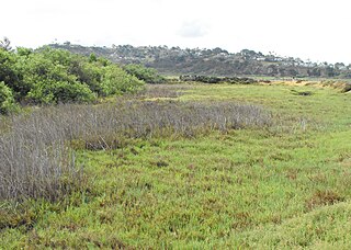
A marsh is - according to ecological definitions - a wetland that is dominated by herbaceous rather than woody plant species. More in general, the word can be used for any low-lying and seasonally waterlogged terrain. In Europe and in agricultural literature low-lying meadows that require draining and embanked polderlands are also referred to as marshes or marshland.

A salt marsh, saltmarsh or salting, also known as a coastal salt marsh or a tidal marsh, is a coastal ecosystem in the upper coastal intertidal zone between land and open saltwater or brackish water that is regularly flooded by the tides. It is dominated by dense stands of salt-tolerant plants such as herbs, grasses, or low shrubs. These plants are terrestrial in origin and are essential to the stability of the salt marsh in trapping and binding sediments. Salt marshes play a large role in the aquatic food web and the delivery of nutrients to coastal waters. They also support terrestrial animals and provide coastal protection.

The Marsh Arabs, also referred to as Ahwaris, the Maʻdān or Shroog —the latter two often considered derogatory in the present day—are Arabian inhabitants of the Mesopotamian marshlands in the modern-day south Iraq, as well as in the Hawizeh Marshes straddling the Iraq-Iran border.

Baillon's crake, also known as the marsh crake, is a small waterbird of the family Rallidae.

The Macquarie Marshes Nature Reserve is a protected natural wetland reserve that is located within the Macquarie Marshes, in the region along the lower Macquarie River in northwestern New South Wales, Australia. The 19,824-hectare (48,990-acre) reserve is situated approximately 600 kilometres (370 mi) northwest of Sydney and 100 kilometres (62 mi) north of Warren.

The marsh deer is the largest deer species from South America.
Abu Al-Khaseeb is a town in Abu Al-Khaseeb District, Basra Governorate, southern Iraq. Its name means "The rich area - agricultural", referring to the fertile Shatt Al-Arab river. It is an agricultural town, well known for its date palm farms on the river. Its population is predominantly Shia Arab. Abu Al-Khaseeb has long been a traditional center for boat-building of the mashoof canoes that are widely used by the Marsh Arabs.
The Xīnmínbǎo Group is a group of geological formations in north central China. They occur across a large depression between the Altai mountains of Mongolia to the north and the Qilian mountains of the Qinghai Plateau to the south, in the Gōngpóquán (公婆泉) and Suànjǐngzi (算井子) basins, and also in the neighbouring Jiuquan Basin.

The Wye Marsh is a wetland area on the south shores of Georgian Bay in Ontario, Canada. The Wye Marsh National Wildlife Area was established on the location in 1978. It is designated a Provincially Significant Wetland by the Ontario Ministry of Natural Resources.

Bandon Marsh National Wildlife Refuge is a U.S. National Wildlife Refuge on Oregon's coast. It is one of six National Wildlife Refuges comprising the Oregon Coast National Wildlife Refuge Complex and is renowned among bird watchers for being able to view rare shorebirds including ruff, Hudsonian godwit, and Mongolian plover. The refuge was last expanded in 1999, it now has 889 acres (3.60 km2) in two units: Bandon Marsh and Ni-les'tun.

Since the 1990s, biogeomorphology has developed as an established research field examining the interrelationship between organisms and geomorphic processes in a variety of environments, both marine, and terrestrial. Coastal biogeomorphology looks at the interaction between marine organisms and coastal geomorphic processes. Biogeomorphology is a subdiscipline of geomorphology.
Brackish marshes develop from salt marshes where a significant freshwater influx dilutes the seawater to brackish levels of salinity. This commonly happens upstream from salt marshes by estuaries of coastal rivers or near the mouths of coastal rivers with heavy freshwater discharges in the conditions of low tidal ranges.

Marshchapel is a coastal village and civil parish in the East Lindsey district of Lincolnshire, England. It is approximately 11 miles (18 km) south-east from Grimsby and 13 miles (21 km) north-east from Louth. It includes the hamlets of West End and Eskham.
Winninowie Conservation Park is a protected area in the Australian state of South Australia located on the east coast of Upper Spencer Gulf about 20 kilometres south by east of Port Augusta and 25 kilometres northwest of Port Germein, in the locality of Miranda. The conservation park was proclaimed in 1990 for the purpose of conserving ‘excellent examples of several coastal and marine ecosystems with sub-tropical affiliations in a temperate environment’ including ‘significant stands of the grey mangrove, Avicennia marina var. resinifera, seagrass and samphire salt marsh communities’. The conservation park's boundaries overlap with those of the Yatala Harbour Upper Spencer Gulf Aquatic Reserve. The conservation park is classified as an IUCN Category Ia protected area.
Cygnet Estuary Conservation Park is a protected area located on the west coast of Nepean Bay on Kangaroo Island in South Australia about 5 kilometres west southwest of Kingscote. It was proclaimed under the National Parks and Wildlife Act 1972 in 2014 on the basis that some existing crown land 'should be protected and preserved for the purpose of conserving any wildlife and the natural features of the land'. The Cygnet Estuary which is considered to be a significant wetland is located within the boundaries of the conservation park.

Marsh Farmhouse is an historic building in Thornton-Cleveleys, Lancashire, England. Built in 1803, it is a Grade II listed building. It is located to the southeast of today's Amounderness Way roundabout at Victoria Road West.