Malabon, officially the City of Malabon (Filipino: Lungsod ng Malabon), is a highly urbanized city in the National Capital Region of the Philippines. According to the 2024 census, it has a population of 389,929 people.[5] Located just north of the city of Manila, Malabon is primarily residential, industrial and one of the most densely populated cities in the metropolis, having a total land area of 15.96 square kilometers (6.16sqmi)
Malabon is part of the sub-region of Metro Manila informally called CAMANAVA, an area which derives its name from the first syllable of its component cities: Caloocan, Malabon, Navotas, and Valenzuela. Caloocan lies to the south and east, Navotas to the west, and Valenzuela to the north. Malabon also borders the town of Obando in the province of Bulacan to the northwest.
Etymology
The name Malabon is from Tagalog word malabon, meaning "having many silt deposits". The name was previously also used for two other places in Cavite during the early Spanish colonial period: Santa Cruz de Malabon (now Tanza) and San Francisco de Malabon (now General Trias).[6] It is previously named as Tambobong, after the rural Tagalog word tambúbong, which translates to "barn".[7]
History
Spanish rule
Malabon church (circa late 1800's - early 1900's)
Originally called Tambobong, Malabon was founded as a visita (hamlet) of Tondo by the Augustinians on May 21, 1599.[citation needed] It remained under the administrative jurisdiction of the Province of Tondo (renamed to Manila in 1859) from 1627 to 1688.
In 1859, three Malabon barangays—San Jose, Navotas, and Bangkulasi—were separated from Tambobong to form a new town that is now Navotas.[8]
The newspaper La Independencia was first printed in Malabon's Asilo de Huérfanos (Orphanage), where children orphaned by the Plague of 1882 were housed.[9][10]
In 1889, a stream tram line from Tondo borough reached Malabon, later to be linked to the other lines of horse drawn and later electric tramcars in Manila, the latter operated by Meralco until the Second World War. The steam connection would be one of the pioneer steam-powered rail services in Southeast Asia and the first at large in the Philippines, pre-dating the Main Line North of the Philippine National Railways which opened in 1892, 3 years later.
Malabon was officially made a municipality of the newly created Province of Rizal on June 11, 1901, by virtue of Philippine Commission Act No. 137.[11] From 1903 to 1906, Navotas was returned to Malabon to form a single municipality.[12][13]
Since independence and cityhood
Malabon remained a municipality of Rizal until November 7, 1975, when Malabon became a part of the National Capital Region or Metro Manila by virtue of Presidential Decree No. 824.[14]
Malabon became a highly urbanized city on April 21, 2001, under Republic Act No. 9019, 407 years after its founding.[15]
Geography
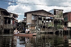
Malabon is one of the most densely populated cities in the Philippines and its low-lying, flat terrain makes it prone to frequent flooding, especially during high tides, heavy rains and when river and dams overflow. The four cities in CAMANAVA are commonly affected by interconnected rivers, one of which is the Tullahan River.
The river system used to be navigable, and fishing was the major livelihood activity in the area. The river used to be wider and deeper with better quality water, and was a regular source of different species of fish, an important food source for local residents. Also, trees and crops like palay (rice) and vegetables used to be grown along the riverbanks. However, these agricultural plots have been replaced by industrial yards, which also became home to thousands of informal settlers who built makeshift dwellings without legal claim to the land.
The permanently flooded area at the Artex Compound in Barangay Panghulo
Floods have worsened in recent years, occurring more frequently and reaching depths of several feet. Most affected are families in the communities that are along or near the riverbanks. The river has become narrower and shallower over the years, and its capacity to hold water has decreased. With more frequent intense rains, the riverbanks flood regularly and flooding reaches farther into low-lying and densely populated areas of the city.[16]
Malabon has an unresolved boundary dispute with Caloocan, wherein both cities claim Caloocan's Barangays 160 and 161, Libis Baesa, (notably the site of North Luzon Expressway's Balintawak Toll Plaza) as within their jurisdiction. In 2025, the Supreme Court of the Philippines dismissed Caloocan’s petition questioning the constitutionality of Republic Act No. 9019 (Malabon City Charter), citing it as premature. The Court instead directed both cities to resolve the issue through procedures under the Local Government Code, starting with their respective city councils.[21] Prior to this, in 2014, both city governments signed a memorandum of understanding (MOU) to develop 80 hectares (200 acres) of disputed land located within Caloocan's Libis Baesa area and Malabon's Barangay Potrero. The MOU preempted any court decisions on the dispute that began in 2001, when Malabon, upon its conversion to a highly urbanized city, took control over lands formerly under Caloocan's jurisdiction.[22]
Malabon belongs to the Roman Catholic Diocese of Kalookan. Almost 80% of the people here adhere to this religion. Today there are eight Roman Catholic Parishes in Malabon.
Malabon bears the old images of San Bartolome in the Poblacion and the La Inmaculada Concepcion, canonically crowned since 1986 during the pontificate of Pope John Paul II.
Malabon industries include sugar refinery, patis- (fish sauce) making, cigar-making, candle production, fishing and ilang-ilang flower-extract production (the distilled perfume is exported).
On April 21, 2008, Malabon's newly constructed 11-story city hall building along F. Sevilla Boulevard in Barangay San Agustin, was inaugurated by Gloria Macapagal Arroyo on Malabon's 7th City anniversary. It was dubbed as a "potential business center of the city," a one-stop shop for government transactions, due to its state-of-the-art facilities such as 3 high-speed elevators and the new city hall building and its offices' "digital system."[36]
The Malabon City Tourism Office launched the Malabon Tricycle Tours in December 2014. The tours take visitors to eight heritage sites including the newly renovated 400-year-old San Bartolome Church as well as to notable heritage houses like the Raymundo House and Ibaviosa House.[37]
On March 14, 2015, the tours started to offer visitors a unique gastronomic experience through visits to the city's home-based eateries. This culinary aspect was the brainchild of current Mayor Antolin Oreta III's wife Melissa Oreta, the next mayor of Malabon.[38]
The Malabon Zoo and Aquarium, located in Potrero, is a small zoo that features an array of caged animals, along with an aquarium and gardens.
Malabon is considered as the local Venice, due to year-long floods and gradual sinking. It is a place famous for its Pancit Malabon and its predominantly Atlantic ambience. It is also famous for other variety of foods (kakanin), such as puto sulot, puto bumbong, sapin-sapin, broas, bibingka and camachile. The culinary delights are abundant in its specialty eateries.
Malabon houses several old homes of historical value: the Dionisio family home, the Rivera house, the Villongco house, the Luna house, the Pascual house, the Chikiamco house, the Rojas-Borja house, the (Teodoro) Luna house, the Santos-Lapus house, the Pantaleon Bautista house, the Syjuco (formerly Gaza) house, and the Raymundo house, considered to be the oldest located along C. Arellano Street. Other old but well-preserved heritage houses in Malabon include the Asilo de Huérfanos, the Paez House, and the Nepomuceno House.[42]
There are various modes of transportation that people use to go in and out of the city and to the barangays.
Jeepney Routes
Malabon (Hulo) via Acacia Monumento (LRT/Wise) – it traverses the entire length of Gov. Pascual Ave. from Potero to Concepcion, and Gen. Luna St. from Concepcion to Hulong-Duhat. From Monumento, prominent loading/unloading stations are Tuazon, Del Monte, University Ave., Marcelo, Plastikan, Goldendale, Palengke (Acacia-Tinajeros), Robinsons Town Mall Malabon/Francis, Catmon, Gulayan, Niugan, BNR (Muzon), Santo Rosario Village, Arellano University, Concepcion, Ilang-ilang to Javier (Baritan), Celia (Bayan-bayanan), Hulong-Duhat Plaza Terminal. From Hulo, the jeepney takes M. Naval St., right to A. Bonifacio St., left to C. Arellano St. (one way southbound), left to Kalahi St. (before Burgos), left to Gen. Luna St. (one way northbound), and then right back to Gov. Pascual Avenue until it gets to either LRT Victory Mall terminal or Wise terminal in Monumento.
Malabon (Bayan) via Letre Monumento – it traverses Samson Road in Caloocan, C-4 Road (Longos), P. Aquino Ave. and Rizal Avenue. From Monumento, as it passes the city of Caloocan, loading/unloading stations within Malabon are: Paradise, Letre/MC, Tonsuya, Magsaysay St. and Bayan terminal. To go back, jeeps turn right to Gen. Luna St., left to Sacristia St. (Behind St. James Academy), left to F. Sevilla Blvd. around Malabon City Hall back to Rizal Avenue until it gets to Monumento.
Malabon (Hulo) via Bayan Navotas – it traverses C. Arellano St. (Malabon), M. Naval St. (Navotas) and Gov. Pascual St. (Navotas). From Hulo, prominent destinations within Malabon are: Badeo Cuatro, Concepcion, Burgos, Camus, Bayan/Palengke then it enters the streets of Navotas traversing M. Naval St. northbound and Gov. Pascual St. southbound.
Gasak (Hulo) via Agora Ilaya/Divisoria – it traverses C. Arellano St., Leoño St. (Tañong), C-4 Road (Tañong), NBBN Road (Navotas), NBBS Road, Honorio Lopez Blvd. (Manila), Juan Luna St. and Nicolas Zamora St.
Gasak (Hulo) Recto – from Hulo, it traverses C. Arellano St., Rizal Avenue, P. Aquino Ave., Letre Road, Dagat-dagatan Avenue then it enters the city of Caloocan until it gets to Recto, Manila.
Sangandaan via Tatawid Polo – it traverses M.H. del Pilar St. from Sangandaan (Caloocan) to Polo (Valenzuela). This route does not begin nor end in Malabon but it serves the people of Malabon from barangay Tugatog, Tinajeros, Maysilo and Tatawid (Santulan).
Monumento via Tatawid Polo – it traverses Gov. Pascual Ave., then turn right to M.H. del Pilar St. until it gets to Polo (Valenzuela) and back.
Ferry terminals which uses boats include the Badeo Cuatro, connecting Flores to San Roque, Navotas; and Badeo Tres, connecting Concepcion to Daanghari, Navotas.
Education
Malabon National High School, the pilot secondary school of the cityCity of Malabon University
Tertiary level
The De La Salle Araneta University is the seventh campus of De La Salle Philippines. It was formerly known as the Gregorio Araneta University Foundation which was established in 1946 as the Araneta Institute of Agriculture in Bulacan, then transferred to Malabon the year after. In 1978, it was renamed as the Gregorio Araneta University Foundation. Integration of the university to the DLS System started since 1987 and in 2002 became an official member of the system. The university specializes in Veterinary Medicine and Agricultural Sciences.
As an agricultural University – Salikneta Farm (formerly known as Saliksik-Araneta) located at the City of San Jose Del Monte, Bulacan. Its total land area is 64 hectares of farmland originally owned by Gregorio Araneta University Foundation. The wide farmland is used for forestry and agricultural operations for student training purposes. Aside from serving as a laboratory and research facility, an agricultural-forestry-ecology-tourism-integrated farm complete with recreational facilities such as horse back riding, carabao cart-pulling for passengers, fishing, camping, mini-zoo and conference area is envisioned in Salikneta.
Arellano University–Jose Rizal Campus and Elisa Esguerra Campus, established in 1950, is the fifth campus of Arellano University.
The City of Malabon University (CMU) is the city university. It is located in Longos, Malabon.
There are also TESDA-accredited schools in the city. It includes the City of Malabon Polytechnic Institute, St. Michael Arcangel Technological Institute, College of Saint Amatiel, and St. Catherine Institute of Technology
Secondary schools
Malabon National High School or MNHS is the pilot secondary school and the most populous school in the city. The school offers three curriculum: Engineering and Science Education Program (ESEP; popularly known as Special Science Class or SSC), Special Program in the Arts (SPA) and the K-to-12 Education Curriulum.
There are other thirteen public secondary schools in Malabon namely the Malabon National High School and Malabon City National Science and Mathematics High School, Concepcion Technical Vocational School, Tinajeros National High School, Acacia National High School, Santiago Syjuco Memorial Integrated Secondary School, Malabon City TechVoc and Entrepreneurship Senior High School, Ninoy Aquino Senior High School, Panghulo National High School, Potrero National High School, Longos National High School, Tañong National High School, Tugatog National High School, and Imelda Integrated Secondary School.
There are also a number of private schools in Malabon area such as St. James Academy, Immaculate Conception Academy of Malabon (Formerly Immaculate Conception Parochial School), St. Therese of the Child Jesus Academy, Higher Ground Baptist Academy Foundation Inc, Philippine Malabon Cultural Institute, Seibo College, and PROBEX School.
Integrated schools
There are other five public integrated schools in Malabon area such as Dampalit Integrated School, Catmon Integrated School, Col. Ramon Camus Integrated School, Tañong Integrated School, and Tonsuya Integrated School.
There are also a number of private schools in Malabon area such as The POTTER & The Clay Christian School, Philippine Buddhist Seng Guan Memorial Institute, and St. Michael Learning Center Inc.
Elementary schools
There are twenty other public elementary schools in Malabon area such as Malabon Elementary School, Dampalit Elementary School I, Maysilo Elementary School, Panghulo Elementary School Main and I, Santolan Elementary School, Concepcion Elementary School, Santiago Syjuco Memorial School, Dela Paz Elementary School, Amang Rodriguez Elementary School, Tañong Elementary School 1, Longos Elementary School, Ninoy Aquino Elementary School, Epifanio delos Santos Elementary School, Acacia Elementary School, Tinajeros Elementary School, Guillermo Sevilla Sanchez Memorial Elementary School, and Potrero Elementary School Main and I.
There are also a number of private schools in Malabon area such as Abakadang Kayumanggi Learning Center, Academia De La Lilia, Bright Beginnings Center for Young Children, CEC Berean Christian Academy Inc., Cedar Oaks Christian School Inc., Christian Academy of Malabon, La Cabecera de Montessori, Inc., La Felicidad Learning Center Inc., Labagala's Child Development Center, Learning Journey Child Growth Center, Inc., MFCBC Christian Academy, Inc., Power Minds Learning Center, Sacred Heart School, St. Narciseus Academy Inc., Salazar's School of Learning, Sampedro Children's Learning Center, SME Child Development Center, Inc., T.A.L.K. Learning Center, United Methodist Parish School of Malabon Inc., and White Angel Academy Inc.
This page is based on this Wikipedia article Text is available under the CC BY-SA 4.0 license; additional terms may apply. Images, videos and audio are available under their respective licenses.