Ayala Avenue's segment from the present-day Gil Puyat (Buendia) Avenue to Makati Avenue used to be the primary runway of the Nielson Airport, which was inaugurated in 1937 and was one of the first airports built in Luzon, while its extension occupies a segment of an old road that connected the Santa Ana Park and McKinley–Pasay Road.[3][4][5] The airport was destroyed during the Japanese occupation of the Philippines on December 10, 1941, and resumed operations after the end of World War II in 1947. The airport closed in 1948, and its permanent facilities were passed on to the owner of the land, Ayala y Compañía. The runways were then converted into roads as part of Ayala's plan to build a new business district in the area.[6] The modern avenue was completed in the mid-1950s,[7] eventually connecting it to Highway 54 (now EDSA).[8]
In 1978, Ayala Avenue was involved in the feasibility study conducted by the Japan International Cooperation Agency for the proposed the Circumferential Road 3 (C-3) of Manila's arterial road network. The construction of a flyover along Ayala Avenue, crossing Buendia Avenue and Malugay Street, was also proposed but was never realized. However, the widening of the avenue's segment north of Malugay and the addition of a new segment between Kamagong Street and Metropolitan Avenue, linking it to South Avenue, were materialized.[9] The extension north of Buendia once became part of C-3.[10][11] In 1998, a flyover was built for left turners onto EDSA northbound.[12]
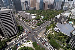
The middle lane of Ayala Avenue is designated as a public transport lane, while the outermost lane is designated as a bicycle lane.
In 2020, in response to the growing popularity of bicycle commuting and ownership amidst the COVID-19 pandemic, the Makati Central Estate Association (MaCEA) and Ayala Land, through its Make it Makati campaign, designated 3-meter-wide (9.8ft) bicycle lanes along Ayala Avenue from Gil Puyat Avenue to EDSA, protected by bollards and exclusive to non-motorized bicycles and scooters. Bicycle boxes were also added to intersections to allow left turns. The lanes underwent a trial run on August 7, 2020, and were completed on September 7, 2020. Following this, designated stops for public transport services were also moved to the middle lane of the road.[13]
Shared lanes scheme controversy
On February 10, 2023, MaCEA and Ayala Land announced plans to replace the Ayala Avenue bicycle lanes with sharrows effective February 15.[14][15] Despite the backlash from cycling groups, authorities proceeded with the changes.[16][17][18] On February 12, cycling groups opposed to the scheme organized a protest bike ride along Ayala Avenue. In response, authorities deferred the implementation of the sharrows scheme to March 6 to gather feedback and engage in dialogue with the cycling community.[15][17][19][20]
The Ayala Triangle is a sub-district of the Makati Central Business District, comprising the parcel of land between Ayala Avenue, Makati Avenue and Paseo de Roxas and the buildings on those streets. Ayala Corporation, its subsidiaries and affiliates, in addition to many multinational companies, banks and other major businesses, are located within the triangle. A few upscale boutiques, restaurants and a park called Ayala Triangle Gardens are also located in the area.
PBCom Tower, one of the tallest buildings in the Philippines, is located at Ayala Avenue and V.A. Rufino Street. It serves as the headquarters of the Philippine Bank of Communications. It was the tallest building in the Philippines from 2000 to 2017.
Apartment Ridge
Apartment Ridge is a complex of apartment and condominium buildings along Makati and Ayala Avenues outside Urdaneta Village. The Peninsula Manila, Makati Tuscany, Discovery Primea, The Estate Makati, Ritz Towers, Pacific Plaza Condominium, Twin Towers, and Urdaneta Apartments are located in this area.
Government-owned buildings
Makati City Police Station
Makati City Fire Station
Both have relocated to Gil Puyat Avenue, also in Barangay San Antonio, in 2024.[21] However, these old facilities along Ayala Avenue remain intact as of January 2025.
Since September 2023, sections of Ayala Avenue from Salcedo Street and H.V. Dela Costa Street to West Street and Fonda Street, along with portions of Paseo de Roxas and Makati Avenue within the vicinity of the Ayala Triangle Gardens, are closed to traffic every Sunday from 6:00 am to 10:00 am PHT. Branded as Car-Free Sundays, the car-free day initiative was launched by Ayala Land and the Makati City Government to promote cycling, jogging, and other recreational activities in a safer and more pedestrian-friendly environment.[22][23]
Ayala Avenue has been a significant venue for demonstrations in the Philippines. Following the assassination of Ninoy Aquino in 1983, it became a focal point for protests against President Ferdinand Marcos, with office workers showing support by throwing yellow confetti torn from Yellow Pages of the PLDT directories, the color which had become associated with Aquino, from buildings above.[26]
From August 2000 to January 2001, Ayala Avenue became the focal point for protests once again, this time against President Joseph Estrada, who later resigned upon being deposed during the Second EDSA Revolution.[8] Protests continued to Estrada's successor, Gloria Macapagal Arroyo, with notable gatherings on July 13, 2005, demanding her resignation of Arroyo amid allegations of electoral fraud that led to her re-election in 2004,[27] and in February 2008 against her administration.[28]
On September 8, 2023, climate activists held a protest in front of the Ninoy Aquino Monument at the intersection of Ayala Avenue and Paseo de Roxas to urge, notably, G20 world leaders to shift from fossil fuels to renewable energy.[29] On June 26, 2024, members of the Asian Peoples' Movement on Debt and Development held a protest calling for a halt to debt-related policies.[30] The August Twenty-One Movement (ATOM), which was founded by Agapito Aquino in response to his brother Ninoy's assassination, also holds their Run/Ride On Against Revision (ROAR) initiative on the avenue every third (or fourth) Sunday of the month, coinciding with the Car-Free Sundays.[31][32]
On May 7, 2022, Ayala Avenue became the site of Vice President Leni Robredo's final campaign rally (miting de avance) for her 2022 presidential campaign, attended by approximately 780,000 people.[33][34]
1 2 O'Gorman Anderson, Benedict Richard (2003). Southeast Asia Over Three Generations: Essays Presented to Benedict R. O'G. Anderson. SEAP Publications. pp.291–294. ISBN0877277354.
This page is based on this Wikipedia article Text is available under the CC BY-SA 4.0 license; additional terms may apply. Images, videos and audio are available under their respective licenses.