Julia Vargas Avenue

Last updated • 3 min readFrom Wikipedia, The Free Encyclopedia

Julia Vargas Avenue
Doña Julia Vargas Avenue
Julia Vargas ADB Intersection.jpg
Intersection of Julia Vargas Avenue, ADB Avenue, and San Miguel Avenue
NamesakeDoña Julia Vargas de Ortigas
Length2.3 km (1.4 mi)
West endAH26 (N1) sign.svg AH 26 (N1) (Epifanio de los Santos Avenue) in Mandaluyong
Major
junctions
ADB Avenue / San Miguel Avenue
Meralco Avenue
East endN11 (Philippines).svg N11 (Eulogio Rodriguez Jr. Avenue) in Pasig

Julia Vargas Avenue is a central east–west arterial road that passes through Ortigas Center in Metro Manila, Philippines. It is a four-lane divided road with one-way protected bike lanes that run parallel to Ortigas Avenue to the north and Shaw Boulevard to the south. The avenue stretches 2.3 kilometers (1.4 mi) from Eulogio Rodriguez Jr. Avenue (C-5 Road) in Ugong, Pasig in the east to Epifanio de los Santos Avenue (EDSA) in Wack-Wack Greenhills, Mandaluyong in the west.

Contents

It was named for philanthropist Doña Julia Vargas de Ortigas, wife of Ortigas & Company Limited Partnership founder Don Francisco Ortigas y Barcinas, who owned the Hacienda de Mandaloyon estate on which Ortigas Center was built. [1] [2]

Route description

Afternoon traffic along Julia Vargas Avenue Julia Vargas Avenue Rush Hour 1 (cropped).jpg
Afternoon traffic along Julia Vargas Avenue
The Julia Vargas Elevated Plaza above the intersection of Julia Vargas and F. Ortigas Road Julia Vargas Elevated Plaza Exterior.jpg
The Julia Vargas Elevated Plaza above the intersection of Julia Vargas and F. Ortigas Road
People walking along the Ortigas Walkways above Julia Vargas Avenue Julia Vargas Elevated Walkway 1.jpg
People walking along the Ortigas Walkways above Julia Vargas Avenue
The intersection of Julia Vargas Avenue and F. Ortigas Jr. Road (Emerald Avenue) in 2013, before the construction of the elevated plaza Vargas and Emerald.jpg
The intersection of Julia Vargas Avenue and F. Ortigas Jr. Road (Emerald Avenue) in 2013, before the construction of the elevated plaza

Julia Vargas Avenue originates at an intersection with C-5 Road, also known as E. Rodriguez, Jr. Avenue, where SM Center Pasig is located. It heads west across Valle Verde. Between the next intersection at Lanuza Avenue and City Golf, Vargas is the boundary between Valle Verde 3 and 4 villages. It passes the Ortigas Home Depot, a Sitel call center building, and a row of bars on the northern side before it comes to an intersection with Meralco Avenue and the Meralco flyover.

West of Meralco Avenue, the avenue officially enters the Ortigas Center business district. It passes the office towers in San Antonio, Pasig, toward the border with Barangay Wack-Wack Greenhills, Mandaluyong, at the intersection with ADB Avenue and San Miguel Avenue, where the El Pueblo Real de Manila strip mall is located. This span of Julia Vargas Avenue onwards used to contain one-way unprotected bike lanes, which have since faded.

The Ortigas Walkways Project, a series of elevated pedestrian walkways, covers the span of Julia Vargas Avenue within San Antonio. [3]

From ADB and San Miguel to Bank and St. Francis, Vargas is one-way westbound only. The left side of the road only allows left turns to St. Francis Street, while the right side continues as a service road and allows right turns to Bank Drive. At the western edge of Ortigas Center are St. Francis Square Mall, San Miguel Corporation Headquarters, and SM Megamall. The avenue ends at EDSA as a two-way carriageway.

Development

Carpool lanes

The road was previously a six-lane divided avenue with no bike lanes until 2018 when an experimental road diet was implemented. This diet changed the corridor into a widened four-lane (two lanes per direction) divided avenue with one-way bike lanes with bollards. In each direction, one lane acted as a carpool lane for at least four passengers per vehicle, while the other was designated as a non-carpool lane. [4]

This traffic scheme has since been rescinded due to motorist confusion. Despite this, the lane markings remain, and vehicle traffic during rush hours largely ignores them, informally reverting the avenue to its six-lane (three lanes per direction) state.

Motorcycle and bike lanes

In March 2021, Pasig Mayor Vico Sotto announced that the avenue would undergo another road diet, shrinking the two car lanes and adding a motorcycle lane parallel to the bike lane. The bike lane will also be physically separated by plant boxes. [5]

Intersections

ProvinceCity/Municipalitykm [6] miDestinationsNotes
Pasig CityN11 (Philippines).svg N11 (E. Rodriguez Jr. Avenue)Traffic light intersection.
Frontera Drive / Kaimito StreetFrontera Drive is part of Ortigas East (formerly Tiendesitas).
Kaimito Street provides access for Valle Verde 2.
Valle Verde 5 Celery gate [a 1] Westbound access only. Access for Valle Verde 5.
Valle Verde 2 Sampaguita gate [a 2] Access for Valle Verde 2.
Lanuza Avenue
Coconut StreetAccess for Valle Verde 4.
Molave StreetAccess for Valle Verde 3.
Meralco Avenue Traffic light intersection. Meralco Avenue goes over the road via flyover.
Sapphire RoadEastern terminus of the Ortigas Walkways Project.
Grant Road
Emerald AvenueTraffic light intersection. Elevated plaza segment of Ortigas Walkways Project.
Ruby Road
PasigMandaluyong boundaryADB Avenue / San Miguel AvenueTraffic light intersection. Road becomes one-way towards EDSA. Western terminus of the Ortigas Walkways Project.
Mandaluyong Bank Drive / St. Francis StreetRoad becomes two-way again and acts as a service road for SM Megamall.
AH26 (N1) sign.svg AH 26 (N1) Western terminus.
1.000 mi = 1.609 km; 1.000 km = 0.621 mi

Landmarks

IBP Building IBP Building.jpg
IBP Building

Notes

  1. Name is conjectural.
  2. Name is conjectural.

Related Research Articles

<span class="mw-page-title-main">Mandaluyong</span> Highly urbanized city in Metro Manila, Philippines

Mandaluyong, officially the City of Mandaluyong, is a highly urbanized city in the National Capital Region of the Philippines. According to the 2020 census, it has a population of 425,758 people.

<span class="mw-page-title-main">Ortigas Center</span> Central Business District in Metro Manila, Philippines.

Ortigas Center is a central business district located within the joint boundaries of Pasig, Mandaluyong and Quezon City, within the Metro Manila region in the Philippines. With an area of more than 100 hectares, it is Metro Manila's second most important business district after Makati Central Business District. It is governed by Ortigas Center Association, Inc.

<span class="mw-page-title-main">EDSA</span> Limited-access circumferential highway around Metro Manila

Epifanio de los Santos Avenue, commonly referred to by its acronym EDSA, is a limited-access circumferential highway around Manila, the capital city of the Philippines. It passes through 6 of Metro Manila's 17 local government units or cities, namely, from north to south, Caloocan, Quezon City, San Juan, Mandaluyong, Makati, and Pasay.

<span class="mw-page-title-main">SM Megamall</span> Shopping mall in Mandaluyong, Philippines

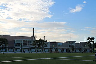
SM Megamall, is a shopping mall located in Ortigas Center, Mandaluyong, Metro Manila, Philippines. It is the third largest shopping mall in the Philippines and the thirteenth largest in the world. SM Megamall is developed and operated by SM Prime Holdings. The mall occupies a land area of approximately 10 hectares and has a total floor area of 474,000 square meters (5,100,000 sq ft). The mall has a maximum capacity of 4 million people.

<span class="mw-page-title-main">Shaw Boulevard station</span> Train station in Mandaluyong, Philippines

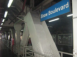
Shaw Boulevard station is an elevated Metro Rail Transit (MRT) station located on the MRT Line 3 (MRT-3) system in the Mandaluyong portion of Ortigas Center. The station is named after Shaw Boulevard, since the station lies directly above the boulevard. Being at the center of the whole line, many commuters regard Shaw Boulevard station as the "central terminal" of the line.

<span class="mw-page-title-main">Ortigas station</span> Train station in Mandaluyong, Philippines

Ortigas station is an elevated Metro Rail Transit (MRT) station located on the MRT Line 3 (MRT-3) system in the Mandaluyong portion of Ortigas Center. The station is named after either Ortigas Center or Ortigas Avenue, which is nearby.

<span class="mw-page-title-main">Shangri-La Plaza</span> Shopping mall in Mandaluyong, Philippines

Shangri-La Plaza is a shopping mall located in Ortigas Center, Mandaluyong, Philippines. It is owned and operated by the Kuok Group of Companies, the owner of the worldwide chain of Shangri-La Hotels and Resorts. Shangri-La Plaza opened on November 21, 1991 and contains more than 300 shops and restaurants.

<span class="mw-page-title-main">One San Miguel Avenue</span> Office skyscraper in Pasig, Philippines

The One San Miguel Avenue is an office skyscraper located at San Miguel Avenue in Ortigas Center, Pasig, Philippines. It was completed in 2001 and stands at 183 metres from ground up to the architectural top, although if measured with its antennas, it stands at 203 metres. It has 54 floors aboveground and 7 basement levels.

<span class="mw-page-title-main">Greenhills, San Juan</span> Barangay in San Juan, Metro Manila, Philippines

Greenhills is an urban barangay in San Juan, Metro Manila, Philippines. It is the largest barangay in San Juan, covering a total area of 2.09 square kilometers (209 ha) and spanning over a third of San Juan's total land area.

<span class="mw-page-title-main">Ortigas Avenue</span> Major Metro Manila-Rizal arterial

Ortigas Avenue is a 12.1 km (7.5 mi) highway connecting eastern Metro Manila and western Rizal in the Philippines. It is one of the busiest highways in Metro Manila, serving as the main thoroughfare of the metro's east–west corridor, catering mainly to traffic to and from Rizal.

<span class="mw-page-title-main">Shaw Boulevard</span> 4–8 lane highway in the Philippines

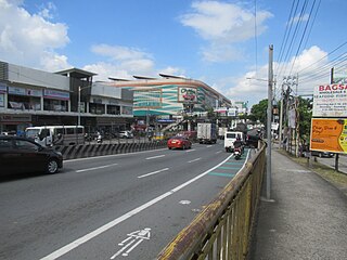
Shaw Boulevard is a 4-8 lane highway connecting the cities of Mandaluyong and Pasig in the Philippines. The boulevard is named after William James Shaw, founder of the Wack Wack Golf and Country Club in Mandaluyong. The road is one of the major thoroughfares of the Ortigas Center in Mandaluyong and Pasig, housing many shopping malls like the Starmall shopping center and the posh Shangri-La Plaza at the EDSA-Shaw intersection and The Marketplace, which is visible from the Kalentong-Shaw intersection and Sevilla Bridge.

<span class="mw-page-title-main">Pioneer Street</span>

Pioneer Street is the continuation of Boni Avenue east of Epifanio de los Santos Avenue (EDSA) in eastern Metro Manila, Philippines. The street has four lanes for most of its course, beginning at the EDSA junction in Barangka Ilaya, Mandaluyong, where traffic emerges from the Boni Avenue tunnel, up to its easternmost point at the Shaw Boulevard junction at the boundary of barangays Kapitolyo and San Antonio in Pasig, adjacent to Ortigas Center. En route, it passes through the Robinsons Cybergate Complex, where Forum Robinsons is located, the United Laboratories plant, and Greenfield District, a mixed-use development south of Ortigas Center by the junction with Shaw Boulevard. Pioneer Street is also the location of several new condominium developments, call center sites and a few strip malls. It is served by Boni Station of the MRT-3 at EDSA.

<span class="mw-page-title-main">Meralco Avenue</span> Road in Pasig, Metro Manila, Philippines

Meralco Avenue is a north-south thoroughfare in Ortigas Center in Pasig, Metro Manila, Philippines. It links Ortigas Avenue in the north and Shaw Boulevard in the south and borders the western edge of Valle Verde in Ugong. It is named after the Manila Electric Company (Meralco), headquartered at the avenue's intersection with Ortigas Avenue. Other notable businesses on Meralco Avenue include UnionBank Plaza, Marco Polo Ortigas Manila, Ayala Malls The 30th, Metrowalk, and the mixed-use development called Capitol Commons at the former Rizal Provincial Capitol lot on Meralco and Shaw Boulevard.

<span class="mw-page-title-main">Ortigas Interchange</span> Road junction

The Ortigas Interchange, also known as the EDSA–Ortigas Interchange or the Ortigas Flyover, is a three-level partial stack interchange at the boundary between Mandaluyong and Quezon City in Metro Manila, Philippines which serves as the junction between Epifanio de los Santos Avenue (EDSA) and Ortigas Avenue. Originally a regular four-way intersection, the current interchange was built in 1991 as the flagship infrastructure project of President Corazon Aquino.

<span class="mw-page-title-main">Capitol Commons</span> Mixed-use development in Pasig, Philippines

Capitol Commons is a mixed-use development in Oranbo, Pasig, Metro Manila, Philippines. It is a redevelopment of the former Rizal Provincial Capitol complex located in the village of Oranbo adjacent to the Ortigas Center financial district. The 10-hectare (25-acre) site being developed by Ortigas & Company Limited Partnership, the same developer behind Ortigas Center, features Pasig's first high-end shopping center called Estancia at Capitol Commons. Once completed, the P25-billion mixed-use commercial, residential and office development will have 35,000 square meters (380,000 sq ft) of retail space, 20,000 square metres (220,000 sq ft) of office space for knowledge process outsourcing (KPO) companies, and 280,000 square meters (3,000,000 sq ft) of residential units. The development is also home to the Capitol Commons Park, which takes up fifty percent of the development.

<span class="mw-page-title-main">Radial Road 5</span> Road network in Luzon, Philippines

Radial Road 5, informally known as the R-5 Road, is a network of roads and bridges which comprise the fifth arterial road of Metro Manila in the Philippines. The road links the city of Manila with Mandaluyong and Pasig in the east, leading out of Metro Manila into the province of Rizal and south towards Laguna. It is the only arterial road traversing the east side of Laguna de Bay.

<span class="mw-page-title-main">Index of Metro Manila–related articles</span>

The following is an alphabetical list of articles related to the Philippine capital region of Metro Manila.

<span class="mw-page-title-main">Santa Monica–Lawton Bridge</span> Bridge in Metro Manila, Philippines

The Santa Monica–Lawton Bridge, also known as the Kalayaan Bridge and Bonifacio Global City–Ortigas Link Bridge, is a four-lane, two-way bridge across the Pasig River that connects Lawton Avenue in the Embo barangays of Cembo and West Rembo in Taguig to Fairlane Street in barangays Kapitolyo and Pineda in Pasig. The bridge spans 613.77 meters (2,013.7 ft), and its construction cost is ₱1.857 billion as of 2017. The bridge also includes a 565-meter (1,854 ft) viaduct that connects it to 8th Avenue in Bonifacio Global City, Taguig.

<span class="mw-page-title-main">Greenfield District</span> Place

Greenfield District is a transit-oriented mixed-use development in Mandaluyong, Metro Manila, Philippines. It is a redevelopment of the old United Laboratories (Unilab) pharmaceutical plant and adjacent retail market in Barangay Highway Hills adjoining Barangay Kapitolyo in Pasig to the east. The 15-hectare (37-acre) mixed commercial and residential complex is in the crossroads of EDSA and Shaw Boulevard immediately south of the Ortigas Center financial district. It consists of an office tower, condominium high-rises, a central park, retail centers and recreational facilities.

References

  1. About OCLP published by Ortigas & Company Limited Partnership; accessed October 15, 2013.
  2. Tableau: encyclopedia of distinguished personalities in the Philippines Archived October 15, 2013, at the Wayback Machine published by Ortigas Foundation Library; accessed October 15, 2013.
  3. Medina, Rachelle (August 16, 2019). "Ortigas Center Has Become a Walkable District, and We Didn't Even Notice It". SPOT.PH. Retrieved August 31, 2021.
  4. "'Apat Dapat': Parts of Julia Vargas Ave. in Pasig declared as carpool lanes". GMA News Online. Retrieved August 31, 2021.
  5. "J. Vargas Ave. in Pasig to have a dedicated motorcycle, bike lane - Auto News". AutoIndustriya.com. March 19, 2021. Retrieved August 31, 2021.
  6. "Road and Bridge Inventory". www.dpwh.gov.ph. Retrieved July 31, 2020.

14°35′3″N121°4′3″E / 14.58417°N 121.06750°E / 14.58417; 121.06750