Sampaloc is a district of Manila, Philippines. It is referred to as the University Belt or simply called "U-Belt" for numerous colleges and universities are found within the district such as the University of Santo Tomas, the oldest extant university in Asia; the National University, the first private nonsectarian and coeducational institution in the Philippines; the Far Eastern University, known for its Art Deco campus and cultural heritage site of the Philippines; and the University of the East, once dubbed as the largest university in Asia in terms of enrollment. The district is bordered by the districts of Quiapo and San Miguel in the south, Santa Mesa district in the south and east, Santa Cruz district in the west and north, and Quezon City in the northeast.

Epifanio de los Santos Avenue, commonly referred to by its acronym EDSA, is a limited-access circumferential highway around Manila, the capital city of the Philippines. It passes through 6 of Metro Manila's 17 local government units or cities, namely, from north to south, Caloocan, Quezon City, San Juan, Mandaluyong, Makati, and Pasay.

Santa Mesa is a district in Manila, Philippines. It is surrounded by the Pasig River on the southwestern side, and by the San Juan River on its southern and eastern side. Land borders include the districts of San Miguel to the west and Sampaloc to the north; and to the northeast is Quezon City.

The Metropolitan Manila Development Authority is a government agency of the Philippines responsible for constituting the regional government of Metro Manila, comprising the capital city of Manila, the cities of Quezon City, Caloocan, Pasay, Mandaluyong, Makati, Pasig, Marikina, Muntinlupa, Las Piñas, Parañaque, Valenzuela, Malabon, Taguig, Navotas and San Juan, and the municipality of Pateros.

Legarda station is an elevated Light Rail Transit (LRT) station located on the LRT Line 2 (LRT-2) system in Sampaloc, Manila. It is named after Legarda Street, where the station sits above it. The street in turn is named after Benito Legarda, a Filipino legislator.
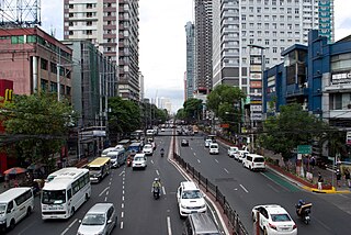
España Boulevard is an eight–lane major thoroughfare in Manila, the capital of the Philippines. It is named after Spain, the country that formerly held the Philippines as a colony for more than 300 years. True to its name, several Spanish names abound on the street. It starts at the Welcome Rotonda near the boundary of Quezon City and Manila and ends with a Y-intersection with Lerma and Nicanor Reyes Streets in Manila.

Radial Road 6 (R-6), informally known as the R-6 Road, is a network of roads and bridges which comprise the sixth arterial road of Metro Manila in the Philippines. It passes through the cities of Manila, Quezon City, San Juan, Pasig, and Marikina, as well as Cainta and Antipolo in the province of Rizal, up to Santa Maria, Laguna and Infanta, Quezon.

Radial Road 7 (R-7), informally known as the R-7 Road, is a network of roads and bridges which comprise the seventh arterial road of Metro Manila in the Philippines. It connects the cities of Manila and Quezon City. It is one of ten radial roads in Metro Manila that connect Manila outwards to adjacent cities.

Circumferential Road 2 (C-2), informally known as the C-2 Road, is a network of roads and bridges which comprise the second beltway of Metro Manila in the Philippines. Spanning some 10.18 kilometers (6.33 mi), it connects the districts of Tondo, Santa Cruz, Sampaloc, San Miguel, Santa Mesa, Paco, Pandacan, and Malate in Manila.
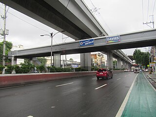
Ramon Magsaysay Boulevard, also known simply as Magsaysay Boulevard and formerly as Santa Mesa Boulevard, is the principal artery of Santa Mesa in Manila, Philippines. It is a six-lane divided roadway that travels east–west from Gregorio Araneta Avenue near the city's border with Quezon City and San Juan to Lacson Avenue and the Nagtahan Interchange, close to the district of San Miguel. The entire length of the boulevard serves as the district boundary between Sampaloc in the north and Santa Mesa in the south, with the LRTA's Line 2 running along its median. East of Gregorio Araneta, the road continues as Aurora Boulevard, while west of Lacson, it extends as Legarda Street via Legarda Flyover into San Miguel and Quiapo.
Remedios Circle, also known as the Plaza de la Virgen de los Remedios, Remedios Rotonda, and Rotary Circle, is a traffic circle in Malate, Manila, Philippines, serving as the intersection between Remedios Street, Jorge Bocobo Street and Adriatico Street. The circle and a traversing street are both named after Nuestra Señora de los Remedios, the patroness of the nearby Malate Church, and is one of two major open spaces in Malate, the other being Plaza Rajah Sulayman.

Lacson Avenue is the principal northwest–southeast artery in the Sampaloc district in northern Manila, Philippines. It is a 6-8 lane median divided avenue that runs approximately 2.9 kilometers (1.8 mi) from Tayuman Street in Santa Cruz to Nagtahan Interchange. It is a component of Circumferential Road 2 of the Manila arterial road network and N140 of the Philippine highway network.

Jose Laurel Street is a tree-lined street in the district of San Miguel in north-central Manila, Philippines. It runs parallel to the Pasig River from the Nagtahan Interchange south-westwards to Ayala Bridge. It is where Malacañang Palace and several other government buildings are located.

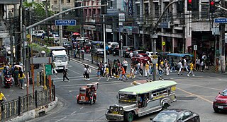
Legarda Street is a short street in the Sampaloc district of Manila, Philippines. It crosses through the eastern section of the University Belt area in a generally east–west orientation between the Nagtahan Interchange and the intersection with Nepomuceno Street in Quiapo. Legarda station of the LRTA's Line 2 system serves it.

Carriedo Fountain is a fountain in Santa Cruz, Manila, Philippines. It was built in honour of the 18th-century Capitán General of Manila, Don Francisco Carriedo y Peredo, benefactor of Manila's pipe water system. It was moved three times before its current location at Plaza Santa Cruz in front of the Santa Cruz Church.

The following is an alphabetical list of articles related to the Philippine capital region of Metro Manila.

The Sales Interchange, also known as the Nichols Interchange, is a hybrid interchange at the boundary of Pasay and Taguig in Metro Manila, Philippines. It is composed of a lower partial cloverleaf interchange serving as the junction between the South Luzon Expressway, Sales Road, Lawton Avenue, West Service Road and East Service Road and an upper Directional T serving as the junction between the Skyway and the NAIA Expressway.
National Route 180 (N180) is a secondary national route that forms part of the Philippine highway network. It runs from Cubao, Quezon City to Ermita, Manila.
The Nagtahan Link Bridge is a series of road bridges crossing the Pasig River between the districts of Paco and Santa Mesa in Manila, Philippines. Constructed from 1996 to 1998, the road links and bridges pass along Paco-Santa Mesa Road, also referred to as Tomas Claudio Street.

NLEX Connector, also known as the NLEX–SLEX Connector Road, NLEX Connector Road, and NLEX Segment 11 during the planning stages, is a 7.7-kilometer (4.8 mi), four-lane elevated expressway in Metro Manila, Philippines. It connects the NLEX Harbor Link to the Metro Manila Skyway, which connects further to the North and South Luzon Expressways. The highway traverses parallel to the PNR Metro Commuter Line. It has five interchanges, four of which are currently operational. Alongside NLEX Harbor Link, trucks are allowed to use it.

