Gregorio Araneta Avenue

Last updated

Gregorio Araneta Avenue
N130 (Philippines).svg
C-3
Gregorio Araneta Avenue sign.svg
G. Araneta Avenue in July 2023.jpg
Gregorio Araneta Avenue in July 2023
Namesake Gregorio S. Araneta
Maintained by Department of Public Works and Highways
Length5.3 km (3.3 mi)
Component
highways
Location Quezon City and San Juan
North endSanto Domingo Avenue in Quezon City
Major
junctions
South endN. Domingo Street in San Juan
Construction
Completion1985 [1]
Gregorio Araneta Avenue near the Calamba Street intersection, before the construction of the Skyway Stage 3. Gregorio Araneta Avenue.jpg
Gregorio Araneta Avenue near the Calamba Street intersection, before the construction of the Skyway Stage 3.

Gregorio Araneta Avenue is a suburban arterial road in the Santa Mesa Heights area of Quezon City, northeastern Metro Manila, Philippines. Built in 1985, [1] it is a 6- to 8-lane divided avenue designated as part of Circumferential Road 3 (C-3) and a physical continuation of Sergeant Rivera Street which travels from Santo Domingo Avenue at its north end near Balintawak in Quezon City, and meets N. Domingo Street in the south in San Juan near the border with Santa Mesa, Manila. En route, it intersects with Del Monte Avenue, Quezon Avenue, Eulogio Rodriguez Sr. Avenue and Magsaysay-Aurora Boulevard passing through barangays Balingasa, Manresa, Masambong, Sienna, Santo Domingo, Talayan, Tatalon, Santol, and Doña Imelda in Quezon City and Progreso in San Juan.

Contents

The avenue lies in a flood-prone zone in close proximity to the San Francisco del Monte and San Juan Rivers. It was named after lawyer and landowner Gregorio S. Araneta, who owned the Santa Mesa Heights Subdivision on which the avenue was built. [2]

Between Del Monte Avenue and Quezon Avenue, Gregorio Araneta Avenue runs alongside the Talayan Creek, serving as the waterway median of the avenue. As a result of the Skyway Stage 3 project, parts of the waterway median were converted into a closed culvert for access to and from the Skyway.

The Metro Manila Skyway Stage 3 traverses almost the entire length of the road, starting from Sergeant Rivera Avenue down to the San Juan River.

Funeral row

Gregorio Araneta Avenue is best known as the location of some of the biggest funeral parlors in the metropolis. These are the Arlington Memorial Chapels, La Funeraria Paz, Ascension Columbary, Cosmopolitan, Nacional Memorial Homes, and the Sanctuarium (formerly Capitol Memorial). The oldest is Funeraria Nacional which moved to Gregorio Araneta from its old address in downtown Avenida Rizal in 1968, and now affiliated with Heritage Park after an extensive renovation. It was followed by La Funeraria Paz in the 1970s and Arlington, which converted the old Thomas Jefferson Library on the avenue into a funeral facility, in 1985. [3]

Automated Trash Rake

In 2014, the Department of Science and Technology built an automated garbage rake in the intersection of Araneta Avenue and Mauban Street, functioning as a cleaning facility for the river, in response to the perennial flooding and garbage problems in the area. Garbage trucks regularly collected garbages that were captured from the river, as well as those dumped nearby. [4] It is currently under repairs and refurbishment.

Intersections

ProvinceCity/MunicipalitykmmiDestinationsNotes
Quezon City 95.6Sto. Domingo AvenueNorthern terminus. Continues west as N130 (Philippines).svg N130 (Sergeant Rivera Avenue)
Balingasa Creek
Quezon City Valentin Ventura StreetNorthbound only
Mauban Street
Wayan StreetNorthbound access for pedestrians only. Fenced off entry.
G. Roxas StreetSouthbound only
Northern terminus of Talayan Creek median section
8.55.3Del Monte AvenueTraffic light intersection. Access to Siena College, San Francisco del Monte district, and A. Bonifacio Avenue.
85.0Norberto S. Amoranto Sr. (Retiro) AvenueTraffic light intersection. Access to La Loma district and the districts of Sampaloc and Santa Cruz in Manila.
Calamba StreetOpposite segments accessible through nearby roads.
Skyway Northbound entrance under construction. [5]
Skyway Skyway-Quezon Avenue Exit. Southbound entrance. [6]
Maria Clara StreetTraffic light intersection. Newly installed since June 2023. Access to La Loma district and the districts of Sampaloc and Santa Cruz in Manila.
Southern terminus of Talayan Creek median section
Skyway Skyway-Quezon Avenue Exit. Northbound exit. [6]
P. Florentino StreetOpposite segments accessible through nearby roads.
74.3N170 (Philippines).svg N170 (Quezon Avenue)Traffic light intersection. Quezon Avenue-Araneta Avenue Underpass.
Agno Street ExtensionOpposite segments accessible through nearby roads.
ROTC Hunters StreetNorthbound only
Skyway Skyway-Quezon Avenue Exit. Southbound exit and northbound entrance. [6]
Kaliraya RoadUnsignaled intersection
Victory AvenueUnsignaled intersection
Kitanlad StreetSouthbound only
74.3E. Rodriguez Sr. AvenueTraffic light intersection, No left turns and no U-turns; U-Turn slot located ahead.
Kapiligan StreetNorthbound only
Skyway Skyway-G. Araneta (formerly E. Rodriguez) off-ramp. Southbound entrance. [7]
Tomas Arguelles StreetSouthbound only
Bayani StreetTraffic light intersection
Baloy StreetUnsignaled intersection
95.6Landargun StreetUnsignaled intersection
Tamar StreetSouthbound only. Fenced-off entry.
Skyway Skyway-G. Araneta on-ramp. Northbound exit. [8]
Palanza StreetTraffic light intersection
63.7N180 (Philippines).svg N180 (Magsaysay Boulevard/Aurora Boulevard)Southern terminus of N130; change to unnumbered route. [9]
Quezon CitySan Juan boundarySan Juan-Santa Mesa Bridge over San Juan River
San Juan 63.7 Skyway Skyway-Aurora Boulevard on-ramp. Future northbound exit [10]
N. Domingo StreetSouthern terminus. Access to Santa Mesa in Manila, New Manila and Cubao in Quezon City, and Kalentong in Mandaluyong.
1.000 mi = 1.609 km; 1.000 km = 0.621 mi

Related Research Articles

<span class="mw-page-title-main">Quezon City</span> Highly urbanized city in Metro Manila, Philippines

Quezon City, also known as the City of Quezon and Q.C., is the most populous city in the Philippines. According to the 2020 census, it has a population of 2,960,048 people. It was founded on October 12, 1939, and was named after Manuel L. Quezon, the second president of the Philippines.

<span class="mw-page-title-main">San Juan, Metro Manila</span> Highly urbanized city in Metro Manila, Philippines

San Juan, officially the City of San Juan, is a 1st class highly urbanized city in the National Capital Region of the Philippines. According to the 2020 census, it has a population of 126,347 people. It is geographically located at Metro Manila's approximate center and is also the country's smallest city in terms of land area.

<span class="mw-page-title-main">Santa Mesa</span> District of Manila, Metro Manila, Philippines

Santa Mesa is a district in Manila, Philippines. It is surrounded by the Pasig River on the southwestern side, and by the San Juan River on its southern and eastern side. Land borders include the districts of San Miguel to the west and Sampaloc to the north; and to the northeast is Quezon City.

<span class="mw-page-title-main">V. Mapa station</span> LRT Line 2 station in Manila

V. Mapa station is an elevated Light Rail Transit (LRT) station located on the LRT Line 2 (LRT-2) system in Sampaloc, Manila. It is one of the four stations in the line with a reserve track nearby together with Santolan, Anonas and Araneta Center–Cubao. The station during its inception was formerly called as G. Araneta station but was renamed into the current name due to the minor realignment of some stations that has caused the change of proximity to the V. Mapa Street. The station serves the areas of Santa Mesa, Manila, Quezon City, and San Juan. The station is situated at Ramon Magsaysay Boulevard, near its intersection with Victorino Mapa Street in Santa Mesa, Manila.

<span class="mw-page-title-main">Metro Manila Skyway</span> Elevated expressway in Metro Manila, Philippines

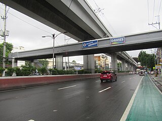
The Metro Manila Skyway, officially the Metro Manila Skyway System (MMSS) or simply the Skyway, is an elevated highway serving as the main expressway of Metro Manila, Philippines. It connects the North and South Luzon Expressways with access to Ninoy Aquino International Airport via the NAIA Expressway (NAIAX). It is the first fully grade-separated highway in the Philippines and one of the longest elevated highways in the world, with a total length of approximately 39.2 kilometers (24.4 mi).

<span class="mw-page-title-main">Quirino Highway</span> Road in the Philippines

The Quirino Highway, formerly called the El Quirino Express Road or Ipo Road, is a four-to-eight lane, secondary highway that connects Quezon City to the municipality of Norzagaray in Bulacan, Philippines. The road is designated as National Route 127 (N127) of the Philippine highway network within the city bounds of Quezon City, Radial Road 7 (R-7), and a spur of Radial Road 8 (R-8) of Metro Manila's arterial road network.

<span class="mw-page-title-main">Radial Road 6</span>

Radial Road 6 is the sixth radial road in Metro Manila, the Philippines. It passes through the cities of Manila, Quezon City, San Juan, Pasig, and Marikina, as well as Cainta, and Antipolo in the province of Rizal up to Santa Maria, Laguna and Infanta, Quezon

<span class="mw-page-title-main">Circumferential Road 3</span> Third beltway of Metro Manilas highways

Circumferential Road 3 (C-3), informally known as the C-3 Road, is a network of roads and bridges that all together form the third beltway of Metro Manila in the Philippines. Spanning some 10.8 kilometers (6.7 mi), it connects the cities of Caloocan, Navotas, Quezon City, and San Juan.

<span class="mw-page-title-main">Gilmore Avenue (Quezon City)</span>

Gilmore Avenue, formerly known as Gilmore Street, is a two-lane, one-way road in Quezon City, Metro Manila, the Philippines. It runs one-way from Eulogio Rodriguez Sr. Avenue in New Manila and terminates at Nicanor Domingo Street in Valencia, continuing on as the two-way Granada Street until it reaches the city border with San Juan, where it becomes Ortigas Avenue.

<span class="mw-page-title-main">San Juan River (Metro Manila)</span> Major tributary of the Pasig River

The San Juan River is one of the main river systems in Metro Manila, Philippines, and is a major tributary of the Pasig River. It begins near La Mesa Dam as the San Francisco del Monte River, which officially takes the name San Juan River when it meets with Mariblo Creek in Quezon City. As the San Juan River, it passes through Quezon City, San Juan, the Manila district of Santa Mesa and Santa Ana, and Mandaluyong.

<span class="mw-page-title-main">Quezon Avenue</span> Major road in Quezon City, Philippines

Manuel L. Quezon Avenue, more often called as Quezon Avenue, or simply Quezon Ave, is a 6.1-kilometer (3.8 mi) major thoroughfare in Metro Manila named after President Manuel Luis Quezon, the second president of the Philippines. The avenue starts at the Quezon Memorial Circle and runs through to the Welcome Rotonda near the boundary of Quezon City and Manila.

<span class="mw-page-title-main">Aurora Boulevard</span> Road in the Philippines

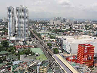
Aurora Boulevard is a four-to-ten lane major thoroughfare in Quezon City and San Juan in Metro Manila, Philippines. It was named after Doña Aurora Quezon, the consort of Commonwealth President Manuel Luis Quezon. It is one of the major roads in the commercial district of Araneta City in Cubao. Line 2 follows the alignment of the boulevard.

<span class="mw-page-title-main">Quirino Avenue</span> Major street in Manila, Philippines

President Elpidio Quirino Avenue, more commonly known as Quirino Avenue, is a 6-10 lane divided highway in Manila, Philippines. It runs for 3.6 kilometers (2.2 mi) in a northeast–southwest direction from Nagtahan Bridge across from Santa Mesa in the north to Roxas Boulevard in Malate in the south. It passes through Paco and Pandacan districts where it also serves as a truck route between Port Area and South Luzon Expressway. North of Nagtahan Bridge, the road continues as Nagtahan Street. It is designated as part of Circumferential Road 2. It is named after Elpidio Quirino, the sixth President of the Philippines.

<span class="mw-page-title-main">Magsaysay Boulevard</span>

Ramon Magsaysay Boulevard, also known simply as Magsaysay Boulevard and formerly as Santa Mesa Boulevard, is the principal artery of Santa Mesa in Manila, Philippines. It is a six-lane divided roadway that travels east–west from Gregorio Araneta Avenue near the city's border with Quezon City and San Juan to Lacson Avenue and the Nagtahan Interchange, close to the district of San Miguel. The entire length of the boulevard serves as the district boundary between Sampaloc in the north and Santa Mesa in the south with the LRTA's Line 2 running along its median. East of Gregorio Araneta, the road continues as Aurora Boulevard while west of Lacson, it extends as Legarda Street via Legarda Flyover into San Miguel and Quiapo.

<span class="mw-page-title-main">San Juan River Bridge</span> Bridge in Metro Manila, Philippines

The San Juan River Bridge, also known as Pinaglabanan Bridge, San Juan del Monte Bridge, San Juan Bridge and the Old Santa Mesa Bridge, is a bridge that connects San Juan and Manila, spanning the San Juan River. The 46.85-meter (153.7 ft) bridge connects the N. Domingo Street in San Juan and Old Santa Mesa Street in Manila. The location of the bridge served as a battlefield during the 1896 Philippine Revolution against the Spaniards and the 1899 Philippine–American War.

<span class="mw-page-title-main">Index of Metro Manila–related articles</span>

The following is an alphabetical list of articles related to the Philippine capital region of Metro Manila.

<span class="mw-page-title-main">Santa Cruz, Quezon City</span> Barangay in Quezon City, Metro Manila, Philippines

Santa Cruz often abbreviated as Sta. Cruz is a barangay located in the San Francisco Del Monte district of Quezon City with an approximate land area of 44 hectares bounded by South and West Triangles in the East, Quezon Avenue and Barangay Paligsahan in the South, Nayong Kanluran in the Northeast and Barangay Paltok in the North.

<span class="mw-page-title-main">Sucat–Paco–Araneta–Balintawak Transmission Line</span> 230 kV overhead power line in the Philippines

The Sucat–Paco–Araneta–Balintawak Transmission Line also known as Muntinlupa–Manila–Doña Imelda–Quezon Transmission Line, and formerly known as Sucat–Araneta–Balintawak Transmission Line from July 2000 to October 2012, is a 230,000 volt, single-circuit, three-part transmission line in Metro Manila, Philippines that connects Sucat and Balintawak substations of National Grid Corporation of the Philippines (NGCP), with line segment termination at NGCP Araneta substation in Quezon City and Manila Electric Company (Meralco) Paco substation in Paco, Manila.

National Route 180 (N180) is a secondary national route that forms part of the Philippine highway network, running from Cubao, Quezon City to Ermita, Manila.

References

  1. 1 2 "Road and Bridge Inventory". Department of Public Works and Highways . Retrieved June 1, 2023.
  2. History and Important Events of Sta. Teresita Parish published by the National Shrine of Our Lady of Lourdes in Quezon City. Retrieved December 19, 2013.
  3. QC's Araneta Avenue: Showcase strip for the Filipino 'burol' published by the Philippine Daily Inquirer. Retrieved December 19, 2013.
  4. "Home".
  5. "Coming soon: two less Skyway bottlenecks". Philippine Daily Inquirer. December 28, 2022. Retrieved February 20, 2024.
  6. 1 2 3 Grecia, Leandre (December 29, 2020). "Here are all the entry and exit points of the partially opened Skyway Stage 3". TopGear Philippines.
  7. "San Miguel opens 2 new ramps of Skyway 3". ABS-CBN News. February 11, 2021.
  8. De Guzman, Marcus (September 29, 2021). "SMC to open three new Skyway 3 on-ramps this Friday". AutoIndustriya.com. Retrieved October 2, 2021.
  9. "NCR". Department of Public Works and Highways . Retrieved May 25, 2020.
  10. Pornelos, Vince (September 5, 2019). "Here's your first look at the Quezon City segment of Skyway Stage 3". Autoindustriya.com. Retrieved May 17, 2020.

14°36′54″N121°1′0″E / 14.61500°N 121.01667°E / 14.61500; 121.01667