Balingasa

Last updated
Balingasa
Balintawak
Cloverleaf
Barangay
Balintawak, A. Bonifacio Avenue, Skyway Stage 3 (Quezon City; 03-21-2021).jpg
Ph quezon city balingasa.png
Map of Quezon City showing Balingasa
Balingasa
Coordinates: 14°39′2″N121°0′5″E / 14.65056°N 121.00139°E / 14.65056; 121.00139
Country Philippines
Region National Capital Region
City Quezon City
District 1st District of Quezon City
Government
  Type Barangay
  Barangay CaptainMa. Teresa Montalbo [1]
Area
[2]
  Total0.8111 km2 (0.3132 sq mi)
Population
 (2020) [3]
  Total19,260
  Density24,000/km2 (62,000/sq mi)
Time zone UTC+8 (PST)
Postal Code
1105
Area code 2
PSGC 137404013
Website Facebook

Balingasa, commonly known as Balintawak and Cloverleaf, is an administrative division in eastern Metro Manila, the Philippines. It is an urban barangay located in Quezon City, at the city's western boundary with Caloocan.

Contents

The barangay's borders are defined by EDSA and barangay Unang Sigaw to the north, barangays Pag-Ibig Sa Nayon and Damar to the south, barangay Manresa and Gregorio Araneta Avenue in the southeast, and barangay Apolonio Samson in the east. [2]

Etymology

Following the Second World War, the inhabitants of the area rebuilt their houses and man-made artesian wells, locally known in Tagalog as a balon , were dug as a primary source of water. After one such well was dug, crystal-clear spring water came out of the other wells. This well had its base made out of small pieces of stones, known as gasang, and was referred to by the settlers as the balun ng gasang (gasang well). The balun ng gasang became a common byword of households in the area and was often mispronounced as balungasa, until it was later commonly pronounced as balingasa. [2]

History

During the Spanish colonial era, the area was a densely forested area. Upon the arrival of settlers, through the native kaingin method of slash-and-burn cultivation, the once-forested area was cultivated into fields and farms where different cereals and vegetables were planted. The area was established as a barrio of Caloocan in 1882, with Catalino Magsalin as its first teniente del barrio, also known as the cabeza de barangay. [2]

After the formation of the new Philippine capital of Quezon City, the barrio was incorporated into the new city in 1939 pursuant to Commonwealth Act No. 502, transferring Balingasa and other nearby Caloocan sitios and barrios to Quezon City. [4] [2]

The barrio was recognized as a barangay in 1975 by Quezon City Mayor Norberto S. Amoranto. [2]

Notable landmarks

A monument to the Cry of Balintawak or Cry of Pugad Lawin, which marked the start of the Philippine Revolution in 1896, was erected in the area, which was transferred to another location.

The Balintawak Interchange, a road network shaped like a cloverleaf, connects the North Luzon Expressway and the Epifanio delos Santos Avenue (EDSA) under the jurisdiction of both Barangays Balingasa and Unang Sigaw.

Also, Skyway Stage 3 runs through the barangay above A. Bonifacio Avenue, connecting South Luzon Expressway (SLEx) and North Luzon Expressway (NLEx) while avoiding the traffic-torn street of Metro Manila.

North Edsa corridor

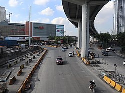
Other notable landmarks (mostly along EDSA) include the Balintawak Market, [5] the LRT Balintawak station and transport hubs to and from Downtown Manila, Northern Quezon City, CaMaNava and Bulacan areas.

The Cloverleaf, an Ayala Land estate and the former site of Central Textile Mills purchased in 2013, is predominantly within the area of Balingasa while the rest is under the jurisdiction of Barangay Apolonio Samson. Once fully developed, the township will include Alveo and Avida Land residential condominiums, a Qualimed hospital facility, commercial buildings for Business Process Outsourcing (BPO) locators and Ayala Malls Cloverleaf (opened on October 25, 2017).

Another condominium project, The Celandine project of DMCI Properties, is located just south of The Cloverleaf along A. Bonifacio Avenue.

The entrance to the Manila Electric Company (Meralco) and National Grid Corporation of the Philippines (NGCP) Balintawak substation, which hosts various distribution and transmission lines operated and maintained by Meralco and NGCP such as the Sucat–Paco–Araneta–Balintawak and Hermosa–Duhat–Balintawak transmission lines, is also located along EDSA.

Demography

As of the 2020 census of the National Statistics Office (Philippines), the population of Balingasa is 19,260. [3]

Facilities

The barangay maintains a Quezon City public library, [6] while the government-run Balingasa High School is under the Schools Division Office (SDO) of Quezon City.

See also

Related Research Articles

<span class="mw-page-title-main">EDSA</span> Limited-access circumferential highway around Metro Manila

Epifanio de los Santos Avenue, commonly referred to by its acronym EDSA, is a limited-access circumferential highway around Manila, the capital city of the Philippines. It passes through 6 of Metro Manila's 17 local government units or cities, namely, from north to south, Caloocan, Quezon City, San Juan, Mandaluyong, Makati, and Pasay.

<span class="mw-page-title-main">Caloocan</span> Highly urbanized city in Metro Manila, Philippines

Caloocan, officially the City of Caloocan, is a 1st class highly urbanized city in Metro Manila, Philippines. According to the 2020 census, it has a population of 1,661,584 people making it the fourth-most populous city in the Philippines.

<span class="mw-page-title-main">North Luzon Expressway</span> Major controlled-access highway in the Philippines

The North Luzon Expressway (NLEX), signed as E1 of the Philippine expressway network, partially as N160 of the Philippine highway network, and R-8 of the Metro Manila arterial road network, is a controlled-access highway that connects Metro Manila to the provinces of the Central Luzon region in the Philippines. The expressway, which includes the main segment and its various spurs, has a total length of 101.8 kilometers (63.3 mi) and travels from its northern terminus at Santa Ines Interchange to its southern terminus in Balintawak Interchange, which is adjacent to its connection to Skyway, an elevated toll road that connects the NLEX to its counterpart in the south, the South Luzon Expressway. The segment of the expressway between Santa Rita Exit in Guiguinto and the Balintawak Interchange in Quezon City is part of Asian Highway 26 of the Asian highway network. Despite that the name stating the word "North Luzon", the expressway only ends at Santa Ines Exit at Mabalacat, Pampanga which is located in Central Luzon.

<span class="mw-page-title-main">Pan-Philippine Highway</span> Highway in the Philippines traversing most of the country

The Pan-Philippine Highway, also known as the Maharlika Highway, is a network of roads, expressways, bridges, and ferry services that connect the islands of Luzon, Samar, Leyte, and Mindanao in the Philippines, serving as the country's principal transport backbone. Measuring 3,379.73 kilometers (2,100.07 mi) long excluding sea routes not counted by highway milestones, it is the longest road in the Philippines that forms the country's north–south backbone component of National Route 1 (N1) of the Philippine highway network. The entire highway is designated as Asian Highway 26 (AH26) of the Asian Highway Network.

<span class="mw-page-title-main">Balintawak station</span> Train station in Quezon City, Philippines

Balintawak station is an elevated Light Rail Transit (LRT) station located on the LRT Line 1 (LRT-1) system at the boundary of barangays Balingasa, Unang Sigaw, and Apolonio Samson in Quezon City. It opened on March 22, 2010 as part of the LRT-1 North Extension Project. The station serves passengers going to and from the northern parts of Luzon using the North Luzon Expressway.

Balintawak may refer to:

<span class="mw-page-title-main">Cry of Pugad Lawin</span> First act in the Philippine Revolution

The Cry of Pugad Lawin was the beginning of the Philippine Revolution against the Spanish Empire.

<span class="mw-page-title-main">Quirino Highway</span> Road in the Philippines

The Quirino Highway, formerly called the El Quirino Express Road or Ipo Road, is a four-to-eight lane, secondary highway that connects Quezon City to the municipality of Norzagaray in Bulacan, Philippines. The road is designated as National Route 127 (N127) of the Philippine highway network within the city bounds of Quezon City, Radial Road 7 (R-7), and a spur of Radial Road 8 (R-8) of Metro Manila's arterial road network.

<span class="mw-page-title-main">Radial Road 8</span>

Radial Road 8, more commonly referred to as R-8, is a network of roads and bridges that altogether form the eighth radial road of Manila in the Philippines. It runs north-south through northern Metro Manila linking the City of Manila with Quezon City, Caloocan, and Valenzuela into the northern provinces of Bulacan, Pampanga, Tarlac, Pangasinan, and La Union. The portion of R-8 between Guiguinto and Balintawak is also designated a component of the Pan-Philippine Highway network (AH26). It also has a spur segment in Quirino Highway from NLEX to its junction with R-7 at Commonwealth Avenue, both in Quezon City.

<span class="mw-page-title-main">Circumferential Road 3</span> Third beltway of Metro Manilas highways

Circumferential Road 3 (C-3), informally known as the C-3 Road, is a network of roads and bridges that all together form the third beltway of Metro Manila in the Philippines. Spanning some 14.93 kilometers (9.28 mi), it connects the cities of Caloocan, Makati, Navotas, Pasay, Quezon City, and San Juan.

<span class="mw-page-title-main">Battle of Pasong Tamo</span> 1896 conflict in the Philippine Revolution

The Battle of Pasong Tamo was a series of short skirmishes shortly after the Cry of Balintawak between the remaining Katipuneros in Caloocan and the Guardia Civil.

<span class="mw-page-title-main">Samson Road</span>

Samson Road is a major east–west street in Caloocan, northern Metro Manila, Philippines. The road is a continuation of Epifanio de los Santos Avenue (EDSA), linked to it via the Bonifacio Monument Roundabout (Monumento) to form a single through route. These roads form part of Circumferential Road 4 (C-4) of the Metro Manila's arterial road network, National Route 120 of the Philippine highway network, and Asian Highway 26 of the Asian highway network.

<span class="mw-page-title-main">Outline of Metro Manila</span> Overview of and topical guide to Metro Manila

The following outline is provided as an overview of and topical guide to Metro Manila:

<span class="mw-page-title-main">Index of Metro Manila–related articles</span>

The following is an alphabetical list of articles related to the Philippine capital region of Metro Manila.

<span class="mw-page-title-main">Andres Bonifacio Avenue</span> Major road in Metro Manila, Philippines

Andres Bonifacio Avenue, also known as A. Bonifacio Avenue, is a 3.784-kilometer (2.351 mi) national secondary road connecting the North Luzon Expressway and Epifanio de los Santos Avenue at Balintawak Interchange in Quezon City and Blumentritt Road at the city's boundary with Manila in a north–south direction.

<span class="mw-page-title-main">Balintawak Interchange</span> Cloverleaf interchange in Quezon City, Philippines

The Balintawak Interchange, also known as the Balintawak Cloverleaf, is a two-level cloverleaf interchange in Quezon City, Metro Manila, the Philippines which serves as the junction between Epifanio de los Santos Avenue (EDSA) and the North Luzon Expressway (NLEx). Opened in 1968 as part of the initial 37-kilometer (23 mi) NLEx segment between Quezon City and Guiguinto, Bulacan, it was one of the first projects of the Construction and Development Corporation of the Philippines, now the Philippine National Construction Corporation (PNCC).

<span class="mw-page-title-main">Bonifacio Monument</span> Monument in Caloocan, Philippines

The Andrés Bonifacio Monument, commonly known simply as Bonifacio Monument or Monumento, is a memorial monument in Caloocan, Philippines which was designed by National Artist Guillermo Tolentino to commemorate the Philippine revolutionary Andrés Bonifacio, the founder and Supremo of the Katipunan, who fought for independence from the politically and socially ruthless colonial rule by Spain.

<span class="mw-page-title-main">Sucat–Paco–Araneta–Balintawak Transmission Line</span> 230 kV overhead power line in the Philippines

The Sucat–Paco–Araneta–Balintawak Transmission Line also known as Muntinlupa–Manila–Doña Imelda–Quezon Transmission Line, and formerly known as Sucat–Araneta–Balintawak Transmission Line from July 2000 to October 2012, is a 230,000 volt, single-circuit, three-part transmission line in Metro Manila, Philippines that connects Sucat and Balintawak substations of National Grid Corporation of the Philippines (NGCP), with line segment termination at NGCP Araneta substation in Quezon City and Manila Electric Company (Meralco) Paco substation in Paco, Manila.

<span class="mw-page-title-main">Ayala Malls Cloverleaf</span> Shopping mall in Metro Manila, Philippines

Ayala Malls Cloverleaf is a shopping mall developed and managed by Ayala Malls, inside the Cloverleaf Estate in Quezon City.

References

  1. "Quezon City Barangay Officials". Quezon City Government. 2021-01-08. Retrieved 2022-05-22.
  2. 1 2 3 4 5 6 History of QC Barangays: Journey to Early Beginnings of Quezon City Barangays. Vol. 1. Quezon City: Quezon City Public Library. 2019.
  3. 1 2 Census of Population (2020). Table B - Population and Annual Growth Rates by Province, City, and Municipality - By Region. Philippine Statistics Authority . Retrieved 8 July 2021.
  4. "History". City Government of Caloocan. Retrieved March 12, 2024.
  5. Lozada, Bong (12 April 2020). "QC stops retail selling in Balintawak, wholesale and product drop-off allowed". Inquirer.net. Retrieved 11 November 2020.
  6. "Quezon City public library branches". Quezon City Government Official Website. Retrieved 11 November 2020.