
Mandaluyong, officially the City of Mandaluyong, is a highly urbanized city in the National Capital Region of the Philippines. According to the 2020 census, it has a population of 425,758 people.

Ortigas Center is a central business district located within the joint boundaries of Pasig, Mandaluyong and Quezon City, within the Metro Manila region in the Philippines. With an area of more than 100 hectares, it is Metro Manila's second most important business district after Makati Central Business District. It is governed by Ortigas Center Association, Inc.

Bonifacio Global City is a central business district and major financial hub located in Taguig, Metro Manila, Philippines. It is located 11 kilometers (6.8 mi) southeast of the capital city of Manila. The district experienced commercial growth following the sale of a 440 ha military base at Fort Bonifacio by the Bases Conversion and Development Authority (BCDA). The entire district used to be the part of the main Philippine Army camp.

Greenhills is an urban barangay in San Juan, Metro Manila, Philippines. It is the largest barangay in San Juan, covering a total area of 2.09 square kilometers (209 ha) and spanning over a third of San Juan's total land area.

Ortigas Avenue is a 12.1 km (7.5 mi) highway running from eastern Metro Manila to western Rizal in the Philippines. It is one of the busiest highways in Metro Manila, serving as the main thoroughfare of the metro's east–west corridor, catering mainly to the traffic to and from Rizal.

Julia Vargas Avenue is a central east–west arterial road that passes through Ortigas Center in Metro Manila, Philippines. It is a four-lane divided road with one-way protected bike lanes that runs parallel to Ortigas Avenue to the north and Shaw Boulevard to the south. The avenue stretches 2.3 kilometers (1.4 mi) from Eulogio Rodriguez Jr. Avenue in Ugong, Pasig in the east to Epifanio de los Santos Avenue (EDSA) in Wack-Wack Greenhills, Mandaluyong in the west.

Boni Avenue is a major east–west thoroughfare in Mandaluyong, eastern Metro Manila, Philippines. It is a six-lane divided avenue that runs from Aglipay Street to Epifanio de los Santos Avenue (EDSA). After crossing EDSA via the EDSA-Boni tunnel, the road continues as Pioneer Street towards Pasig. The avenue is named after the nickname of Bonifacio Javier, a decorated guerrilla leader during World War II and former mayor of Mandaluyong.

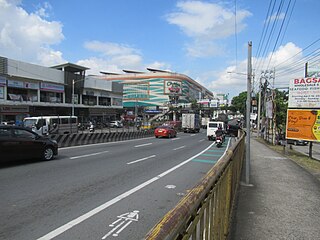
Pioneer Street is the continuation of Boni Avenue east of Epifanio de los Santos Avenue (EDSA) in eastern Metro Manila, Philippines. The street has four lanes for most of its course beginning at the EDSA junction in Barangka Ilaya, Mandaluyong, where traffic emerges from the Boni Avenue tunnel, up to its easternmost point at the Shaw Boulevard junction at the boundary of barangays Kapitolyo and San Antonio in Pasig, adjacent to Ortigas Center. En route, it passes through the Robinsons Cybergate Complex where Forum Robinsons mall is located; the United Laboratories plant; and Greenfield District, a mixed-use development south of Ortigas Center by the junction with Shaw Boulevard. Pioneer Street is also the location of several new condominium developments, call center sites and a few strip malls. It is served by Boni Station of the MRT-3 at EDSA.

Meralco Avenue is a north-south thoroughfare located in Ortigas Center in Pasig, Metro Manila, Philippines. It links Ortigas Avenue in the north and Shaw Boulevard in the south and borders the western edge of Valle Verde in Ugong. It is named for the Manila Electric Company, also known as Meralco, which is headquartered on the avenue's junction with Ortigas Avenue. Other notable businesses on Meralco Avenue include UnionBank Plaza, Marco Polo Ortigas Manila, Ayala Malls The 30th, Metrowalk, and the mixed-use development called Capitol Commons at the former Rizal Provincial Capitol lot on Meralco and Shaw Boulevard.
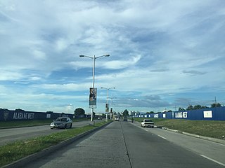
Daang Hari, also known as the Las Piñas–Muntinlupa–Laguna–Cavite Link Road, is a collector road that links southern Metro Manila to the province of Cavite in the Philippines. It begins as a north–south road from Commerce Avenue, just south of the Alabang–Zapote Road running for 5.9 kilometers (3.7 mi) on the boundary of Las Piñas and Muntinlupa. It then runs east–west for about 9.2 kilometers (5.7 mi) from its junction with Daang Reyna, winding through the cities of Bacoor, Imus, Dasmariñas, and General Trias.

Capitol Commons is a mixed-use development in Oranbo, Pasig, Metro Manila, Philippines. It is a redevelopment of the former Rizal Provincial Capitol complex located in the village of Oranbo adjacent to the Ortigas Center financial district. The 10-hectare (25-acre) site being developed by Ortigas & Company Limited Partnership, the same developer behind Ortigas Center, features Pasig's first high-end shopping center called Estancia at Capitol Commons. Once completed, the P25-billion mixed-use commercial, residential and office development will have 35,000 square meters (380,000 sq ft) of retail space, 20,000 square metres (220,000 sq ft) of office space for knowledge process outsourcing (KPO) companies, and 280,000 square meters (3,000,000 sq ft) of residential units. The development is also home to the Capitol Commons Park, which takes up fifty percent of the development.
The Metro Rail Transit Line 4 (MRT-4) is a proposed rapid transit line that would serve the Greater Manila Area of the Philippines. The 12.7 km (7.9 mi), 10-station elevated railway would connect Ortigas Center in Metro Manila and the suburban municipality of Taytay, Rizal. It would traverse along Ortigas Avenue and Manila East Road, starting at the former's junction with EDSA in Quezon City to the west until it terminates near the New Taytay Public Market to the east.
Radial Road 5, more commonly referred to as R-5, is a network of roads and bridges that all together form the fifth radial road of Manila in the Philippines. The road links the City of Manila with Mandaluyong and Pasig in the east, leading out of Metro Manila into the province of Rizal and south towards Laguna. It is the only arterial road traversing the east side of Laguna de Bay.

The Santa Monica–Lawton Bridge, also known as the Kalayaan Bridge and Bonifacio Global City–Ortigas Link Bridge, is a four-lane, two-way bridge across the Pasig River that connects Lawton Avenue in the Embo barangays of Cembo and West Rembo in Taguig to Fairlane Street in barangays Kapitolyo and Pineda in Pasig. The bridge spans 613.77 meters (2,013.7 ft) and the construction cost of the bridge is ₱1.857 billion as of 2017. The bridge also includes a 565-meter (1,854 ft) viaduct that connects it to 8th Avenue in Bonifacio Global City, Taguig.
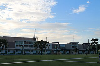
Greenfield District is a transit-oriented mixed-use development in Mandaluyong, Metro Manila, Philippines. It is a redevelopment of the old United Laboratories (Unilab) pharmaceutical plant and adjacent retail market in Barangay Highway Hills adjoining Barangay Kapitolyo in Pasig to the east. The 15-hectare (37-acre) mixed commercial and residential complex is in the crossroads of EDSA and Shaw Boulevard immediately south of the Ortigas Center financial district. It consists of an office tower, condominium high-rises, a central park, retail centers and recreational facilities.
Tres de Abril Street is a national tertiary road in Cebu City, Cebu, Philippines. It commences at Spolarium Street in Barangay Pasil which connects Barangay Ermita through the Forbes Bridge, passes through the junctions of C. Padilla Street and N. Bacalso Avenue, and ends at the junction of F. Llamas Street in Barangay Punta Princesa. It was formerly considered as a national secondary road under Executive Order No. 113 issued by President Ramon Magsaysay on May 2, 1955.
F. Llamas Street is a national tertiary road in Cebu City, Cebu, Philippines. It commences at N. Bacalso Avenue in Barangay Basak San Nicolas, passes through the junction of Tres de Abril and E. Sabellano streets and ends at the junction of Katipunan Street in Barangay Tisa. It was formerly considered as a "national aid" city road under Executive Order No. 113 issued by President Ramon Magsaysay on May 2, 1955.

Mariana, is an administrative division in eastern Metro Manila, the Philippines. It is an urban barangay in Quezon City in a middle class residential and commercial area known as New Manila, which includes Barangay Mariana and the adjacent barangays of Damayang Lagi, Horseshoe and Valencia.


