
Taguig, officially the City of Taguig, is the fifth-most populous city in the Philippines situated in eastern shores of Metro Manila, the national capital region. It is a center for culture, finance, technology, entertainment and media, academics, and the arts and fashion. The city hosts several embassies, making it an important center for the country's international diplomacy. As the home of Bonifacio Global City, major multinational corporations have their headquarters in the city, and it has the fourth largest skyline in the Philippines, with 289 high-rises, 80 of which exceed 100 m (328 ft).
General Tinio, formerly known as Papaya, officially the Municipality of General Tinio, is a municipality in the province of Nueva Ecija, Philippines. According to the 2020 census, it has a population of 55,925 people.
Salako is a hat from Îles des Saintes. It appeared towards the end of the 19th century. It is made on Terre-de-Bas Island by some last craftsmen who still have the art and the technics of its making.

Isla de la Convalecencia, commonly known as simply Isla de Convalecencia, is a small narrow river island in the Pasig River in Manila, the Philippines. It is the only island dividing the Pasig River in Manila located between the districts of San Miguel on the north bank, and Ermita and Paco on the south. The island, best known as the location of the Hospicio de San José, is administratively part of San Miguel's Barangay 646, Zone 67. It has a total area of approximately 594 square meters (6,390 sq ft) and is connected to both sides of the river by the Ayala Bridge.

The following is an alphabetical list of articles related to the Philippine capital region of Metro Manila.

Tunasan is a barangay in Muntinlupa, Philippines. It is the southernmost barangay of Metro Manila, located in the southern section of the city bordering the province of Laguna. The total land area of the barangay is 9.596 km2 (3.705 sq mi), the largest in the city. According to the 2020 census, it has a population of 61,374.
New Lower Bicutan, officially Barangay New Lower Bicutan, is one of the 38 barangays of Taguig, Metro Manila, Philippines. As of the 2020 census, the population was 55,928. The barangay was created through a plebiscite on December 28, 2008.

Central Signal Village, officially Barangay Central Signal Village and simply known as Central Signal, is one of the 38 barangays of Taguig, Philippines. As of the 2020 census, the population was 44,126. The barangay was previously known as EM's Signal Barrio on January 25, 1965, and was created as Signal Village in 1972, before it was renamed on December 28, 2008.

The National Shrine of Saint Joseph, commonly known as Mandaue Church, is a Roman Catholic parish church located at the center of Mandaue City, Philippines. It is under the jurisdiction of the Archdiocese of Cebu; its parish jurisdiction covers the civil barangays of Guizo, Centro, Looc, and Mantuyong.

Sucat is an administrative division in southern Metro Manila, Philippines. It is an urban barangay in Muntinlupa with many high-rise condominiums and commercial establishments. The area is also well-known for the Sucat exit of the South Luzon Expressway and Metro Manila Skyway.

South Signal Village, officially Barangay South Signal Village and simply known as South Signal, is one of the 38 barangays of Taguig, Philippines. As of the 2020 census, the population was 43,047. The barangay was created through a plebiscite on December 28, 2008.

San Martin de Porres is an administrative division in southern Metro Manila, the Philippines. It is an elongated barangay located in the northeast corner of Parañaque adjoining the areas of Bicutan in Taguig and northern Muntinlupa. It is unique in that it is connected to the rest of Parañaque by only two bridges, one of which is a footbridge. Its western border follows the South Luzon Expressway, thus separating it from Merville, Sun Valley, Don Bosco and Marcelo Green. It neighbors Western Bicutan to the north, particularly the redevelopment area of the former Food Terminal Inc. (FTI) known as Arca South. To the east, it adjoins Taguig's barangays of Upper Bicutan, Central Bicutan, North Daang Hari and Tanyag. It neighbors South Daang Hari and Sucat, Muntinlupa to the south.

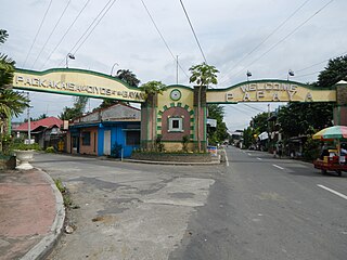
Santa Ana is one of the 38 barangays of Taguig, Metro Manila, Philippines. It is one of the nine original barrios of Taguig. It is named after Saint Anne, who is the patroness of the barangay.
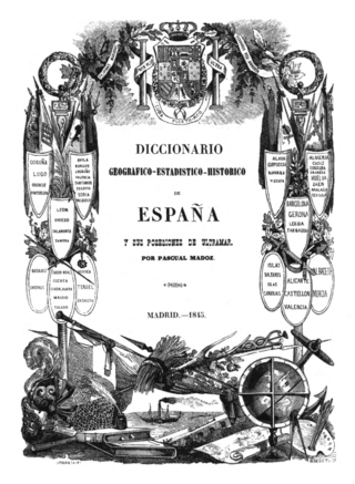
The Diccionario geográfico-estadístico-histórico de España y sus posesiones de Ultramar is a geographic handbook of Spain. Originally published in 16 volumes between 1845 and 1850, it was edited and directed by Pascual Madoz. A widely known work in Spain, used as reference work, it stands out in terms of the sheer amount of information, its systematization as well as for covering the whole geography of Spain.

Taguig–Pateros's 2nd congressional district is one of the two congressional districts of the Philippines in the combined independent local government units of Pateros and Taguig. The district is located entirely within the city of Taguig. It has been represented in the House of Representatives of the Philippines since 2007. The district was created in 2004 following a plebiscite to ratify Republic Act No. 8487 or the 1998 Taguig City Charter. It consists of the western Taguig barangays of Cembo, Central Bicutan, Central Signal Village, East Rembo, Fort Bonifacio, Katuparan, Maharlika Village, North Daang Hari, North Signal Village, Pinagsama, Pitogo, Post Proper Northside, Post Proper Southside, South Cembo, South Daang Hari, South Signal Village, Tanyag, Upper Bicutan, Western Bicutan, and West Rembo. The district is currently represented in the 19th Congress by Amparo Maria J. Zamora of the Lakas–CMD.

The Royal Company of the Philippines was a chartered company founded in 1785, directed to establish a monopoly on the Spanish Philippines and all surrounding trade. It weakened in importance until it was dissolved in the 1830s. Its direct predecessor was that of the Guipuzcoan Company of Caracas.

Ususan is one of the 38 barangays of Taguig, Philippines. As of 2020, it has a population of 53,956 people.

Local elections are scheduled to be held in Taguig on May 12, 2025, as part of the 2025 Philippine general election. The electorate will elect a mayor, a vice mayor, twenty-four members of the Taguig City Council, and two district representatives to the House of Representatives of the Philippines. The officials elected in the election will assume their respective offices on June 30, 2025, for a three-year-long term.


