Malate, Manila

Last updated

Malate
District of Manila
Roxas Boulevard, Malate - aerial view (Manila; 11-16-2019).jpg
Aerial view of Malate
Ph fil manila malate.png
Malate, Manila
Coordinates: 14°33′51″N120°59′29″E / 14.5641654°N 120.9913229°E / 14.5641654; 120.9913229
Country Philippines
Region National Capital Region
City Manila
Congressional districtsPart of the 5th district of Manila
Barangays 57
Area
  Total2.5958 km2 (1.0022 sq mi)
Population
 (2020) [1]
  Total99,257
Time zone UTC+08:00 (Philippine Standard Time)
Zip codes
1004
Area codes 2

Malate is a district of Manila, Philippines. Together with the district of Ermita, it serves as Manila's center for commerce and tourism.

Contents

Etymology

The name Malate is derived from a corruption of the Tagalog word maalat ("salty"). [2] The name likely referred to the brackish waters, where the river estuary (in today's Malate Estero) meets the bay.

Antonio Morga writing in 1609: "Manila has two drives for recreation. One is by land, along the point called Nuestra Señora de Guia. It extends for about a legua along the shore and is very clean and level. Thence it passes through a native street and settlement, called Bagunbayan, to a chapel, much frequented by the devout, called Nuestra Señora de Guia, and continues for a goodly distance further to a monastery and mission-house of the Augustinians, called Mahalat." [3]

Rizal who republished Morga's account, later annotated: "Better, Maalat. The Spaniards pronounced this later Malate. There lived the chief Tagáls after they were deprived of their houses in Manila, among whom were the families of Raja Matanda and Raja Soliman. San Augustín says that even in his day many of the ancient nobility dwelt there, and that they were very urbane and cultured. "The Men hold various positions in Manila, and certain occupations in some of the local public functions. The women make excellent lace, in which they are so skilful that the Dutch women cannot surpass them." This is still true of the women." [3]

History

View of Malate Church in 1831 View of Malate Church in 1831.jpg
View of Malate Church in 1831

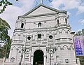
Malate was thought of as the place where the kings/high chiefs of Manila settled after losing their fort "Maynila" (now Intramuros) to the Spanish in 1571. [3] During most of the Spanish colonial period, Malate was an open space with a small fishing village. During the Spanish period, the center of activity was the Malate Church, dedicated to Our Lady of Remedies. It was bordered by Pasay to the south, San Andres Bukid to the east, shores of Manila Bay to the west, Paco to the northeast, Makati to the southeast, and Ermita to the north.

After the United States of America annexed the islands in 1898 as a consequence of the Spanish–American War, American urban planners envisioned the development of Malate as the newest and trendiest exclusive residential area for American families. American expatriates and some of the old Spanish mestizo families populated the district in modern high rise apartments and bungalows. In 1901, with the chartering of the city of Manila, [4] Malate would be absorbed by the city of Manila when its borders were extended outside Intramuros.

Despite extensive damage after the Second World War, many homes and buildings were still standing. The displaced wealthy families who evacuated their homes during the war returned and re-built their private villas and kept the whole district exclusively residential until the 1970s.

The once exclusive residential areas in western Malate began to transform into a commercial area with some large homes and residential apartments being converted into small hotels, specialty restaurants and cafes.

During the presidency of Ferdinand Marcos, visual and performing artists found a haven in Malate and it became a bohemian enclave.[ citation needed ]

The Malate was plot setting for the episode 'Mata' of the 2010 horror film Cinco.

List of barangays

ZonesBarangays
Zone 75Barangays 688, 689, 690, 691, 692, 693, 694, and 695
Zone 76Barangays 696, 697, 698, and 699
Zone 77Barangays 700, 701, 702, 703, 704, 705, and 706
Zone 78Barangays 707, 708, 709, 710, 711, 712, 713, 714, 715, 716, 717, 718, 719, 720, and 721
Zone 79Barangays 722, 723, 724, 725, 726, 727, 728, 729, and 730
Zone 80Barangays 731, 732, 733, 734, 735, 736, 737, 738, 739, 740, 741, 742, 743, and 744
Zone/BarangayLand area (km²)Population (2020 census)
Zone 75
Barangay 6880.04690 km²1,212
Barangay 6890.02462 km²733
Barangay 6900.01288 km²496
Barangay 6910.01467 km²409
Barangay 6920.03993 km²1,329
Barangay 6930.02784 km²511
Barangay 6940.07146 km²1,281
Barangay 6950.04763 km²654
Zone 76
Barangay 6960.08344 km²2,420
Barangay 6970.08563 km²1,967
Barangay 6980.08458 km²1,736
Barangay 6990.1955 km²3,193
Zone 77
Barangay 7000.03950 km²138
Barangay 7010.1914 km²2,695
Barangay 7020.04345 km²3,342
Barangay 7030.05857 km²114
Barangay 7040.03584 km²5,299
Barangay 7050.02287 km²2,683
Barangay 7060.04013 km²296
Zone 78
Barangay 7070.004390 km²1,052
Barangay 7080.02016 km²753
Barangay 7090.04385 km²4,154
Barangay 7100.01038 km²559
Barangay 7110.008760 km²1,294
Barangay 7120.01313 km²1,068
Barangay 7130.005250 km²1,964
Barangay 7140.01546 km²1,371
Barangay 7150.005370 km²180
Barangay 7160.004890 km²920
Barangay 7170.002740 km²479
Barangay 7180.008380 km²1,155
Barangay 7190.4977 km²6,690
Barangay 7200.05317 km²1,238
Barangay 7210.1336 km²577
Zone 79
Barangay 7220.02605 km²641
Barangay 7230.02234 km²540
Barangay 7240.08319 km²2,388
Barangay 7250.05289 km²1,409
Barangay 7260.04322 km²595
Barangay 7270.05788 km²1,790
Barangay 7280.07134 km²840
Barangay 7290.03145 km²871
Barangay 7300.04507 km²1,539
Zone 80
Barangay 7310.03627 km²2,916
Barangay 7320.02318 km²1,974
Barangay 7330.04084 km²4,303
Barangay 7340.01504 km²902
Barangay 7350.02234 km²2,063
Barangay 7360.01458 km²3,806
Barangay 7370.01198 km²2,209
Barangay 7380.03285 km²3,047
Barangay 7390.02586 km²4,530
Barangay 7400.02993 km²4,138
Barangay 7410.01402 km²1,207
Barangay 7420.007560 km²807
Barangay 7430.03766 km²1,607
Barangay 7440.03347 km²1,223

Accessibility

The district can be directly accessed by the main roads like the Roxas Boulevard, Quirino Avenue and Taft Avenue.

The Light Rail Transit LRT Line 1 (LRT-1) follows Taft Avenue and stops at two stations located in Malate, Vito Cruz and Quirino stations.

Economy

View of the Philippine Navy headquarters and the Manila Yacht Club Top view of the Philippine Navy Headquarters.jpg
View of the Philippine Navy headquarters and the Manila Yacht Club

Government offices

Agencies like the Department of Finance (DOF), the Bangko Sentral ng Pilipinas (BSP) and lending institution LandBank of the Philippines are headquartered in the district, whilst the National Naval Command Headquarters of the Philippine Navy is at the boundary limits of Manila and the city of Pasay along Roxas Boulevard. The Bureau of Plant Industry is also headquartered in the district.

The Apostolic Nunciature to the Philippines is located in the district along Taft Avenue near Quirino Avenue. This serves as the residence of the Pope during visits in the country.

Facilities

The Rizal Memorial Stadium Rizal Memorial Football Stadium - field, bleachers area (Malate, Manila; 11-27-2019).jpg
The Rizal Memorial Stadium

In the 1990s, Malate and the nearby district of Ermita had been "cleaned-up" and big businesses and resort hotels have sprouted in the district.

Harrison Plaza, Manila's first enclosed modern mall, was located in the Malate district.

There is one public hospital, the Ospital ng Maynila Medical Center, located at the corner of Roxas Boulevard and Quirino Avenue. It serves the 5th legislative district of Manila.

Recreation

The district is also home to the Philippine's first sports stadium, the Rizal Memorial Sports Complex and the country's premiere zoological park, the Manila Zoological and Botanical Garden. Promenades and parks by the Manila Bay have been made more convenient and safe with the opening of the Manila Baywalk area and the renovated Plaza Rajah Sulayman. A portion of the Cultural Center of the Philippines Complex also lies within the district.

The district contains a red-light district. [5] A Koreatown could also be found in the district. [6] [7] [8]

Education and scholarly activity

St. La Salle Hall and Henry Sy Sr. Hall of De La Salle University Ph-mm-manila-malate-taft ave.-de la salle university (dlsu)-saint la salle hall; henry sy bldg. (2014).JPG
St. La Salle Hall and Henry Sy Sr. Hall of De La Salle University

Education in Malate is mostly provided by private schools. Several educational institutions which are part of the University Belt are located in Malate, these are the De La Salle University, De La Salle – College of Saint Benilde, Philippine Christian University, Philippine Women's University, St. Paul University Manila and St. Scholastica's College Manila. Prominent secondary schools in Malate are the Jesus Reigns Christian Academy, Jose Abad Santos Memorial School and the Malate Catholic School. Doña Aurora Quezon Elementary School is the only public school in the district.

Notable residents

Notes

Related Research Articles

<span class="mw-page-title-main">Ermita</span> District of Manila, Metro Manila, Philippines

Ermita is a district in Manila, Philippines. Located at the central part of the city, the district is a significant center of finance, education, culture, and commerce. Ermita serves as the civic center of the city, bearing the seat of city government and a large portion of the area's employment, business, and entertainment activities.

<span class="mw-page-title-main">Pasay</span> Highly urbanized city in Metro Manila, Philippines

Pasay, officially the City of Pasay, is a 1st class highly urbanized city in the National Capital Region of the Philippines. According to the 2020 census, it has a population of 440,656 people.

<span class="mw-page-title-main">University Belt</span> Academic district in Manila, Philippines

The University Belt is the name of a de facto subdistrict in Manila, Philippines, referring to an area that has a significant concentration of major colleges and universities in the city. The districts of Quiapo, Sampaloc, and San Miguel are traditionally considered to be the University Belt, although other clusters of schools that lie along the southern bank of the Pasig River, mostly at the districts of Intramuros and Ermita, as well as the southernmost part of Malate near the city limits are also sometimes included. Each of the colleges and universities found in the district are a short walking distance of each other.

<span class="mw-page-title-main">Roxas Boulevard</span> Major street in Metro Manila, Philippines

Roxas Boulevard is a popular waterfront promenade in Metro Manila in the Philippines. The boulevard, which runs along the shores of Manila Bay, is well known for its sunsets and stretch of coconut trees. The divided roadway has become a trademark of Philippine tourism, famed for its yacht club, hotels, restaurants, commercial buildings and parks.

<span class="mw-page-title-main">Radial Road 1</span> Route in Metro Manila

Radial Road 1 (R-1), informally known as the R-1 Road, is a network of roads and bridges that all together form the first arterial road of Metro Manila in the Philippines. Spanning some 42.67 kilometers (26.51 mi), it connects the cities and municipalities of Bacoor, General Trias, Imus, Kawit, Las Piñas, Manila, Naic, Noveleta, Parañaque, Pasay, and Tanza in Cavite and Metro Manila.

<span class="mw-page-title-main">Taft Avenue</span> Major street in Metro Manila, Philippines

Taft Avenue is a major road in the south of Metro Manila. It passes through three cities in the metropolis: Manila, Pasay, and Parañaque. The road was named after the former Governor-General of the Philippines and U.S. President, William Howard Taft; the Philippines was a former commonwealth territory of the United States in the first half of the 20th century. The avenue is a component of National Route 170 (N170), a secondary road in the Philippine highway network, and anchors R-2 of the Manila arterial road network.

<span class="mw-page-title-main">Tourism in Metro Manila</span>

In Metro Manila, Philippines, tourism is a significant industry. In 2012, the city and the region welcomed 974,379 overnight visitors. Serving as the main gateway to the Philippines' numerous destinations, the city attracts mainly international tourists, with a total of 3,139,756 visitors in 2012. Global Blue ranks Manila as the eleventh 'Best Shopping Destination' in Asia. The city holds the tenth position in MasterCard's global top 20 fastest-growing cities for international visitors from 2009 to 2013.

<span class="mw-page-title-main">Plaza Rajah Sulayman</span>

Plaza Rajah Sulayman, also known as Rajah Sulayman Park, is a public square in Malate, Manila. It is bounded by Roxas Boulevard to the west, San Andres Street to the south, and Remedios Street to the north. The plaza is considered the center of Malate as it fronts the Malate Church, the main church of the district.

<span class="mw-page-title-main">Gil Puyat Avenue</span> Road in the Philippines

Senator Gil J. Puyat Avenue, also known simply as Gil Puyat Avenue and by its former official name Buendia Avenue, is a major arterial thoroughfare which travels east–west through the cities of Makati and Pasay in western Metro Manila, Philippines. It is one of the busiest avenues in Metro Manila linking the Makati Central Business District with the rest of the metropolis.

<span class="mw-page-title-main">United Nations Avenue</span> Avenue in Manila, Philippines

United Nations Avenue is a major thoroughfare in Manila, Philippines. A commercial, residential and industrial artery, the avenue runs east–west through the near-center of the city linking Ermita and Rizal Park with the eastern districts. It is home to the World Health Organization Western Pacific headquarters.

<span class="mw-page-title-main">Pablo Ocampo Street</span> Street in Metro Manila, Philippines

Pablo Ocampo Street, also known simply as Ocampo Street and formerly and still referred to as Vito Cruz Street, is an inner city main road in Manila, Philippines. It runs west–east for about 3.448 kilometers (2.142 mi) connecting the southern districts of Malate and San Andres southeast to the adjacent city of Makati.

<span class="mw-page-title-main">Pedro Gil Street</span> Street in Manila, Philippines

Pedro Gil Street is an east-west inner city street and a tertiary national road in south-central Manila, Philippines. It is 3.65 kilometers (2.27 mi) long and spans the entire length of Ermita, Malate, Paco, and Santa Ana. The street is served by the Pedro Gil LRT Station along Taft Avenue and the Paco railway station along Quirino Avenue. It also continues towards the central Metro Manila cities of Mandaluyong and San Juan across the Pasig River as New Panaderos and General Kalentong Streets.

<span class="mw-page-title-main">Kalaw Avenue</span> Street in Manila, Philippines

Kalaw Avenue is a short stretch of road in the Ermita district of Manila, Philippines. It forms the southern boundary of Rizal Park running east–west from San Marcelino Street to Roxas Boulevard near the center of the city. It begins as a four-lane road at the intersection with San Marcelino widening to an eight-lane divided roadway along the stretch of Rizal Park from Taft Avenue west to Roxas Boulevard. It has a short extension into the reclaimed area of Luneta and Quirino Grandstand as South Drive. The avenue's main section between Taft Avenue and Roxas Boulevard is assigned as National Route 155 (N155) of the Philippine highway network.

<span class="mw-page-title-main">Quirino Avenue</span> Major street in Manila, Philippines

President Elpidio Quirino Avenue, more commonly known as Quirino Avenue, is a 6-10 lane divided highway in Manila, Philippines. It runs for 3.6 kilometers (2.2 mi) in a northeast–southwest direction from Nagtahan Bridge across from Santa Mesa in the north to Roxas Boulevard in Malate in the south. It passes through Paco and Pandacan districts where it also serves as a truck route between Port Area and South Luzon Expressway. North of Nagtahan Bridge, the road continues as Nagtahan Street. It is designated as part of Circumferential Road 2.

<span class="mw-page-title-main">Remedios Circle</span> Road junction in Manila, Philippines

Remedios Circle, also known as the Plaza de la Virgen de los Remedios, Remedios Rotonda, and Rotary Circle, is a traffic circle in Malate, Manila in the Philippines, serving as the intersection between Remedios Street, Jorge Bocobo Street and Adriatico Street. The circle and a traversing street are both named after Nuestra Señora de los Remedios, the patroness of the nearby Malate Church, and is one of two major open spaces in Malate, the other being Plaza Rajah Sulayman.

<span class="mw-page-title-main">Harrison Avenue</span>

Francis Burton Harrison Avenue, commonly known as F. B. Harrison Avenue or Harrison Avenue, is a major north-south collector road in Pasay, western Metro Manila, Philippines. It is a four-lane undivided arterial running parallel to Roxas Boulevard to the west and Taft Avenue to the east, from Pasay's border with Malate district in the north to Baclaran in Parañaque in the south. The avenue is named for U.S. Governor-General of the Philippines, Francis Burton Harrison.

<span class="mw-page-title-main">Del Pilar Street</span>

Marcelo H. del Pilar Street, also known as M.H. del Pilar Street or simply Del Pilar Street, is a north–south road running for 1.895 kilometers (1.177 mi) connecting Ermita and Malate districts in Manila, Philippines. It is a two-lane street which carries traffic one-way southbound from Kalaw Avenue in Rizal Park to Quirino Avenue just across from the Ospital ng Maynila. It was formerly called Calle Real.

<span class="mw-page-title-main">Elpidio Quirino Avenue</span>

Elpidio Quirino Avenue, also known simply as Quirino Avenue, is a major north-south collector road in Parañaque, southern Metro Manila, Philippines. It is a four-lane undivided arterial running parallel to Roxas Boulevard and its extension, the Manila–Cavite Expressway, to the west from Baclaran at Parañaque's border with Pasay in the north to San Dionisio right by the border with Las Piñas in the south. It is a continuation of Harrison Avenue from Pasay and was originally a segment of the coastal highway called Calle Real. The entire road is a component of Radial Road 2 (R-2) of Manila's arterial road network, while its segment south of NAIA Road is a component of National Route 62 (N62) of the Philippine highway network. It was named after President Elpidio Quirino. The road's name is also applied alternatively to Diego Cera Avenue in Las Piñas.

<span class="mw-page-title-main">Index of Metro Manila–related articles</span>

The following is an alphabetical list of articles related to the Philippine capital region of Metro Manila.

References

  1. "2020 Census of Population and Housing Results" (PDF). Philippine Statistics Authority. August 16, 2021. Retrieved April 7, 2023.
  2. Lesho, Marivic; Sippola, Eeva (2018). "Toponyms in Manila and Cavite, Philippines". Vergleichende Kolonialtoponomastik Strukturen und Funktionen kolonialer Ortsbenennung. De Gruyter. pp. 317–332. ISBN   9783110608618.
  3. 1 2 3 Blair, Emma (1906). The Philippine Islands, 1493-1898 Vol. 15. Arthur H. Clark Company.
  4. "An act to incorporate the City of Manila". Act No. 183 of July 31, 1901 . Retrieved June 6, 2022.
  5. "Starter Guide To Manila Red Light District". A Farang Abroad. Retrieved January 31, 2019.
  6. Severo, Jan Milo (March 11, 2021). "'Korea Town' soon to rise in Malate, Manila". Philstar.com. Retrieved February 12, 2022.
  7. "What to expect from Manila Koreatown in Malate". ABS-CBN News. June 16, 2021. Retrieved February 12, 2022.
  8. "MANILA KOREATOWN OPENS IN MALATE". Manila: Philippine Daily Inquirer. June 27, 2021. Retrieved March 21, 2022.