Camp General Emilio Aguinaldo (CGEA; formerly Camp Murphy), also known as Camp Aguinaldo, is the site of the general headquarters (GHQ) of the Armed Forces of the Philippines (AFP).
The combined areas of both Camp Aguinaldo and Camp Crame covers a total land area of 220 hectares (2.2km2), with 34 hectares (0.34km2) being part of a deed of donation from the Ortigas and Company Partnership Limited in the 1950s. The company had originally acquired these lands as estate holdings from the Augustinian Order, such as the Hacienda de Mandaluyon.[1]
Camp Aguinaldo occupies 178.7 hectares (1.787km2) of this total area,[2] of which 152.5 hectares (1.525km2) hectares were purchased by the government and the remaining 26.2 hectares (0.262km2) hectares were donated by Ortigas and Company.[3][4]
History
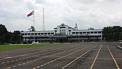
Aerial view of Camp Murphy and Zablan Field, 1937Gate of Camp Aguinaldo.GHQ Security Escort Battalion render honors for United States Secretary of DefenseWilliam Cohen at the Camp Aguinaldo Grandstand and Parade Ground.
In June 1938, the Army Constabulary Division was separated from the Philippine Army and was reformed to become the National Police Force under the Department of Interior.[9]
After World War II, Camp Murphy was divided into two camps—Camp Crame and Camp Aguinaldo. The Zablan Field's former Japanese runways now forms the roads of White Plains Avenue and a portion of Katipunan Avenue, just in front of White Plains subdivisions.[10] The camp was transferred to the jurisdiction of Quezon City in 1941,[11][12] and briefly became part of the City of Greater Manila, resulting from Quezon City's merger with Manila and several Rizal towns, from 1942 to 1945.[13][14]
During the EDSA Revolution in February 1986, Camp Aguinaldo, along with Camp Crame, were targeted by the Reform the Armed Forces Movement (RAM) - a cabal of disgruntled officers of the Armed Forces of the Philippines (AFP) led by RAM founder Col. Gringo Honasan as key strategic facilities to restrict counteroffensive from Marcos-loyal troops as a part of a coup attempt against Ferdinand and Imelda Marcos, however the coup was quickly uncovered and was ultimately aborted.[15]
On November 21, 2013, Civic Groups and Volunteers were to be transferred to Camp Emilio Aguinaldo from Villamor Air Base in Pasay. It was done to give more storage spaces for those who were part of Oplan Salubong. All relief supports including food, medical and transportation services were to be transferred to Camp Aguinaldo together with the DSWD in the benefit of Typhoon Yolanda survivors.[16][17][18][19]
The military installation is situated in its own administrative division as a barangay of Quezon City, known as Barangay Camp Aguinaldo. Prior to this, Camp Aguinaldo was part of Barangay Socorro until the namesake barangay was created through Executive Order No. 29 signed by MayorNorberto S. Amoranto on June 25, 1975. At the time of creation, the barangay had 250 households and a voting population of 800 people.[23]
The land boundaries of Barangay Camp Aguinaldo are defined by Boni Serrano Avenue (formerly known as Santolan Road) to the north, EDSA to the west, White Plains Avenue to the south, and the eastern perimeter of the base to the east. [21] Some non-military establishments can be found near the northern boundary with Barangay Socorro along Boni Serrano Avenue, such as the Saint Ignatius de Loyola Parish Church and the Camp General Emilio Aguinaldo High School.
Its barangay hall can be located at the intersection of Road 3 and Gozar Street.[21]
This page is based on this Wikipedia article Text is available under the CC BY-SA 4.0 license; additional terms may apply. Images, videos and audio are available under their respective licenses.