
Makati, officially the City of Makati, is a highly urbanized city in the National Capital Region of the Philippines, known for being one of the leading financial centers in the country. As of 2013, the city has the highest concentration of multinational and local corporations in the Philippines. Major banks, corporations, department stores as well as foreign embassies are based in Makati. Makati is also known for being a major cultural and entertainment hub in Metro Manila. According to the 2020 census, it had a population of 629,616 people, making it the 47th most populous city in the country and 8th most populous in Metro Manila. Makati is one of the most densely populated city proper areas globally, ranking 8th worldwide and 2nd in the Philippines, after Manila, with a population density of 28,975 inhabitants per square kilometer.

Pateros, officially the Municipality of Pateros, is the lone municipality of Metro Manila, Philippines. According to the 2020 census, it has a population of 65,227 people.

Taguig, officially the City of Taguig, is the fifth-most populous city in the Philippines situated in eastern shores of Metro Manila, the national capital region. It is a center for culture, finance, technology, entertainment and media, academics, and the arts and fashion. The city hosts several embassies, making it an important center for the country's international diplomacy. As the home of Bonifacio Global City, major multinational corporations have their headquarters in the city, and it has the fourth largest skyline in the Philippines, with 289 high-rises, 80 of which exceed 100 m (328 ft).
The legislative districts of Makati are the representations of the highly urbanized city of Makati in the various national legislatures of the Philippines. The city is currently represented in the lower house of the Congress of the Philippines through its first and second districts.

Upper Bicutan is one of the 38 barangays of Taguig, Metro Manila in the Philippines.
New Lower Bicutan, officially Barangay New Lower Bicutan, is one of the 38 barangays of Taguig, Metro Manila, Philippines. As of the 2020 census, the population was 55,928. The barangay was created through a plebiscite on December 28, 2008.

Bambang, officially Barangay Bambang, is one of the 38 barangays of Taguig, Philippines. As of the 2020 census, the population was 13,949. Located near the Taguig River, it is one of the nine original barrios of the city when the latter was first established on April 25, 1587.

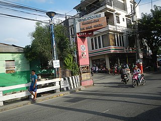
Pinagsama is an urban barangay in Taguig, Metro Manila, Philippines. It is located in the western part of Taguig and is

Maharlika Village, officially Barangay Maharlika and simply known as Maharlika, is one of the 38 barangays of Taguig, Metro Manila, Philippines. As of the 2020 census, the population was 23,470. The barangay, which was created from the land that was excluded out of AFP Enlisted Men's Village on January 3, 1974, has the largest Muslim community in Metro Manila.

Western Bicutan is one of the 38 barangays of Taguig, Philippines. It is the city's most populated barangay and the largest in terms of land area. It is located in the northwestern part of the city. Arca South, Food Terminal Inc., Technological University of the Philippines – Taguig, the southern portion of Naval Station Jose Francisco, Philippine Navy Golf Club, AFPOVAI, Libingan ng mga Bayani, Taguig-Pateros District Hospital, Veterans Museum, and TESDA headquarters are located in the barangay.

South Signal Village, officially Barangay South Signal Village and simply known as South Signal, is one of the 38 barangays of Taguig, Philippines. As of the 2020 census, the population was 43,047. The barangay was created through a plebiscite on December 28, 2008.

Napindan, officially Barangay Napindan, is one of the 38 barangays of Taguig, Metro Manila, Philippines. As of the 2020 census, the population was 24,437. It was one of the earlier barrios that was added to Taguig during the Spanish colonial period.

Fort Bonifacio is one of the 38 barangays of Taguig, Philippines. The financial district of Bonifacio Global City, the Fort Bonifacio military camp and the Manila American Cemetery are under the jurisdiction of the barangay.

Santo Niño is a barangay located in Parañaque, Metro Manila, Philippines. The barangay surrounds the Ninoy Aquino International Airport on its west and south sides, with a large portion of the barangay extending into the property of the airport grounds to include Terminal 1 as well as the western half of Runway 06/24. The barangay has a total land area of 245.97 hectares of which about 55% is occupied by the airport complex. Its population is concentrated in the areas along the Estero de Tripa de Gallina.

San Martin de Porres is an administrative division in southern Metro Manila, the Philippines. It is an elongated barangay located in the northeast corner of Parañaque adjoining the areas of Bicutan in Taguig and northern Muntinlupa. It is unique in that it is connected to the rest of Parañaque by only two bridges, one of which is a footbridge. Its western border follows the South Luzon Expressway, thus separating it from Merville, Sun Valley, Don Bosco and Marcelo Green. It neighbors Western Bicutan to the north, particularly the redevelopment area of the former Food Terminal Inc. (FTI) known as Arca South. To the east, it adjoins Taguig's barangays of Upper Bicutan, Central Bicutan, North Daang Hari and Tanyag. It neighbors South Daang Hari and Sucat, Muntinlupa to the south.

Post Proper Southside, also known as Post Proper South Fort Bonifacio, Barangay 31, or simply Southside, is one of the 38 barangays of Taguig, Philippines. It is one of the ten Embo barangays, and one of the two Inner Fort Bonifacio barangays, the other one being the Post Proper Northside. It was established in 1972 as a barangay under Makati, and its de facto territory consists of multiple exclaves mostly within Palar Village of Barangay Pinagsama and settlements along the Consular Road area between McKinley West of the Bonifacio Capital District and Bonifacio Global City (BGC) in Barangay Fort Bonifacio, Taguig. It also has the Fort Andres Bonifacio military camp.

Taguig–Pateros's 2nd congressional district is one of the two congressional districts of the Philippines in the combined independent local government units of Pateros and Taguig. The district is located entirely within the city of Taguig. It has been represented in the House of Representatives of the Philippines since 2007. The district was created in 2004 following a plebiscite to ratify Republic Act No. 8487 or the 1998 Taguig City Charter. It consists of the western Taguig barangays of Cembo, Central Bicutan, Central Signal Village, East Rembo, Fort Bonifacio, Katuparan, Maharlika Village, North Daang Hari, North Signal Village, Pinagsama, Pitogo, Post Proper Northside, Post Proper Southside, South Cembo, South Daang Hari, South Signal Village, Tanyag, Upper Bicutan, Western Bicutan, and West Rembo. The district is currently represented in the 19th Congress by Amparo Maria J. Zamora of the Lakas–CMD.

The Enlisted Men's Barrio, commonly known as Embo, refers to the collective term for ten barangays in Taguig, Philippines. It is made up of barangays Cembo, Comembo, East Rembo, Pembo, Pitogo, Rizal, South Cembo and West Rembo, as well as the two Inner Fort barangays: Post Proper Northside and Post Proper Southside. The barangays were originally established to house military personnel of the Armed Forces of the Philippines (AFP).

Ususan is one of the 38 barangays of Taguig, Philippines. As of 2020, it has a population of 53,956 people.

Hagonoy, officially Barangay Hagonoy, is one of the 38 barangays of Taguig, Metro Manila, Philippines. As of the 2020 census, the population was 21,693. It had since existed before the arrival of Spaniards to the country and was originally one of the nine barrios that formed Taguig after the latter was established on April 25, 1587.


