City of Greater Manila

Last updated

City of Greater Manila
Lungsod ng Kalakhang Maynila (Tagalog)
Ciudad de Gran Manila (Spanish)
大マニラ市 Dai Manira-shi (Japanese)
Chartered city of the Philippines
1942–1945
City of Greater Manila map.jpg
Map of the historical city of Greater Manila
Government
Mayor  
 December 24, 1941 – January 26, 1942
Jorge B. Vargas
 January 27, 1942 – July 17, 1944
León Guinto
Historical era World War II
 Established
1 January 1942
 Disestablished
1 August 1945
Preceded by
Succeeded by
Flag of the Philippines (1936-1985, 1986-1998).svg Manila (city)
Flag of the Philippines (1936-1985, 1986-1998).svg Rizal
Manila (city) Flag of the Philippines (1936-1985, 1986-1998).svg
Rizal Flag of the Philippines (1936-1985, 1986-1998).svg
Today part of Metro Manila

Greater Manila, officially the City of Greater Manila and sometimes referred to as the Greater Manila Area (GMA), [1] was a chartered city [2] that existed during the Japanese occupation of the Philippines in World War II, from 1942 to 1945. Governed by the Commonwealth of the Philippines, it served as a model for the present-day Metro Manila and the administrative functions of the governor of Metro Manila—both established three decades later during the administration of President Ferdinand Marcos. It was a merger of Manila, Quezon City, and the then-Rizal towns of Caloocan, Makati, Mandaluyong, Parañaque, Pasay, and San Juan, all present parts of Metro Manila.

Contents

History

Greater Manila was formed on January 1, 1942, by virtue of Executive Order No. 400 signed by President Manuel L. Quezon as an emergency measure. It was a merger of the cities of Manila and Quezon and the then-Rizal towns of Caloocan, Makati, Mandaluyong, Parañaque, Pasay, and San Juan. [2] [3] During that time, Manila served as the capital of the Philippines during the Japanese-sponsored Second Philippine Republic. Japanese forces occupied Manila on January 2, 1942. [4]

On July 26, 1945, President Sergio Osmeña signed Executive Order No. 58, leading to the reduction of territories and the eventual dissolution of Greater Manila effective August 1. The cities and towns that were part of the city then regained their respective pre-war status. [5]

Composition

Greater Manila was a merger of Manila, Quezon City, and the Rizal municipalities of Caloocan, Makati, Mandaluyong, Parañaque, Pasay, and San Juan, all parts of the present-day Metro Manila.

Manila was divided into four districts: Bagumbuhay, Bagumpanahon, Bagumbayan, and Bagungdiwa. Bagumbuhay encompassed Binondo, San Nicolas, Tondo, and the northern portion of Santa Cruz. Bagumpanahon encompassed of the rest of Santa Cruz, Quiapo, Sampaloc (including the present-day Santa Mesa), and San Miguel. Bagumbayan encompassed of Ermita, Intramuros, Malate, Port Area, and the western portion of Paco. Bagungdiwa encompassed of the eastern portion of Paco, Pandacan, and Santa Ana (including the present-day San Andres).

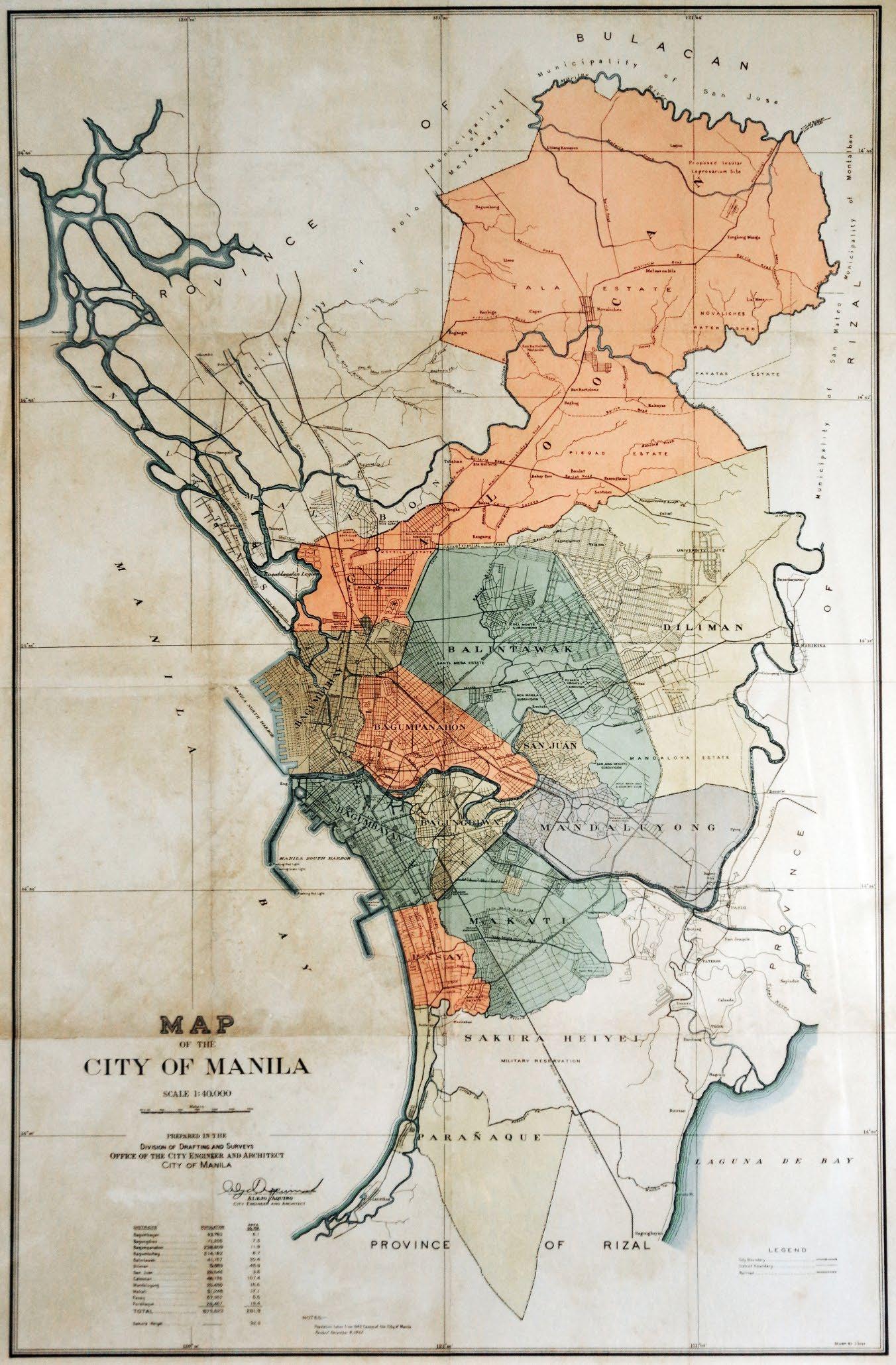
Quezon City was divided into two districts: Balintawak and Diliman, bisected by the Manila Circumferential Road (now EDSA). Balintawak, located west and south of the road, also included Mandaloya Estate, which encompasses the present-day northeastern part of Mandaluyong (including Wack Wack Golf and Country Club) and the present-day eastern part of San Juan (including Greenhills). The city then excluded its present-day northern portion, which was then part of Caloocan and San Mateo, Rizal.

Regarding the municipalities ceded from Rizal, Caloocan, which was then undivided, included the Cocomo Island, which includes what is now San Rafael Village, Navotas, but excluded the now-reclaimed Dagat-dagatan Lagoon and parts of Libis-Baesa, then under Malabon. Mandaluyong also included what is now the western portion of Pasig, west of the Marikina River. The Sakura Heiyei military reservation, which included the Nichols Field (now part of Pasay), Fort McKinley (now Fort Bonifacio), and the present-day eastern portion of Parañaque, were not part of Greater Manila. [6] [7]

Government

Greater Manila was headed by the mayor of Greater Manila. Jorge B. Vargas assumed the mayoralty post in December 1941, later appointing León Guinto as his successor in January 1942. The mayors of the constituent towns and cities became assistant mayors (equivalent to present-day vice mayors) within the consolidated city, all under the mayor of Greater Manila. [3] [7] The city was also represented in the National Assembly of the Japanese-sponsored Second Philippine Republic under the at-large district of Manila.

See also

Related Research Articles

<span class="mw-page-title-main">Metro Manila</span> Metropolitan area and region of the Philippines

Metropolitan Manila, commonly shortened to Metro Manila and formally the National Capital Region, is the capital region and largest metropolitan area of the Philippines. Located on the eastern shore of Manila Bay, the region lies between the Central Luzon and Calabarzon regions. Encompassing an area of 636.00 km2 (245.56 sq mi) and with a population of 13,484,462 as of 2020, it is composed of sixteen highly urbanized cities: the capital city, Manila, Caloocan, Las Piñas, Makati, Malabon, Mandaluyong, Marikina, Muntinlupa, Navotas, Parañaque, Pasay, Pasig, Quezon City, San Juan, Taguig, and Valenzuela, along with one independent municipality, Pateros. As the second most populous and the most densely populated region in the Philippines, it ranks as the 9th most populous metropolitan area in Asia and the 6th most populous urban area in the world.

<span class="mw-page-title-main">Rizal (province)</span> Province in Calabarzon, Philippines

Rizal, officially the Province of Rizal, is a province in the Philippines located in the Calabarzon region in Luzon. Its capital is the city of Antipolo. It is about 16 kilometers (9.9 mi) east of Manila. The province is named after José Rizal, one of the main national heroes of the Philippines. It is bordered by Metro Manila to the west, Bulacan to the north, Quezon to the east and Laguna to the southeast. The province also lies on the northern shores of Laguna de Bay, the largest lake in the country. Rizal is a mountainous province perched on the western slopes of the southern portion of the Sierra Madre mountain range.

<span class="mw-page-title-main">Pasay</span> Highly urbanized city in Metro Manila, Philippines

Pasay, officially the City of Pasay, is a highly urbanized city in the National Capital Region of the Philippines. According to the 2020 census, it has a population of 440,656 people.

<span class="mw-page-title-main">EDSA</span> Limited-access circumferential highway around Metro Manila

Epifanio de los Santos Avenue, commonly referred to by its acronym EDSA, is a limited-access circumferential highway around Manila, the capital city of the Philippines. It passes through 6 of Metro Manila's 17 local government units or cities, namely, from north to south, Caloocan, Quezon City, San Juan, Mandaluyong, Makati, and Pasay.

<span class="mw-page-title-main">Pan-Philippine Highway</span> Highway in the Philippines traversing most of the country

The Pan-Philippine Highway, also known as the Maharlika Highway, is a network of roads, expressways, bridges, and ferry services that connect the islands of Luzon, Samar, Leyte, and Mindanao in the Philippines, serving as the country's principal transport backbone. Measuring 3,379.73 kilometers (2,100.07 mi) long excluding sea routes not counted by highway milestones, it is the longest road in the Philippines that forms the country's north–south backbone component of National Route 1 (N1) of the Philippine highway network. The entire highway is designated as Asian Highway 26 (AH26) of the Asian Highway Network.

<span class="mw-page-title-main">Mega Manila</span> Megalopolis in the Philippines

Mega Manila is a megalopolis on the island of Luzon in the Philippines. There are varying definitions of the megalopolis, but it is generally seen as encompassing the administrative regions of Central Luzon, Calabarzon, and Metro Manila. On some occasions, the administrative region of Mimaropa is also included.

<span class="mw-page-title-main">Legislative districts of Manila</span> Legislative district of the Philippines

The highly urbanized city of Manila is currently represented in the House of Representatives of the Philippines by its six congressional districts. Every three years, each district elects one representative who will sit on their behalf in Congress. In addition, each district is allotted six seats in the Manila City Council, with councilors being elected every three years.

<span class="mw-page-title-main">Legislative districts of Rizal</span> Legislative district of the Philippines

The legislative districts of Rizal are the representations of the province of Rizal in the various national and local legislatures of the Philippines. At present, the province is represented in the House of Representatives of the Philippines by its four congressional districts, with the districts' representatives being elected every three years. Additionally, each district is allotted a certain number of seats in the Rizal Provincial Board, with board members also being elected every three years.

The National Assembly was the legislature of the Second Philippine Republic from September 25, 1943, to February 2, 1944.

The geography of the City of Manila is characterized by its coastal position at the estuary of the Pasig River that flows to Manila Bay. The city is located on a naturally protected harbor, regarded as one of the finest harbors in Asia. The scarce availability of land is a contributing factor that makes Manila the densest populated city in the world.

<span class="mw-page-title-main">Manila (province)</span> Philippine province (1571–1901)

Manila, also known as Tondo until 1859, was a province of the Philippines that encompassed the former pre-Hispanic polities of Tondo, Maynila, and Namayan. In 1898, it comprised the city of Manila and 23 other municipalities. In 1901, the province was dissolved, with the city of Manila absorbing six of its smaller neighboring municipalities. The remaining part was merged with the adjacent district of Morong to form the province of Rizal.

<span class="mw-page-title-main">Circumferential Road 4</span> Beltway road in Metro Manila, Philippines

Circumferential Road 4 (C-4), informally known as the C-4 Road, is a network of roads and bridges that all together form the fourth beltway of Metro Manila in the Philippines. Spanning some 27.35 kilometers (16.99 mi), it connects the cities of Caloocan, Makati, Malabon, Mandaluyong, Navotas, Pasay, Quezon City, and San Juan.

Metro Manila, the capital region of the Philippines, is a large metropolitan area that has several levels of subdivisions. Administratively, the region is divided into seventeen primary local government units with their own separate elected mayors and councils who are coordinated by the Metropolitan Manila Development Authority, a national government agency headed by a chairperson directly appointed by the Philippine president. The cities and municipality that form the region's local government units are further divided into several barangays or villages which are headed by an elected barangay captain and barangay council.

<span class="mw-page-title-main">Outline of Metro Manila</span> Overview of and topical guide to Metro Manila

The following outline is provided as an overview of and topical guide to Metro Manila:

<span class="mw-page-title-main">Index of Metro Manila–related articles</span>

The following is an alphabetical list of articles related to the Philippine capital region of Metro Manila.

<span class="mw-page-title-main">Rizal's 1st congressional district</span> Legislative district of the Philippines

Rizal's 1st congressional district is one of the four congressional districts of the Philippines in the province of Rizal. It has been represented in the House of Representatives of the Philippines since 1916 and earlier in the Philippine Assembly from 1907 to 1916. The district consists of the western Rizal municipalities of Angono, Binangonan, Cainta and Taytay. It is presently the largest legislative district in the country in terms of population. It is currently represented in the 19th Congress by Michael John R. Duavit of the Nationalist People's Coalition (NPC).

References

  1. "Chapter I". Quezon City at 75 Resurgent & Resilient. Erehwon Artworld Corporation for the Local Government of Quezon City through the Communications Coordination Center. 2014. p. 69. ISBN   9789719566632.
  2. 1 2 Philippines (1942). "Chartered Cities". Official Gazette of the Republic of the Philippines . 1 (4): 200.
  3. 1 2 Executive Order No. 400, s. 1942 (January 1, 1942), Creating the City of Greater Manila, Official Gazette of the Republic of the Philippines, archived from the original on July 1, 2022, retrieved August 24, 2022
  4. Horner, David (January 15, 2010). World War II: The Pacific. The Rosen Publishing Group, Inc. p. 30. ISBN   978-1-4358-9133-3 . Retrieved March 27, 2022.
  5. Executive Order No. 58, s. 1945 (July 25, 1945), Reducing the Territory of the City of Greater Manila, Official Gazette of the Republic of the Philippines, archived from the original on March 8, 2023, retrieved August 24, 2022
  6. Map of the City of Manila (Map). 1:40,000. Division of Drafting and Surveys, Office of the City Engineer and Architect, City of Manila. 1942. Retrieved August 24, 2022.
  7. 1 2 "Historical Background". DENR - Environment Management Bureau - National Capital Region. Retrieved May 28, 2022.
Preceded by Capital of the Second Philippine Republic
1942–1944
Succeeded by