Mega Manila | |
---|---|
Country | Philippines |
Regions | Calabarzon Central Luzon Metro Manila Mimaropa (except Palawan) |
Area | |
• Metro | 50,525 km2 (19,508 sq mi) |
Population | |
• Metro | 41,099,507 |
• Metro density | 810/km2 (2,100/sq mi) |
GDP | |
• Metro | ₱ 14.131 trillion US$ 254.364 billion (2023) |
• Per capita | ₱ 345,000 US$ 6,200 (2023) |
Mega Manila is a megalopolis on the island of Luzon in the Philippines. There are varying definitions of the megalopolis, but it is generally seen as encompassing the administrative regions of Central Luzon, Calabarzon, and Metro Manila. On some occasions, the administrative region of Mimaropa (excluding Palawan) is also included.
It is frequently used in the press, advertising, television, and radio to refer to provinces bound to Manila, in contrast to the term Greater Manila Area, which is academically used to describe the urbanization process that has long spilled out of Metro Manila's borders, also known as the built-up area. Mapping out the built-up area around Manila requires finer granularity than the more generic term Mega Manila.
It is also being used more and more recently in planning for infrastructure projects by the government, particularly by the National Economic and Development Authority (NEDA) and the Japan International Cooperation Agency (JICA).
Mega Manila is used in general reference to the relationship of Metro Manila to the surrounding provinces. It references only provinces and not the exact settlement patterns of cities, towns, and barangays, which may be urban, suburban, mountainous, or rural areas that are still part of provinces close enough to Manila to be lumped into the definition.
Mega Manila, as a loose metropolitan area defined by the Philippine Information Agency (PIA), is divided into the National Capital Region (Metro Manila) and the suburbs of Central Luzon, Calabarzon, and Mimaropa. [2]
Mega Manila's 2015 population was projected at 40,368,979 or 40% of the country's population, and covers roughly half of Luzon, with an area of 52,097.66 square kilometers, including many rural areas.[ citation needed ]
The National Economic and Development Authority (NEDA) defines Mega Manila as Metro Manila and the surrounding specific provinces of Bulacan, Rizal, Cavite, and Laguna, especially on its study "Roadmap for Transport Infrastructure Development for Metro Manila and its Surrounding Areas (Region III and Region IV-A)". [3]
Notably, these collection of areas is also known as the Greater Manila Area . Meanwhile, the NEDA study, which is a collaboration with the Japan International Cooperation Agency (JICA), considers Metro Manila, Central Luzon, and Calabarzon as the Greater Capital Region (GCR). [3]
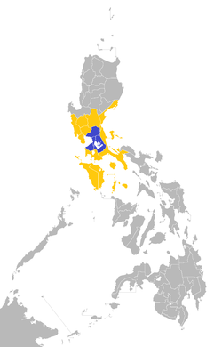
TV ratings agency AGB Nielsen Philippines and Kantar Media Philippines consider Metro Manila and the provinces of Bulacan, Cavite, Laguna and Rizal as "Mega Manila" [4] for their TV ratings gathering (area highlighted in blue on the map), a much stricter definition than the PIA. Using census population in 2010 [5] the area has a population of 25,066,000 or about 26.6% of the population in an area roughly the size of Los Angeles County and average density over 2000 people per square kilometer. As a comparison, only the cities of Tokyo, Jakarta, and Mexico City have reached 25 million people, Shanghai may have but there is not enough detail in suburban statistics on it. Both Mega Manila definitions only include entire provinces, without finer detail.
This Nielsen defined area has a higher ownership of televisions per household anywhere in the country due to its relative economic prosperity as compared to other areas in the country. Radio ratings agency Radio Research Council (provided by KBP) also provide measurement of audience ratings.
The stricter Nielsen definition closer reflects the built-up area surrounding Manila than the PIA definition, Yet even the Nielsen definition of Mega Manila cannot be merely equated to the built-up area; the Nielsen definition includes significant undeveloped forested areas, while completely excluding contiguous developed settlements in such places like northern Batangas. Thus the academic definition as used for urban studies for built-up area surrounding Manila requires yet another term (e.g. Greater Manila Area) to disambiguate from the already used terms Mega Manila and Metro Manila.
Source | Term | NCR | Central Luzon | Calabarzon | Mimaropa | ||||||||||||||
---|---|---|---|---|---|---|---|---|---|---|---|---|---|---|---|---|---|---|---|
AUR | BAN | BUL | NUE | PAM | TAR | ZMB | BTG | CAV | LAG | QUE | RIZ | MAD | PLW | ROM | MDC | MDR | |||
Mega Manila | |||||||||||||||||||
PIA | Mega Manila | ||||||||||||||||||
AGB Nielsen | |||||||||||||||||||
Kantar Media | |||||||||||||||||||
NEDA, JICA | |||||||||||||||||||
Other terms | |||||||||||||||||||
— | Greater Manila Area | ||||||||||||||||||
NEDA, JICA | Greater Capital Region |
Mega Manila encompasses the county's three most populated administrative regions – Calabarzon at number one, followed by Metro Manila, and Central Luzon at third. The total population of Metro Manila and all the 12 provinces, including their three independent cities, 47 component cities, and 238 municipalities, is 41,099,507 as of 2020. This means 38.6 percent of Philippine's total population all live inside Mega Manila. [6]
Region | Provinces | HUC | Ind. cities | Com. cities | Municipalities | Population (2020) |
---|---|---|---|---|---|---|
Metro Manila | — | 16 | — | — | 1 | 13,484,462 |
Central Luzon | Aurora | 0 | 0 | 8 | 235,750 | |
Bataan | 1 | 11 | 853,373 | |||
Bulacan | 3 | 21 | 3,708,890 | |||
Nueva Ecija | 5 | 27 | 2,310,134 | |||
Pampanga | 1 | Angeles City | 2 | 19 | 2,437,709 | |
Tarlac | 0 | 1 | 17 | 1,503,456 | ||
Zambales | 1 | Olongapo | 0 | 13 | 649,615 | |
Calabarzon | Batangas | 0 | 5 | 29 | 2,908,494 | |
Cavite | 7 | 16 | 4,344,829 | |||
Laguna | 6 | 24 | 3,382,193 | |||
Rizal | 1 | 13 | 3,330,143 | |||
Quezon | 1 | Lucena | 0 | 39 | 1,950,459 | |
Total | 12 | 19 | 3 | 47 | 238 | 41,099,507 |
Officially called the National Capital Region, it consists the Philippines' capital city Manila, 15 other cities, and one municipality. It is the seat of government of the Philippines. The cities of Metro Manila are the following:
The continuous region surrounding the Metropolitan Manila area. The provinces and the cities inside Greater Manila Area are the following:
A concept used by urban planners to refer to a region consisting the three regions of Metro Manila, Central Luzon, and Calabarzon. It is used by JICA and NEDA as reference in their planning works. The provinces and cities in the Greater Capital Region are the following:
|
|
Transportation in the Philippines covers the transportation methods within this archipelagic nation of over 7,500 islands. From a previously underdeveloped state of transportation, the government of the Philippines has been improving transportation through various direct infrastructure projects, and these include an increase in air, sea, road, and rail transportation and transport hubs.
Metropolitan Manila, commonly shortened to Metro Manila and formally the National Capital Region, is the capital region and largest metropolitan area of the Philippines. Located on the eastern shore of Manila Bay, the region lies between the Central Luzon and Calabarzon regions. Encompassing an area of 619.57 km2 (239.22 sq mi) and with a population of 13,484,462 as of 2020, it is composed of sixteen highly urbanized cities: the capital city, Manila, Caloocan, Las Piñas, Makati, Malabon, Mandaluyong, Marikina, Muntinlupa, Navotas, Parañaque, Pasay, Pasig, Quezon City, San Juan, Taguig, and Valenzuela, along with one independent municipality, Pateros. As the second most populous and the most densely populated region in the Philippines, it ranks as the 9th most populous metropolitan area in Asia and the 6th most populous urban area in the world.
In the Philippines, regions are administrative divisions that primarily serve to coordinate planning and organize national government services across multiple local government units (LGUs). Most national government offices provide services through their regional branches instead of having direct provincial or city offices. Regional offices are usually but not necessarily located in the city designated as the regional center.
Rizal, officially the Province of Rizal, is a province in the Philippines located in the Calabarzon region in Luzon. Its capital is the city of Antipolo. It is about 16 kilometers (9.9 mi) east of Manila. The province is named after José Rizal, one of the main national heroes of the Philippines. It is bordered by Metro Manila to the west, Bulacan to the north, Quezon to the east and Laguna to the southeast. The province also lies on the northern shores of Laguna de Bay, the largest lake in the country. Rizal is a mountainous province perched on the western slopes of the southern portion of the Sierra Madre mountain range.
Calabarzon, sometimes referred to as Southern Tagalog and designated as Region IV‑A, is an administrative region in the Philippines. The region comprises five provinces: Batangas, Cavite, Laguna, Quezon, and Rizal; and one highly urbanized city, Lucena. It is the most populous region in the Philippines, according to the Philippine Statistics Authority (PSA), having over 16.1 million inhabitants in 2020, and is also the country's second most densely populated after the National Capital Region. It is situated southeast of Metro Manila, and is bordered by Manila Bay and South China Sea to the west, Lamon Bay and the Bicol Region to the east, Tayabas Bay and the Sibuyan Sea to the south, and Central Luzon to the north. It is home to places like Mount Makiling near Los Baños, Laguna, and Taal Volcano in Batangas.
Bulacan, officially the Province of Bulacan, is a province in the Philippines located in the Central Luzon region. Its capital is the city of Malolos. Bulacan was established on August 15, 1578, and part of the Metro Luzon Urban Beltway Super Region.
Southern Tagalog, designated as Region IV, was an administrative region in the Philippines that comprised the current regions of Calabarzon and Mimaropa, the province of Aurora in Central Luzon, and most of the National Capital Region. It was the largest region in the Philippines in terms of both land area and population. After its partition on May 17, 2002, Southern Tagalog continues to exist as a cultural-geographical region.
The Greater Manila Area is the contiguous urbanization region surrounding the Metropolitan Manila area. This built-up zone includes Metro Manila and the neighboring provinces of Bulacan to the north, Cavite and Laguna to the south, and Rizal to the east. Though sprawl continues to absorb new zones, some urban zones are independent clusters of settlements surrounded by non-urban areas.
Noveleta, officially the Municipality of Noveleta, formerly known as Tierra Alta during the Spanish colonial era, is a 3rd class municipality in the province of Cavite, Philippines. According to the 2020 census, it has a population of 49,452 people.
Urban Luzon is the term used for the cities in Southern Luzon.
The Cavite–Laguna Expressway, signed as E3 of the Philippine expressway network, is a partially operational controlled-access toll expressway in the provinces of Cavite and Laguna, Philippines. The construction of the 44.63-kilometer-long (27.73 mi) expressway, which began in June 2017, costs an estimated ₱35.43 billion. Once completed, it will connect the Manila–Cavite Expressway in Kawit to the South Luzon Expressway in Biñan and is expected to ease the traffic congestion in the Cavite–Laguna area, particularly along the Aguinaldo Highway, Governor's Drive, and the Santa Rosa–Tagaytay Road.
The Lingayen–Lucena corridor is the part of Luzon in the Philippines, between Lingayen to Lucena, comprising the province of Pangasinan, and the regions of Central Luzon, Metro Manila, and Calabarzon, where national elections are claimed to be won. The corridor comprises about 40% of the vote.
The Metro Manila Dream Plan, formally titled the Roadmap for Transport Infrastructure Development for Metro Manila and Its Surrounding Areas, refers to a 2014 integrated plan for improving the transport system in Metro Manila, Philippines, with the hope of turning it into a focal point for addressing Metro Manila's interlinked problems in the areas of transportation, land use, and environment.
The Metro Manila Subway, formerly known as the Mega Manila Subway (MMS), is an under-construction underground rapid transit line in Metro Manila, Philippines. The 33-kilometer (21 mi) line, which will run north–south between Valenzuela, Quezon City, Pasig, Taguig, Parañaque and Pasay, consists of 17 stations between the East Valenzuela and Bicutan stations. It will become the country's second direct airport rail link after the North–South Commuter Railway, with a branch line to Ninoy Aquino International Airport.
The Southeast Metro Manila Expressway (SEMME), also known as Skyway Stage 4, C-6 Expressway and formerly as Metro Manila Expressway, is an on-hold 32.664-kilometer (20.296 mi) tolled expressway running across eastern Metro Manila and western Rizal. The expressway will help decongest the existing roadways across Metro Manila, such as EDSA and Circumferential Road 5. The expressway is part of the larger Circumferential Road 6 project. Which it's expansion from original C-6 length currently passing from General Santos Avenue in Taguig up to Highway 2000 in Taytay, will expand to Cainta, Marikina, San Mateo, and in Quezon City.
The enhanced community quarantine in Luzon was a series of stay-at-home orders and cordon sanitaire measures implemented by the Inter-Agency Task Force for the Management of Emerging Infectious Diseases (IATF-EID) on the island of Luzon and its associated islands. It is part of the COVID-19 community quarantines in the Philippines, a larger scale of COVID-19 containment measures with varying degrees of strictness. The "enhanced community quarantine" (ECQ) is the strictest of these measures and is effectively a total lockdown.
COVID-19 community quarantines in the Philippines were a series of stay-at-home orders and cordon sanitaire measures that were implemented by the government of the Philippines through its Inter-Agency Task Force for the Management of Emerging Infectious Diseases (IATF-EID).
The COVID-19 pandemic in Calabarzon is part of the worldwide pandemic of coronavirus disease 2019 caused by severe acute respiratory syndrome coronavirus 2. The virus reached Calabarzon on March 7, 2020, when the first case of the disease was confirmed in Rizal. All provinces in the region has confirmed cases. As of May 2, 2023, the region has 731,358 confirmed cases, with 6,724 deaths.
The Mega Manila Information Office (MMIO) was created pursuant to PIA Order No. 6, series of 2004, consolidating the information services and delivery in the National Capital Region, Region 3 (Central Luzon) and Region 4A (CALABARZON) and 4B (MIMAROPA) and in adherence to the Agency's special order no. 341 rationalizing the regional organizational functions and structure of the Philippine Information Agency.