Geography of Manila

Last updated

The geography of the City of Manila is characterized by its coastal position at the estuary of the Pasig River that flows to Manila Bay. The city is located on a naturally protected harbor, regarded as one of the finest harbors in Asia. [1] The scarce availability of land is a contributing factor that makes Manila the densest populated city in the world.

Contents

Almost all of the city sits atop of centuries of prehistoric alluvial deposits built up by the Pasig River and on some land reclaimed from Manila Bay. The city's land has been altered substantially by human intervention, with considerable land reclamation along the waterfronts since the American colonial times. Some of the natural variations in topography have been evened out due to the urbanization of the city. Manila lies 800 miles (1,300 km) from mainland Asia. [2]

Before and during the Spanish colonization of the Philippines, Manila was the provincial capital over a province whose territory at one time covered nearly all of Luzon, and included the modern territorial subdivisions of Pampanga, Bulacan, Rizal, Laguna, Batangas, Quezon, Mindoro, Masbate and Marinduque. Later, these subdivisions were themselves made provinces, leaving Manila province with a territory roughly equal to the present City of Manila proper (except Intramuros, the capital site), and the northwestern two-thirds of Rizal province. The boundary of Manila province went from northeast to southwest, including Antipolo, Cainta, Taytay and Taguig, and all of the towns north and west of them, in Manila province; and Angono, Teresa, Morong, and the towns south and east of them, in Laguna province. Early in the province's history, the provincial name was changed from Manila to Tondo Province, by which it was known for most of the Spanish era.

In about 1853, four pueblos or towns of Tondo Province were joined with the northeastern towns of Laguna province to form the politico-military Distrito de los Montes de San Mateo, or District of the San Mateo Mountains. The Tondo Province annexed to this new district the towns of Cainta, Taytay, Antipolo and Boso-boso, while Laguna contributed the towns of Angono, Binangonan, Cardona, Morong, Baras, Tanay, Pililla and Jalajala. But the name of the new district proved unwieldy, too long, and misled many into thinking the town of San Mateo (in Tondo province) was the capital of the San Mateo Mountain District, when in reality the district capital was in Morong. So, in 1859, following common practice of the day, the district was renamed after its capital; namely, Morong District. At about the same time, Tondo Province was renamed Manila Province.

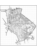
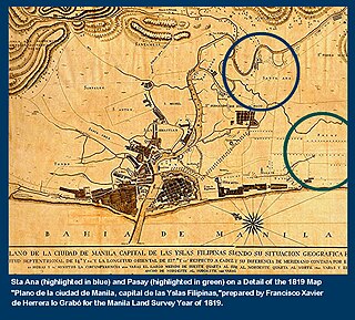
When the Spaniards turned over the Philippines to the hands of the Americans, a civil government was formed. In about the same period, the Manila Province was dissolved by the Philippine Commission, and its pueblos were incorporated with those of the District of Morong, forming the new Province of Rizal. A few weeks, a new charter for the City of Manila, defining its boundaries and annexing some of towns of the Province of Rizal to its districts. These boundaries were slightly revised and redefined on January 29, 1902, when the suburb of Gagalangin was annexed to the city district of Tondo, and the former pueblo of Santa Ana was turned into a city district of Manila. On July 30 of the same year, the city board officially divided the city into 13 political subdivisions named as districts, and the boundaries of each were defined. On August 15 of the same year, the pueblo of Pandacan was annexed as a city district. Since then the boundaries and city districts of Manila have remained essentially the same.

During World War II, the city of Manila was declared an open city and its administrative boundaries expanded to outlying cities and municipalities. It was called the Greater Manila and included districts such as Bagumbayan means New Town (South of Manila), Bagumpanahon means "New Era" (Sampaloc, Quiapo, San Miguel and Santa Cruz), Bagumbuhay means "New Life" (Tondo), Bagong Diwa means "New Order" (Binondo & San Nicholas), the then newly established Quezon City was collapsed and divided into two districts, while the municipalities of Caloocan, Las Piñas, Malabon, Makati, Mandaluyong, Navotas, Parañaque, Pasay, and San Juan became districts of Manila.

Rivers and canals

Pasig River

Pasig River is the main river that bisects the city into the north and south. It flows east to west, and it connects Laguna de Bay to Manila Bay.

San Juan River

San Juan River flows through the northeastern most part of the city at the district of Santa Mesa. It serves as the natural boundary between Manila and the cities of San Juan and Mandaluyong. It is a major tributary of the Pasig River.

City Plan

See also

Related Research Articles

<span class="mw-page-title-main">Rizal (province)</span> Province in Calabarzon, Philippines

Rizal, officially the Province of Rizal, is a province in the Philippines located in the Calabarzon region in Luzon. Its capital is the city of Antipolo. It is about 16 kilometres (9.9 mi) east of Manila. The province is named after José Rizal, one of the main national heroes of the Philippines. It is bordered by Metro Manila to the west, Bulacan to the north, Quezon to the east and Laguna to the southeast. The province also lies on the northern shores of Laguna de Bay, the largest lake in the country. Rizal is a mountainous province perched on the western slopes of the southern portion of the Sierra Madre mountain range.

<span class="mw-page-title-main">Pasig</span> Highly urbanized city in Metro Manila, Philippines

Pasig, officially the City of Pasig, is a highly urbanized city in the National Capital Region of the Philippines. According to the 2020 census, it has a population of 803,159 people.

<span class="mw-page-title-main">Antipolo</span> Capital of Rizal, Philippines

Antipolo, officially the City of Antipolo, is a 1st class component city and capital of the province of Rizal, Philippines. According to the 2020 census, it has a population of 887,399 people. It is the most populous city in the Calabarzon region, and the seventh most-populous city in the Philippines.

<span class="mw-page-title-main">Cainta</span> Municipality in Rizal, Philippines

Cainta, officially the Municipality of Cainta, is a 1st class municipality in the province of Rizal, Philippines. According to the 2020 census, it has a population of 376,933 people.

<span class="mw-page-title-main">Taytay, Rizal</span> Municipality in Rizal, Philippines

Taytay, officially the Municipality of Taytay, is a 1st class municipality in the province of Rizal, Philippines. It is also known as the Garments Capital of the Philippines. Most occupation of the residents are related to supplying different types of garments related things like blouses, pants, dresses and the garment itself at a very low cost. According to the 2020 census, it has a population of 386,451 people. It is the 2nd most populous municipality in the country, after Rodriguez, Rizal.

<span class="mw-page-title-main">Morong, Rizal</span> Municipality in Rizal, Philippines

Morong, officially the Municipality of Morong, is a 2nd class municipality located in the province of Rizal, Philippines. As per the 2020 census, Morong has a population of 71,151 people.

<span class="mw-page-title-main">University of Rizal System</span> System of colleges located in Rizal, Philippines

The University of Rizal System (URS) is a network of colleges located in the Rizal province, Philippines. It operates multiple campuses, with the main campus being in Tanay, Rizal.

<span class="mw-page-title-main">Namayan</span>

Namayan, also called Sapa, Maysapan or Nasapan, and sometimes Lamayan, was an independent indigenous polity on the banks of the Pasig River in the Philippines. It is believed to have achieved its peak in 1175, and to have gone into decline some time in the 13th century, although it continued to be inhabited until the arrival of European colonizers in the 1570s.

<span class="mw-page-title-main">Manila (province)</span> Philippine province (1571–1901)

Manila, also formerly known as Tondo until 1859, was a province in the Philippines, encompassing the former pre-Hispanic polities of Tondo, Maynila and Namayan. In 1898, it included the City of Manila and 23 other municipalities. Alongside the District of Morong, it was incorporated into the Province of Rizal in 1901.

<span class="mw-page-title-main">Ortigas Avenue</span> Major Metro Manila-Rizal arterial

Ortigas Avenue is a 12.1 km (7.5 mi) highway running from eastern Metro Manila to western Rizal in the Philippines. It is one of the busiest highways in Metro Manila, serving as the main thoroughfare of the metro's east–west corridor, catering mainly to the traffic to and from Rizal.

Eastern Metropolitan Bus Corporation or EMBC is one of the largest bus companies in the Philippines. The city operation plies routes from Antipolo, Rizal to Divisoria, Manila via Shaw Boulevard Ortigas Avenue. This bus company also offers tourist chartered and shuttle services.

<span class="mw-page-title-main">Manila East Road</span> Road in the Philippines

The Manila East Road, also known as National Road and National Highway, is a two-to-four lane primary and secondary highway connecting Metro Manila to the provinces of Rizal and Laguna in the Philippines.

<span class="mw-page-title-main">Upper Marikina River Basin Protected Landscape</span>

The Upper Marikina River Basin Protected Landscape is a protected area in the Province of Rizal in the Philippines, which forms the upper area of the drainage basin of the Marikina River.

<span class="mw-page-title-main">2013 Rizal local elections</span>

Local elections were held in Rizal on May 13, 2013, as part of the 2013 general election. Voters will select candidates for all local positions: a municipal/city mayor, vice mayor and town councilors, as well as members of the Sangguniang Panlalawigan, the vice-governor, governor and representatives for the two districts of Rizal.

<span class="mw-page-title-main">Morong (district)</span> Former administrative division of the Philippines

Morong was an administrative division of the Philippines existing as a politico-military district created out of parts of the provinces of Tondo and Laguna on February 23, 1853 by a decree of the Superior Gobierno, composing Morong, Pililla, Tanay, Baras, Binangonan, Jalajala, Angono and Cardona from Laguna; and Antipolo, Boso-Boso, Cainta and Taytay from Tondo. The offices were housed at a building now known as Comandancia. Its first military governor was Francisco Turrentigue.

<span class="mw-page-title-main">Outline of Metro Manila</span> Overview of and topical guide to Metro Manila

The following outline is provided as an overview of and topical guide to Metro Manila:

<span class="mw-page-title-main">Radial Road 5</span>

Radial Road 5, more commonly referred to as R-5, is a network of roads and bridges that all together form the fifth radial road of Manila in the Philippines. The road links the City of Manila with Mandaluyong and Pasig in the east, leading out of Metro Manila into the province of Rizal and south towards Laguna. It is the only arterial road traversing the east side of Laguna de Bay.

<span class="mw-page-title-main">Index of Metro Manila–related articles</span>

The following is an alphabetical list of articles related to the Philippine capital region of Metro Manila.

<span class="mw-page-title-main">2016 Rizal local elections</span>

Local elections will be held in the Province of Rizal on May 9, 2016 as part of the 2016 general election. Voters will select candidates for all local positions: a municipal/city mayor, vice mayor and town councilors, as well as members of the Sangguniang Panlalawigan, the governor, vice-governor and representatives for the two districts of Rizal.

<span class="mw-page-title-main">2019 Rizal local elections</span>

Local elections will be held in the Province of Rizal on May 13, 2019 as part of the 2019 general election. Voters will select candidates for all local positions: a municipal/city mayor, vice mayor and town councilors, as well as members of the Sangguniang Panlalawigan, the governor, vice-governor and representatives for the two districts of Rizal.

References

  1. "Environment — Manila". City-Data. Retrieved February 26, 2017.
  2. "Geography of Manila". HowStuffWorks . Retrieved 2010-04-13.