Marikina Valley Fault System

Last updated • 2 min readFrom Wikipedia, The Free Encyclopedia

Marikina Valley Fault System
Fault Plane of WVFS at Barangay Mabuhay Carmona (cropped).jpg
Lower and upper fault plain along the West Valley Fault in Carmona, Cavite
Relief Map of Metro Manila and nearby provinces showing the West and East Valley Fault Line (cropped).jpg
Map of the Marikina Valley Fault System
showing relative motion and deformation
Etymology Marikina
Named by Philippine Institute of Volcanology and Seismology
Year defined2010
Coordinates 14°38′N121°5′E / 14.633°N 121.083°E / 14.633; 121.083
Country Philippines
Region Central Luzon, Metro Manila, Calabarzon
CitiesWest: Marikina, Quezon City, Pasig, Taguig, Muntinlupa, General Mariano Alvarez, Carmona, Silang, San Pedro, Biñan, Santa Rosa, Cabuyao, Calamba
East: Rodriguez, San Mateo
Characteristics
SegmentsWest Valley Fault, East Valley Fault
Length146 km (91 mi) [1]
Displacement 10–12 mm (0.39–0.47 in)/yr
Tectonics
Plate Philippine Sea Plate and Sunda Plate
Status Active
Earthquakes 1658[ citation needed ], 1771[ citation needed ]
Type Strike-slip fault
Movement Dextral
Age Gelasian
Orogeny Luzon-Mindoro-Palawan Orogeny
Volcanic arc/belt Macolod Corridor

The Marikina Valley Fault System, also known as the Valley Fault System (VFS), is a dominantly right-lateral strike-slip fault system in Luzon, Philippines. [2] It extends from Doña Remedios Trinidad, Bulacan in the north, running through the provinces of Rizal, the Metro Manila cities of Quezon, Marikina, Pasig, Taguig and Muntinlupa, and the provinces of Cavite and Laguna, before ending in Canlubang in the south. [1]

Contents

Fault segments

Relief map of Metro Manila and nearby provinces showing the surface traces of the West and East Valley Faults Relief Map of Metro Manila and nearby provinces showing the West and East Valley Fault Line.jpg
Relief map of Metro Manila and nearby provinces showing the surface traces of the West and East Valley Faults

The fault contains two major segments: the West Valley Fault (WVF) and the East Valley Fault (EVF).

West Valley Fault

The western segment, known as the West Valley Fault (WVF), is one of the two major fault segments of the Valley Fault System, which runs through the cities of Marikina, Quezon City, Pasig, Taguig and Muntinlupa in Metro Manila [1] and moves in a dominantly dextral strike-slip motion. [2] The West Valley Fault segment extends from Doña Remedios Trinidad to Calamba and is 129.47 kilometers (80.45 mi) long. [1]

The West Valley Fault is capable of producing large-scale earthquakes during its active phases with a magnitude of 7 or higher. [3]

East Valley Fault

The eastern segment, known as the East Valley Fault (EVF), moves in an oblique dextral motion. [2] It extends about 17.24 kilometers (10.71 mi) from Rodriguez to San Mateo in the province of Rizal. [1]

Threat

Buildings traversed by the West Valley Fault Line in Pasig with 5-meter buffer zone. doi:10.13140/RG.2.2.31921.07526 West Valley Fault in Pasig.png
Buildings traversed by the West Valley Fault Line in Pasig with 5-meter buffer zone. doi:10.13140/RG.2.2.31921.07526

Based on kinematic block models that utilize GPS, actual fault geometry, and earthquake focal mechanisms, the western segment of the Marikina Valley Fault System was resolved to be almost fully locked, meaning it is currently accumulating and loading elastic strain at a rate of 10 to 12 mm/yr. [4] The fault poses a threat of a large-scale earthquake with an estimated magnitude between 6–7 and as high as 7.6 [5] to Metro Manila and surrounding provinces, with a death toll predicted to be as high as 35,000 [6] [7] and some 120,000 or higher [6] injured [7] and more than three million needed to be evacuated. [3]

There are 99 private villages and subdivisions inside 80 barangays traversed directly by the fault, [8] and it endangers 6,331 buildings in a span of 2,964.10 square kilometers (1,144.45 sq mi), where the majority are houses with 19 schools included in the list. [1]

Related Research Articles

<span class="mw-page-title-main">Metro Manila</span> Metropolitan area and region of the Philippines

Metropolitan Manila, commonly shortened to Metro Manila and formally the National Capital Region, is the capital region and largest metropolitan area of the Philippines. Located on the eastern shore of Manila Bay, the region lies between the Central Luzon and Calabarzon regions. Encompassing an area of 636.00 km2 (245.56 sq mi) and with a population of 13,484,462 as of 2020, it is composed of sixteen highly urbanized cities: the capital city, Manila, Caloocan, Las Piñas, Makati, Malabon, Mandaluyong, Marikina, Muntinlupa, Navotas, Parañaque, Pasay, Pasig, Quezon City, San Juan, Taguig, and Valenzuela, along with one independent municipality, Pateros. As the second most populous and the most densely populated region in the Philippines, it ranks as the 9th most populous metropolitan area in Asia and the 6th most populous urban area in the world.

<span class="mw-page-title-main">Pan-Philippine Highway</span> Highway in the Philippines traversing most of the country

The Pan-Philippine Highway, also known as the Maharlika Highway, is a network of roads, expressways, bridges, and ferry services that connect the islands of Luzon, Samar, Leyte, and Mindanao in the Philippines, serving as the country's principal transport backbone. Measuring 3,379.73 kilometers (2,100.07 mi) long excluding sea routes not counted by highway milestones, it is the longest road in the Philippines that forms the country's north–south backbone component of National Route 1 (N1) of the Philippine highway network. The entire highway is designated as Asian Highway 26 (AH26) of the Asian Highway Network.

<span class="mw-page-title-main">Metro Manila Skyway</span> Elevated expressway in Metro Manila, Philippines

The Metro Manila Skyway, officially the Metro Manila Skyway System (MMSS) or simply the Skyway, is an elevated highway serving as the main expressway of Metro Manila, Philippines. It connects the North and South Luzon Expressways with access to Ninoy Aquino International Airport via the NAIA Expressway (NAIAX). It is the first fully grade-separated highway in the Philippines and one of the longest elevated highways in the world, with a total length of approximately 39.2 kilometers (24.4 mi).

<span class="mw-page-title-main">Marikina River</span> River in Luzon, Philippines

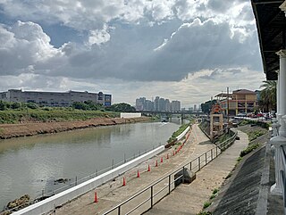
The Marikina River is a river in eastern Metro Manila, Philippines. It is the largest tributary of the Pasig River, with headwaters located in the Sierra Madre Mountains in Rodriguez, Rizal province.

<span class="mw-page-title-main">Marikina–Infanta Highway</span> Major road in the Philippines

The Marikina–Infanta Highway, also known as Marilaque Highway, Marilaque Road, Marikina-Infanta Road, or its former name Marcos Highway, is a 117.5-kilometer (73.0 mi) highway that connects Quezon City, Metro Manila with Infanta, Quezon in the Philippines. Motorists colloquially refer to the road as Marilaque Highway.

<span class="mw-page-title-main">Circumferential Road 5</span> Major road in Metro Manila, Philippines

Circumferential Road 5 (C-5), informally known as the C-5 Road, is a network of roads and bridges which comprise the fifth beltway of Metro Manila in the Philippines. Spanning some 43.87 kilometers (27.26 mi), it connects the cities of Las Piñas, Parañaque, Pasay, Pasig, Quezon City, Taguig, and Valenzuela.

<span class="mw-page-title-main">Radial Road 3</span> Road in the Philippines

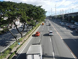
Radial Road 3 (R-3), informally known as the R-3 Road, is a network of roads and bridges that all together form the third arterial road of Metro Manila in the Philippines. It connects the cities of Manila, Makati, Pasay, Taguig, Parañaque, and Muntinlupa.

The Philippine Fault System is a major inter-related system of geological faults throughout the whole of the Philippine Archipelago, primarily caused by tectonic forces compressing the Philippines into what geophysicists call the Philippine Mobile Belt. Some notable Philippine faults include the Guinayangan, Masbate and Leyte faults.

<span class="mw-page-title-main">Outline of Metro Manila</span> Overview of and topical guide to Metro Manila

The following outline is provided as an overview of and topical guide to Metro Manila:

<span class="mw-page-title-main">Index of Metro Manila–related articles</span>

The following is an alphabetical list of articles related to the Philippine capital region of Metro Manila.

The 2017 Surigao earthquake occurred on February 10, 2017, at 10:03 PM (PST), with a surface wave magnitude of 6.7 off the coast of Surigao del Norte in the Philippines. According to the PHIVOLCS Earthquake Intensity Scale the earthquake was an Intensity VII (Destructive) earthquake at maximum. In the past Surigao province has been hit by a magnitude 7.2 tremor in both 1879 and 1893.

<span class="mw-page-title-main">Metro Manila Subway</span> Future Manila metro line

The Metro Manila Subway, formerly known as the Mega Manila Subway (MMS) is an under-construction underground rapid transit line in Metro Manila, Philippines. The 33-kilometer (21 mi) line, which will run north–south between Valenzuela, Quezon City, Pasig, Taguig, Parañaque and Pasay, consists of 17 stations between the East Valenzuela and Bicutan stations. It will become the country's second direct airport rail link after the North–South Commuter Railway, with a branch line to Ninoy Aquino International Airport.

<span class="mw-page-title-main">Southeast Metro Manila Expressway</span> Highway under construction in the Philippines

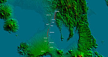
The Southeast Metro Manila Expressway (SEMME), also known as Skyway Stage 4, C-6 Expressway and formerly as Metro Manila Expressway, is an on-hold 32.664-kilometer (20.296 mi) tolled expressway running across eastern Metro Manila and western Rizal. The expressway will help decongest the existing roadways across Metro Manila, such as EDSA and Circumferential Road 5. The expressway is part of the larger Circumferential Road 6 project. Which it's expansion from original C-6 length currently passing from General Santos Avenue in Taguig up to Highway 2000 in Taytay, will expand to Cainta, Pasig, Marikina, San Mateo, and in Quezon City.

On April 22, 2019, at 05:11:09 p.m. (PST), an earthquake with a magnitude of 6.1Mw  struck the island of Luzon in the Philippines, leaving at least 18 dead, three missing and injuring at least 256 others. Despite the fact that the epicenter was in Zambales, most of the damage to infrastructure occurred in the neighboring province of Pampanga, which suffered damage to 29 buildings and structures.

The 1879 Surigao earthquake occurred on June 30 at 18:38 02:55 local time on the northeastern tip of Mindanao. The earthquake with a moment magnitude (Mw ) of 7.4 struck with an epicenter just south of Lake Mainit. Extensive damage occurred but there were no reports of casualties.

<span class="mw-page-title-main">2022 Luzon earthquake</span> Earthquake in the Philippines

On July 27, 2022, at 8:43:24 a.m. (PHT), an earthquake struck the island of Luzon in the Philippines. The earthquake had a magnitude of 7.0 Mw , with an epicenter in Abra province. Eleven people were reported dead and 615 were injured. At least 35,798 homes, schools and other buildings were damaged or destroyed, resulting in ₱1.88 billion (US$34 million) worth of damage.

References

  1. 1 2 3 4 5 6 Malicdem, Ervin (August 16, 2017). "Barangays and Buildings Traversed by the Valley Fault System". Schadow1 Expeditions. Retrieved September 7, 2017. There are about 6,331 structures that are directly above the Valley Fault System within a 10-meter proximity which would be in potential danger of destruction once the slip-fault moves. This sums up to an area of 2,964.10 square kilometers in danger of collapse.
  2. 1 2 3 Rimando, Rolly E.; Knuepfer, Peter L.K. (2004). "Neotectonics of the Marikina Valley fault system (MVFS) and tectonic framework of structures in northern and central Luzon, Philippines". Tectonophysics . 415 (1–4): 17–38. doi:10.1016/j.tecto.2005.11.009.
  3. 1 2 "'Big One' Is Possible But Metro Is Unprepared". Quezon City, Philippines: Bulatlat. August 14, 2004. Retrieved February 3, 2010. If a major earthquake were to hit Metro Manila today, the devastation would be so big even disaster response authorities cannot simply cope with it. And it even looks like disaster preparedness occupies a low priority among officials down to the municipal level.
  4. Galgana, Gerald (2007). "Analysis of crustal deformation in Luzon, Philippines using geodetic observations and earthquake focal mechanisms". Tectonophysics . 432 (1–4): 63–87. Bibcode:2007Tectp.432...63G. doi:10.1016/j.tecto.2006.12.001.
  5. Nelson, Alan R.; Personius, Stephen F.; Rimando, Rolly E.; Punongbayan, Raymundo S.; Tungol, Norman; Mirabueno, Hannah; Rasdas, Ariel (2000). "Multiple Large Earthquakes in the Past 1500 Years on a Fault in Metropolitan Manila, the Philippines". Bulletin of the Seismological Society of America . 90 (1): 84. Bibcode:2000BuSSA..90...73N. doi:10.1785/0119990002.
  6. 1 2 Ubac, Michael (June 20, 2009). "UN to Metro Manila: Ready for Big One?". Inquirer.net . Philippine Daily Inquirer . Retrieved January 30, 2010. Is Metro Manila prepared for the Big One?
  7. 1 2 "Big earthquake in Marikina Valley fault line?". Pinoymoneytalk.com. June 20, 2009. Retrieved January 30, 2010. The United Nations is advising the Philippines to be ready for an upcoming big earthquake. A quake with a magnitude of 7 or higher on the Richter scale is sure to hit Metro Manila, they say, but the bigger question is when exactly this will happen.
  8. Malicdem, Ervin (August 25, 2017). "LIST: 99 Villages and Subdivisions Traversed by the Valley Fault System". Schadow1 Expeditions. Retrieved September 7, 2017.