Mabitac | |
---|---|
Municipality of Mabitac | |
Mabitac Poblacion | |
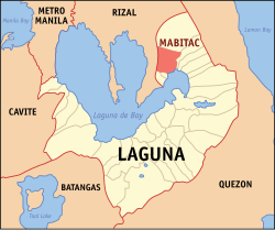
![]() Map of Laguna with Mabitac highlighted | |
Location within the Philippines | |
Coordinates: 14°26′N121°25′E / 14.43°N 121.42°E | |
Country | Philippines |
Region | Calabarzon |
Province | Laguna |
District | 4th district |
Founded | January 6, 1616 |
Barangays | 15 (see Barangays) |
Government | |
• Type | Sangguniang Bayan |
• Mayor | Alberto S. Reyes |
• Vice Mayor | Ronald I. Sana |
• Representative | Benjamin Cueto "Benjie" Agarao Jr. |
• Municipal Council | Members |
• Electorate | 14,935 voters (2025) |
Area | |
• Total | 80.76 km2 (31.18 sq mi) |
Elevation | 128 m (420 ft) |
Highest elevation | 726 m (2,382 ft) |
Lowest elevation | −1 m (−3 ft) |
Population (2024 census) [3] | |
• Total | 21,748 |
• Density | 270/km2 (700/sq mi) |
• Households | 5,022 |
Economy | |
• Income class | 5th municipal income class |
• Poverty incidence | 9.79 |
• Revenue | ₱ 139 million (2022) |
• Assets | ₱ 280.9 million (2022) |
• Expenditure | ₱ 115.8 million (2022) |
• Liabilities | ₱ 79.29 million (2022) |
Service provider | |
• Electricity | First Laguna Electric Cooperative (FLECO) |
Time zone | UTC+8 (PST) |
ZIP code | 4020 |
PSGC | |
IDD : area code | +63 (0)49 |
Native languages | Tagalog |
Website | www |
Mabitac, officially the Municipality of Mabitac (Tagalog : Bayan ng Mabitac), is a municipality in the province of Laguna, Philippines. According to the 2020 census, it has a population of 21,275 people. [5]
Mabitac was an excellent hunting ground for wild game three centuries ago. Native hunters used numerous cave-ins or trap-ins called "bitag" in the local dialect. Hence, the place was referred to as "Mabitag" meaning "a place with many traps".
Mabitac is 30 kilometres (19 mi) from Santa Cruz, 76 kilometres (47 mi) from Manila, and 59 kilometres (37 mi) from Antipolo.
The first Spaniards who came to this place were the friars who established the first Spanish settlement in the area and began to Christianize the local population. The Spaniards, having difficulty in pronouncing the "G" consonant, called this place "Mabitac" whenever they mentioned this place. Eventually, the name found its way in the official records and maps of Laguna made by Spanish cartographers and mariners who chartered the coastal areas of Laguna de Bay.
This town was formerly a barrio of Siniloan, an immediate neighboring town. It became an independent municipality only in the year 1611, not by legislation, but by mutual agreement by and between the Spanish friars of both towns who were then the influential ruling class.
Mabitac was the site of a battle in the Philippine–American War, when on September 17, 1900, Filipinos under General Juan Cailles defeated an American force commanded by Colonel Benjamin F. Cheatham.
The Japanese occupation of the Philippines occurred between 1942 and 1945, when Imperial Japan occupied the Commonwealth of the Philippines during World War II. The invasion of the Philippines started on 8 December 1941, ten hours after the attack on Pearl Harbor.
In 1942, Japanese soldiers entered and occupied Mabitac. In 1945, the Philippine guerrillas and irregular forces defeated the Japanese Imperial forces and liberated Mabitac.
Mabitac is politically subdivided into 15 barangays, as indicated below: [6] Each barangay consists of puroks and some have sitios.
Climate data for Mabitac, Laguna | |||||||||||||
---|---|---|---|---|---|---|---|---|---|---|---|---|---|
Month | Jan | Feb | Mar | Apr | May | Jun | Jul | Aug | Sep | Oct | Nov | Dec | Year |
Mean daily maximum °C (°F) | 26 (79) | 27 (81) | 29 (84) | 31 (88) | 31 (88) | 30 (86) | 29 (84) | 29 (84) | 29 (84) | 29 (84) | 28 (82) | 26 (79) | 29 (84) |
Mean daily minimum °C (°F) | 22 (72) | 22 (72) | 22 (72) | 23 (73) | 24 (75) | 25 (77) | 24 (75) | 24 (75) | 24 (75) | 24 (75) | 24 (75) | 23 (73) | 23 (74) |
Average precipitation mm (inches) | 58 (2.3) | 41 (1.6) | 32 (1.3) | 29 (1.1) | 91 (3.6) | 143 (5.6) | 181 (7.1) | 162 (6.4) | 172 (6.8) | 164 (6.5) | 113 (4.4) | 121 (4.8) | 1,307 (51.5) |
Average rainy days | 13.4 | 9.3 | 9.1 | 9.8 | 19.1 | 22.9 | 26.6 | 24.9 | 25.0 | 21.4 | 16.5 | 16.5 | 214.5 |
Source: Meteoblue [7] |
Year | Pop. | ±% p.a. |
---|---|---|
1903 | 1,052 | — |
1918 | 760 | −2.14% |
1939 | 1,973 | +4.65% |
1948 | 2,700 | +3.55% |
1960 | 4,316 | +3.99% |
1970 | 6,377 | +3.98% |
1975 | 7,415 | +3.07% |
1980 | 8,543 | +2.87% |
1990 | 11,444 | +2.97% |
1995 | 13,309 | +2.87% |
2000 | 15,097 | +2.74% |
2007 | 17,608 | +2.14% |
2010 | 18,618 | +2.05% |
2015 | 20,530 | +1.88% |
2020 | 21,275 | +0.75% |
2024 | 21,748 | +0.53% |
Source: Philippine Statistics Authority [8] [9] [10] [11] [12] |
In the 2020 census, the population of Mabitac was 21,275 people, [13] with a density of 260 inhabitants per square kilometre or 670 inhabitants per square mile.
Poverty incidence of Mabitac
10 20 30 40 2000 35.68 2003 24.42 2006 11.40 2009 14.43 2012 22.49 2015 16.91 2018 2.99 2021 9.79 Source: Philippine Statistics Authority [14] [15] [16] [17] [18] [19] [20] [21] |