Taysan | |
|---|---|
| Municipality of Taysan | |
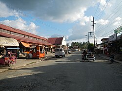 Downtown | |
 Seal | |
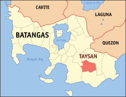 Map of Batangas with Taysan highlighted | |
OpenStreetMap  | |
 Taysan Location within the Philippines | |
| Coordinates: 13°47′N121°12′E / 13.78°N 121.2°E | |
| Country | Philippines |
| Region | Calabarzon |
| Province | Batangas |
| District | 4th district |
| Founded/Chartered | 1919 |
| Barangays | 20 (see Barangays) |
| Government | |
| • Type | Sangguniang Bayan |
| • Mayor | Brigido A. Villena |
| • Vice Mayor | Eloisa Angela D. Portugal |
| • Representative | Amado Carlos A. Bolilia IV |
| • Municipal Council | Members |
| • Electorate | 30,000 voters (2025) |
| Area | |
• Total | 93.62 km2 (36.15 sq mi) |
| Elevation | 196 m (643 ft) |
| Highest elevation | 977 m (3,205 ft) |
| Lowest elevation | 31 m (102 ft) |
| Population (2024 census) [3] | |
• Total | 41,332 |
| • Density | 441.5/km2 (1,143/sq mi) |
| • Households | 9,735 |
| Economy | |
| • Income class | 2nd municipal income class |
| • Poverty incidence | 6.38 |
| • Revenue | ₱ 238.8 million (2022) |
| • Assets | ₱ 627.6 million (2022) |
| • Expenditure | ₱ 229.7 million (2022) |
| • Liabilities | ₱ 214.5 million (2022) |
| Service provider | |
| • Electricity | Batangas 2 Electric Cooperative (BATELEC 2) |
| Time zone | UTC+8 (PST) |
| ZIP code | 4228 |
| PSGC | |
| IDD : area code | +63 (0)43 |
| Native languages | Tagalog |
Taysan, officially the Municipality of Taysan (Tagalog : Bayan ng Taysan), is a municipality in the province of Batangas, Philippines. According to the 2020 census, it has a population of 40,146 people. [5]
Contents
- Etymology
- History
- Geography
- Barangays
- Climate
- Demographics
- Economy
- Education
- Primary and elementary schools
- Secondary schools
- Gallery
- References
- External links
It is known for its array of specialty street foods, particularly those served on skewers. Among the popular offerings are barbeque, bananacue, corn, kwek-kwek, hotdog, and grilled milkfish, which have become local favorites and a staple of the town’s culinary culture. [6] [7]


