San Pascual, Batangas

Last updated
San Pascual
Municipality of San Pascual
Municipal Hall of San Pascual, Batangas.jpg
4San Pascual, Batangas Landmarks 16.jpg
SanPascual,BatangasChurchjf9141 12.JPG
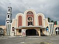
From top to bottom: San Pascual Municipal Hall, Downtown San Pascual, San Pascual Baylon Parish Church
FLAG OF SAN PASCUAL.jpg
SAN PASCUAL SEAL.png
Motto(s): 
"San Pascual, Bayan Nating Mahal"
"San Pascual, Bayang Marangal"
Ph locator batangas san pascual.png
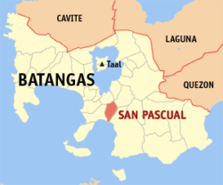
Map of Batangas with San Pascual highlighted
OpenStreetMap
San Pascual, Batangas
Philippines location map (square).svg
Red pog.svg
San Pascual
Location within the Philippines
Coordinates: 13°48′N121°02′E / 13.8°N 121.03°E / 13.8; 121.03
Country Philippines
Region Calabarzon
Province Batangas
District 2nd district
Founded August 4, 1969 [1]
Named for St. Paschal Baylón
Barangays 29 (see Barangays)
Government
[2]
  Type Sangguniang Bayan
   Mayor Antonio A. Dimayuga
   Vice Mayor Angelina D. Castillo
   Representative Gerville Luistro
   Municipal Council
Members
   Electorate 41,762 voters (2022)
Area
[3]
  Total50.70 km2 (19.58 sq mi)
Elevation
46 m (151 ft)
Highest elevation
155 m (509 ft)
Lowest elevation
0 m (0 ft)
Population
 (2020 census) [4]
  Total69,009
  Density1,400/km2 (3,500/sq mi)
   Households
17,717
Economy
   Income class 1st municipal income class
   Poverty incidence
7.53
% (2018) [5]
   Revenue 308.9 million (2020)
   Assets 863.9 million (2020)
   Expenditure 238.2 million (2020)
   Liabilities 85.09 million (2020)
Service provider
  ElectricityManila Electric Company (Meralco)
Time zone UTC+8 (PST)
ZIP code
4204
PSGC
IDD : area code +63(0)43
Native languages Tagalog
Major religions Christianity
Patron saint St. Paschal Baylón

San Pascual, officially the Municipality of San Pascual (Tagalog : Bayan ng San Pascual), is a 1st class municipality in the province of Batangas, Philippines. According to the 2020 census, it has a population of 69,009 making it as the 9th most populous municipality in the province.

Contents

The municipality borders Bauan on the west, Alitagtag and San Jose on the north, and Batangas City on the east.

History

Border between Batangas City and San Pascual. 4San Pascual, Batangas Landmarks 12.jpg
Border between Batangas City and San Pascual.

Separation from Bauan

Historically, San Pascual was a part of Bauan and was referred to as "Lagnas." San Pascual became a separate municipality in 1969 due to Mayor Leonardo "Leoning" Mendoza's tenacious leadership. The name "Lagnas", which refers to the municipality's location physically between the Lagnas and Hagonoy Rivers, is derived from the local dialect and means "river boundaries."

Religious attributions

The religious populace and congregation therefore changed the name of the Lagnas neighborhood to San Pascual De Baylon in honor of the Roman Catholic saint. It was thought that naming a location after one of its patron saints would bring luck and a prosperous future. As a result, somewhere around 1959, the San Pascual neighborhood became the Parish of San Pascual de Baylon, with the aforementioned saint serving as its Patron Saint.

Government

Local government

The municipal mayor is in charge of the municipality and serves as the head of the local government. The vice mayor serves as the mayor's deputy. Regarding the local legislature. The Sangguniang Bayan serves as the municipality's local legislature. The vice mayor serves as its president, and the council is made up of eight "councillors."

Representative

2nd district BATANGAS-LEG-2.png
2nd district

San Pascual is in the Batangas's 2nd congressional district. Gerville Luistro (Lakas-CMD) is the current representative of the 2nd district, succeeding Raneo Abu (NP).

Geography

San Pascual is located at 13°48′N121°02′E / 13.8°N 121.03°E / 13.8; 121.03 .

According to the Philippine Statistics Authority, the municipality has a land area of 50.70 square kilometres (19.58 sq mi) [6] constituting

San Pascual is 5 kilometres (3.1 mi) from Batangas City and 110 kilometres (68 mi) from Manila.

Barangays

San Pascual is politically subdivided into 29 barangays. [7] Each barangay consists of puroks and some have sitios.

PSGC Barangay Population ±% p.a.
2020 [4] 2010 [8]
041026001 Alalum 3.1% 2,155 1,986 0.82%
041026002 Antipolo 1.7% 1,176 1,106 0.62%
041026003 Balimbing 2.4% 1,648 522 12.18%
041026004 Banaba 3.9% 2,662 2,440 0.87%
041026005 Bayanan 4.3% 2,939 2,721 0.77%
041026006 Danglayan 1.2% 841 580 3.78%
041026007 Del Pilar 1.1% 759 667 1.30%
041026008 Gelerang Kawayan 2.2% 1,533 1,519 0.09%
041026009 Ilat North 2.2% 1,544 1,416 0.87%
041026010 Ilat South 2.0% 1,363 1,385 −0.16%
041026011 Kaingin 1.6% 1,130 1,022 1.01%
041026012 Laurel 3.1% 2,108 2,045 0.30%
041026013 Malaking Pook 1.1% 780 756 0.31%
041026014 Mataas na Lupa 3.0% 2,092 1,938 0.77%
041026015 Natunuan North 2.3% 1,557 1,474 0.55%
041026016 Natunuan South 1.7% 1,198 1,053 1.30%
041026017 Padre Castillo 1.7% 1,189 960 2.16%
041026018 Palsahingin 1.5% 1,065 980 0.84%
041026019 Pila 1.3% 928 880 0.53%
041026020 Poblacion 14.8% 10,188 9,977 0.21%
041026021 Pook ni Banal 2.0% 1,347 1,223 0.97%
041026022 Pook ni Kapitan 1.3% 927 752 2.11%
041026023 Resplandor 1.7% 1,148 1,058 0.82%
041026024 Sambat 9.0% 6,213 5,633 0.98%
041026025 San Antonio 13.2% 9,096 8,639 0.52%
041026026 San Mariano 3.4% 2,336 2,154 0.81%
041026027 San Mateo 2.4% 1,651 1,201 3.23%
041026028 Santa Elena 0.9% 650 595 0.89%
041026029 Santo Niño 4.6% 3,201 2,916 0.94%
Total69,00959,5981.48%

Climate

Climate data for San Pascual, Batangas
MonthJanFebMarAprMayJunJulAugSepOctNovDecYear
Average high °C (°F)28
(82)
29
(84)
31
(88)
32
(90)
31
(88)
30
(86)
29
(84)
28
(82)
28
(82)
29
(84)
29
(84)
28
(82)
29
(85)
Average low °C (°F)19
(66)
19
(66)
20
(68)
22
(72)
24
(75)
24
(75)
24
(75)
24
(75)
24
(75)
23
(73)
21
(70)
20
(68)
22
(72)
Average precipitation mm (inches)11
(0.4)
13
(0.5)
14
(0.6)
32
(1.3)
101
(4.0)
142
(5.6)
208
(8.2)
187
(7.4)
175
(6.9)
131
(5.2)
68
(2.7)
39
(1.5)
1,121
(44.3)
Average rainy days5.25.07.411.519.823.527.025.925.223.215.58.3197.5
Source: Meteoblue [9]

Demographics

Population census of San Pascual
YearPop.±% p.a.
1970 19,377    
1975 21,761+2.35%
1980 26,221+3.80%
1990 34,629+2.82%
1995 40,849+3.14%
2000 49,041+4.00%
2007 57,200+2.15%
2010 59,598+1.51%
2015 65,424+1.79%
2020 69,009+1.05%
Source: Philippine Statistics Authority [10] [8] [11] [12]

In the 2020 census, San Pascual had a population of 69,009. [4] The population density was 1,400 inhabitants per square kilometre (3,600/sq mi).

Economy

As one of the towns adjacent to the province's capital, it is a bustling town full of businesses and establishments.

The town is home to an oil refinery, chemical plants and various subdivisions and housing projects, as well as other industrial and commercial establishments.

Hospitals

Education

There are numerous elementary and high schools, offering primary and secondary education in the town of San Pascual. The most known high school in the municipality is the San Pascual National High School.

Related Research Articles

<span class="mw-page-title-main">Mabini, Batangas</span> Municipality in Batangas, Philippines

Mabini, officially the Municipality of Mabini, is a 1st class municipality in the province of Batangas, Philippines. According to the 2020 census, it has a population of 50,858 people.

<span class="mw-page-title-main">Alaminos, Laguna</span> Municipality in Laguna, Philippines

Alaminos, officially the Municipality of Alaminos, is a 3rd class municipality in the province of Laguna, Philippines. According to the 2020 census, it has a population of 51,619 people.

<span class="mw-page-title-main">Talisay, Batangas</span> Municipality in Batangas, Philippines

Talisay, officially the Municipality of Talisay, is a 3rd class municipality in the province of Batangas, Philippines. According to the 2020 census, it has a population of 46,238 people.

<span class="mw-page-title-main">San Jose, Batangas</span> Municipality in Batangas, Philippines

San Jose, officially the Municipality of San Jose, is a 1st class municipality in the province of Batangas, Philippines. According to the 2020 census, it has a population of 79,868 people.

<span class="mw-page-title-main">Agoncillo, Batangas</span> Municipality in Batangas, Philippines

Agoncillo, officially the Municipality of Agoncillo, is a 4th class municipality in the province of Batangas, Philippines. According to the 2020 census, it has a population of 39,101 people.

<span class="mw-page-title-main">Alitagtag</span> Municipality in Batangas, Philippines

Alitagtag, officially the Municipality of Alitagtag, is a 4th class municipality in the province of Batangas, Philippines. According to the 2020 census, it has a population of 26,819 people.

<span class="mw-page-title-main">Balete, Batangas</span> Municipality in Batangas, Philippines

Balete, officially the Municipality of Balete, is a 5th class municipality in the province of Batangas, Philippines. According to the 2020 census, it has a population of 24,055 people. The people from Balete is called Baleteños.

<span class="mw-page-title-main">Bauan</span> Municipality in Batangas, Philippines

Bauan, officially the Municipality of Bauan, is a 1st class municipality in the province of Batangas, Philippines. According to the 2020 census, it has a population of 90,819 people.

<span class="mw-page-title-main">Calaca, Batangas</span> Component city in Batangas, Philippines

Calaca, officially the City of Calaca, is a component city in the province of Batangas, Philippines. According to the 2020 census, it has a population of 87,361 people.

<span class="mw-page-title-main">Cuenca, Batangas</span> Municipality in Batangas, Philippines

Cuenca, officially the Municipality of Cuenca, is a 4th class municipality in the province of Batangas, Philippines. According to the 2020 census, it has a population of 36,235 people.

<span class="mw-page-title-main">Laurel, Batangas</span> Municipality in Batangas, Philippines

Laurel, officially the Municipality of Laurel, is a 3rd class municipality in the province of Batangas, Philippines. According to the 2022 census, it has a population of 46,612 people.

<span class="mw-page-title-main">Lian, Batangas</span> Municipality in Batangas, Philippines

Lian, officially the Municipality of Lian, is a 3rd class municipality in the province of Batangas, Philippines. According to the 2020 census, it has a population of 56,280 people.

<span class="mw-page-title-main">Lobo, Batangas</span> Municipality in Batangas, Philippines

Lobo, officially the Municipality of Lobo, is a 3rd class municipality in the province of Batangas, Philippines. According to the 2020 census, it has a population of 40,736 people.

<span class="mw-page-title-main">Padre Garcia</span> Municipality in Batangas, Philippines

Padre Garcia, officially the Municipality of Padre Garcia, is a 2nd class municipality in the province of Batangas, Philippines. According to the 2020 census, it has a population of 51,853 people.

<span class="mw-page-title-main">San Luis, Batangas</span> Municipality in Batangas, Philippines

San Luis, officially the Municipality of San Luis, is a 4th class municipality in the province of Batangas, Philippines. According to the 2020 census, it has a population of 36,172 people.

<span class="mw-page-title-main">San Nicolas, Batangas</span> Municipality in Batangas, Philippines

San Nicolas, officially the Municipality of San Nicolas, is a 5th class municipality in the province of Batangas, Philippines. According to the 2020 census, it has a population of 23,908 people. It is equivalent to 0.15 percent of the population in the Calabarzon area or 0.82% of the total population of Batangas province. These numbers are used to calculate the population density, which is 1,057 inhabitants per square kilometer or 2,740 inhabitants per square mile. The municipality makes up 0.73% of Batangas's total area, with a land area of 22.61 square kilometers or 8.73 square miles. It is equivalent to 0.15 percent of the population in the Calabarzon area or 0.82% of the total population of Batangas province.

<span class="mw-page-title-main">Santa Teresita, Batangas</span> Municipality in Batangas, Philippines

Santa Teresita, officially the Municipality of Santa Teresita, is a 5th class municipality in the province of Batangas, Philippines. According to the 2020 census, it has a population of 21,559 people.

<span class="mw-page-title-main">Taysan</span> Municipality in Batangas, Philippines

Taysan, officially the Municipality of Taysan, is a 2nd class municipality in the province of Batangas, Philippines. According to the 2020 census, it has a population of 40,146 people.

<span class="mw-page-title-main">Tingloy</span> Municipality in Batangas, Philippines

Tingloy, officially the Municipality of Tingloy, is a 5th class municipality in the province of Batangas, Philippines. According to the 2020 census, it has a population of 19,215 people.

<span class="mw-page-title-main">San Andres, Quezon</span> Municipality in Quezon, Philippines

San Andres, officially the Municipality of San Andres, is a 4th class municipality in the province of Quezon, Philippines. According to the 2020 census, it has a population of 37,454 people.

References

  1. "Philippine Laws, Statutes and Codes - Chan Robles Virtual Law Library".
  2. Municipality of San Pascual | (DILG)
  3. "2015 Census of Population, Report No. 3 – Population, Land Area, and Population Density" (PDF). Philippine Statistics Authority. Quezon City, Philippines. August 2016. ISSN   0117-1453. Archived (PDF) from the original on May 25, 2021. Retrieved July 16, 2021.
  4. 1 2 3 Census of Population (2020). "Region IV-A (Calabarzon)". Total Population by Province, City, Municipality and Barangay. Philippine Statistics Authority . Retrieved 8 July 2021.
  5. "PSA Releases the 2018 Municipal and City Level Poverty Estimates". Philippine Statistics Authority. 15 December 2021. Retrieved 22 January 2022.
  6. "Province: Batangas". PSGC Interactive. Quezon City, Philippines: Philippine Statistics Authority . Retrieved 12 November 2016.
  7. "Municipal: San Pascual, Batangas". PSGC Interactive. Quezon City, Philippines: Philippine Statistics Authority . Retrieved 8 January 2016.
  8. 1 2 Census of Population and Housing (2010). "Region IV-A (Calabarzon)". Total Population by Province, City, Municipality and Barangay. National Statistics Office . Retrieved 29 June 2016.
  9. "San Pascual: Average Temperatures and Rainfall". Meteoblue. Retrieved 5 May 2020.
  10. Census of Population (2015). "Region IV-A (Calabarzon)". Total Population by Province, City, Municipality and Barangay. Philippine Statistics Authority . Retrieved 20 June 2016.
  11. Censuses of Population (1903–2007). "Region IV-A (Calabarzon)". Table 1. Population Enumerated in Various Censuses by Province/Highly Urbanized City: 1903 to 2007. National Statistics Office.
  12. "Province of Batangas". Municipality Population Data. Local Water Utilities Administration Research Division. Retrieved 17 December 2016.
  13. "Poverty incidence (PI):". Philippine Statistics Authority. Retrieved December 28, 2020.
  14. Error: Unable to display the reference properly. See the documentation for details.
  15. Error: Unable to display the reference properly. See the documentation for details.
  16. Error: Unable to display the reference properly. See the documentation for details.
  17. Error: Unable to display the reference properly. See the documentation for details.
  18. Error: Unable to display the reference properly. See the documentation for details.
  19. "PSA Releases the 2018 Municipal and City Level Poverty Estimates". Philippine Statistics Authority. 15 December 2021. Retrieved 22 January 2022.