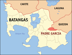
Padre Garcia, officially the Municipality of Padre Garcia (Tagalog: Bayan ng Padre Garcia), is a first class municipality in the province of Batangas, Philippines. According to the 2020 census, it has a population of 51,853 people.[6]
It is recognized as the "Cattle Trading Capital of the Philippines," being notable for its strong agricultural heritage, highlighted by the town’s bustling cattle market, locally known as the bakahan. This livestock auction market has developed into the largest in Southern Tagalog, attracting traders from various regions and serving as a major contributor to the local economy.[7][8]
Etymology
Padre Garcia's old name is Lumang Bayan, as it is the former seat of government of the neighboring town of Rosario. The name of the town is derived from one of its most famous sons, Padre Vicente Garcia, a native of Barangay Maugat. He was one of the first defenders of Jose Rizal's Noli Me Tangere. He and Rizal were friends during the time when they were fighting for the Philippine independence from Spain.[9]
History
The town was originally part of Rosario and known as Lumang Bayan or Sambat. It officially became a separate municipality on December 1, 1949 through Executive Order No. 279 signed by President Elpidio Quirino on October 11, 1949,[10] with Jose A. Pesigan and Rustico K. Recto as the first elected mayor and vice mayor, respectively. It originally consisted of barrios Banaba, Banay-banay, Bawi, Castillo, Maugat, Lumang Bayan (poblacion), Pansol, Payapa, Quilo-quilo, San Miguel, San Felipe, and Tangob.
In 1952, the town council founded the cattle market or bakahan. This was in direct competition to the established livestock market of neighboring Rosario, which resulted in rivalry, intimidation, and violence at times. But the market succeeded and developed into the biggest auction market in Southern Tagalog. Cattle trade happens during every Friday of the week.[9]
Contemporary
On July 28, 2023, the new five-story municipal hall of Padre Garcia was inaugurated.[11]
According to the Philippine Statistics Authority, the municipality has a land area of 41.51 square kilometers (16.03sqmi)[12] constituting 1.33% of the 3,119.75-square-kilometer (1,204.54sqmi) total area of Batangas.
Barangays
Padre Garcia is politically subdivided into 18 barangays, as shown in the matrix below.[13] Each barangay consists of puroks and some have sitios.
The Padre Garcia Schools District Office governs all educational institutions within the municipality. It oversees the management and operations of all private and public, from primary to secondary schools.[30]
Primary and elementary schools
Ages and Stages School of Padre Garcia Batangas
Banaba Elementary School
Bawi Elementary School
Bukal Elementary School
Castillo Elementary School
Cawongan Elementary School
Domingo M. Zuno Elementary School
Holy Family Academy
Holy Trinity School
Magnum Opus Formation School
Manggas-Tamak Elementary School
Maugat East Elementary School
Paaralang Elementarya ng Banaybanay
Padre Garcia Central School
Pansol Elementary School
Payapa Elementary School
Quilo-Quilo Elementary School
Quilo-Quilo North Elementary School
San Felipe Elementary School
San Miguel Elementary School
Tangob Elementary School
Touching Minds Learning Center
Secondary schools
Bukal Integrated National High School
Padre Garcia National High School
Pansol Integrated National High School
Gallery
Parish of the Most Holy Rosary
Old municipal hall
Padre Garcia Health Center
Multi-purpose Hall
References
↑ "House Bill No. 4154"(PDF). House of Representatives of the Philippines. Retrieved December 10, 2016.
This page is based on this Wikipedia article Text is available under the CC BY-SA 4.0 license; additional terms may apply. Images, videos and audio are available under their respective licenses.