This article needs additional citations for verification .(January 2016) |
Alfonso | |
|---|---|
| Municipality of Alfonso | |
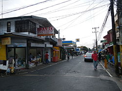 Downtown area | |
 Flag  Seal | |
| Nickname: Agro-Industrial Center of Upland Cavite | |
 Map of Cavite with Alfonso highlighted | |
 Interactive map of Alfonso | |
 Alfonso Location within the Philippines | |
| Coordinates: 14°08′16″N120°51′19″E / 14.137894°N 120.855178°E | |
| Country | Philippines |
| Region | Calabarzon |
| Province | Cavite |
| District | 8th district |
| Founded | 16 May 1859 |
| Named after | Alfonso XII |
| Barangays | 32 (see Barangays) |
| Government | |
| • Type | Sangguniang Bayan |
| • Mayor | Randy A. Salamat |
| • Vice Mayor | Madona M. Pel |
| • Representative | Aniela Bianca D. Tolentino |
| • City Council | Members |
| Area | |
• Total | 66.58 km2 (25.71 sq mi) |
| Elevation | 356 m (1,168 ft) |
| Highest elevation | 779 m (2,556 ft) |
| Lowest elevation | 27 m (89 ft) |
| Population (2024 census) [3] | |
• Total | 60,583 |
| • Density | 909.9/km2 (2,357/sq mi) |
| • Households | 14,556 |
| Economy | |
| • Income class | 1st municipal income class |
| • Poverty incidence | 13.22 |
| • Revenue | ₱ 338.7 million (2022) |
| • Assets | ₱ 660.1 million (2022) |
| • Expenditure | ₱ 259.2 million (2022) |
| • Liabilities | ₱ 229.2 million (2022) |
| Service provider | |
| • Electricity | Manila Electric Company (Meralco) |
| Time zone | UTC+8 (PST) |
| ZIP code | 4123 |
| PSGC | |
| IDD : area code | +63 (0)46 |
| Native languages | Tagalog |
| Website | www |
Alfonso, officially the Municipality of Alfonso (Tagalog : Bayan ng Alfonso), is a municipality in the province of Cavite, Philippines. According to the 2024 census, it has a population of 60,583 people. [5]
