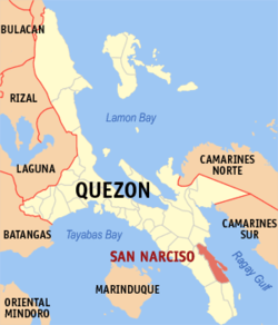
San Narciso, officially the Municipality of San Narciso (Tagalog: Bayan ng San Narciso), is a 1st class municipality in the province of Quezon, Philippines. According to the 2024 census, it has a population of 53,375 people.[5]
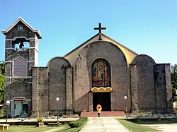
Nuestra Señora de la Paz y Buen Viaje Parish - Abuyon (est. 1994)
Education
The San Narciso Schools District Office governs all educational institutions within the municipality. It oversees the management and operations of all private and public, from primary to secondary schools.[20]
Primary and elementary schools
Abuyon Elementary School
Bangkuro Elementary School
Bani Elementary School
Binay Elementary School
Busokbusokan Elementary School
Calwit Elementary School
Guinhalinan Elementary School
Lakdayan Elementary School
Maguiting Elementary School
Nangka Elementary School
Our Lady of Peace Parochial School of Abuyon
Pinagsama Elementary School
Punta Elementary School
Rizal Elementary School
San Isidro Elementary School
San Juan Elementary School
San Narciso Central Elementary School
San Vicente Elementary School
St. Joseph Parochial School
Vigo Central Elementary School
VIlla Reyes Elementary School
White Cliff Elementary School
Secondary schools
Abuyon National High School
Abuyon National High School (Doña Salud Annex)
Gregorio Reyes National High School
Godofredo M. Tan Memorial Integrated School of Arts and Trades
Lucena (Administratively independent from the province but grouped under Quezon by the Philippine Statistics Authority. However, qualified voters of this city are still allowed to participate in the election of provincial officials as part of Quezon’s 2nd Sangguniang Panlalawigan district.)
This page is based on this Wikipedia article Text is available under the CC BY-SA 4.0 license; additional terms may apply. Images, videos and audio are available under their respective licenses.