
The United Nations Convention on the Law of the Sea (UNCLOS), also called the Law of the Sea Convention or the Law of the Sea Treaty, is an international treaty that establishes a legal framework for all marine and maritime activities. As of October 2024, 169 sovereign states and the European Union are parties.

Territorial waters are informally an area of water where a sovereign state has jurisdiction, including internal waters, the territorial sea, the contiguous zone, the exclusive economic zone, and potentially the extended continental shelf. In a narrower sense, the term is often used as a synonym for the territorial sea.

An exclusive economic zone (EEZ), as prescribed by the 1982 United Nations Convention on the Law of the Sea, is an area of the sea in which a sovereign state has exclusive rights regarding the exploration and use of marine resources, including energy production from water and wind.

Scarborough Shoal, also known as Panacot,Bajo de Masinloc, Huangyan Island, Minzhu Jiao, and Panatag Shoal, are two skerries between Macclesfield Bank to the west and Luzon to the east. Luzon is 220 kilometres (119 nmi) away and the nearest landmass. The atoll is a disputed territory claimed by the Republic of the Philippines through the Treaty of Washington in 1900 via the 1734 Velarde map, as well as by the People's Republic of China and the Republic of China (Taiwan). The atolls' status is often discussed in conjunction with other territorial disputes in the South China Sea, such as those involving the Spratly Islands and the 2012 Scarborough Shoal standoff. In 2013, the Philippines initiated arbitration against China under UNCLOS. In 2016, the tribunal ruled that China's historic title within the nine-dash line was invalid but did not rule on sovereignty.

Kalayaan, officially the Municipality of Kalayaan, is a municipality under the jurisdiction of the province of Palawan, Philippines. According to the 2020 census, it has a population of 193 people making it the least populated town in the Philippines and in Palawan.
In Canadian law, Canadian Internal Waters are the waters "on the landward side of the baselines of the territorial sea of Canada."
The Philippines has claims on territories which include the Spratly Islands, portions of North Borneo, and the Scarborough Shoal.
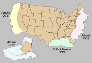
The Outer Continental Shelf (OCS) is a legally defined geographic feature of the United States. The OCS is the part of the internationally recognized continental shelf of the United States which does not fall under the jurisdictions of the individual U.S. states.
Philippines and the Spratly Islands – this article discusses the policies, activities and history of the Republic of the Philippines in the Spratly Islands from the Philippine perspective. Non-Philippine viewpoints regarding Philippine occupation of several islands are currently not included in this article.
The Malaysia–Philippines border is a maritime boundary located in the South China, Sulu and Celebes Seas. It separates the Malaysian state of Sabah, which is on the island of Borneo, and the Sulu Islands of the southern Philippines.
The Philippine Rise, formally designated as Benham Rise, is an extinct volcanic ridge located in the Philippine Sea approximately 250 kilometers (160 mi) east of the northern coastline of Dinapigue, Isabela. The feature has long been known to the people of Catanduanes as Kalipung-awan, which literally means “loneliness from an isolated place”, since the precolonial era.

The territorial waters of Indonesia are defined according to the principles set out in Article 46 of the United Nations Convention on the Law of the Sea. Their boundary consists of straight lines ("baselines") linking 195 coordinate points located at the outer edge of the archipelago ("basepoints").
The sovereignty of the Philippines refers to the status of the Philippines as an independent nation. This article covers sovereignty transitions relating to the Philippines, with particular emphasis on the passing of sovereignty from Spain to the United States in the Treaty of Paris (1898), signed on December 10, 1898, to end the Spanish–American War. US President William McKinley asserted the United States' sovereignty over the Philippines on December 21, 1898, through his Benevolent Assimilation Proclamation.
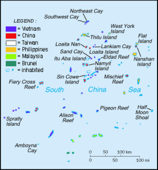
The Spratly Islands dispute is an ongoing territorial dispute among Brunei, China, Malaysia, the Philippines, Taiwan, and Vietnam concerning "ownership" of the Spratly Islands, a group of islands and associated "maritime features" located in the South China Sea. The dispute is characterized by diplomatic stalemate and the employment of military pressure techniques in the advancement of national territorial claims. All except Brunei occupy some of the maritime features.

West Philippine Sea is the official designation by the government of the Philippines to the parts of the South China Sea that are included in the country's exclusive economic zone. The term is also sometimes incorrectly used to refer to the entire South China Sea.
The Treaty of Washington of 1900 was signed on November 7, 1900, and came into effect on March 23, 1901, when the ratifications were exchanged. The treaty sought to remove any ground of misunderstanding growing out of the interpretation of Article III of the 1898 Treaty of Paris by clarifying specifics of territories relinquished to the United States by Spain. It explicitly provided:
Spain relinquishes to the United States all title and claim of title, which she may have had at the time of the conclusion of the Treaty of Peace of Paris, to any and all islands belonging to the Philippine Archipelago, lying outside the lines described in Article III of that Treaty and particularly to the islands of Cagayan [Mapun], Sulu and Sibutu and their dependencies, and agrees that all such islands shall be comprehended in the cession of the Archipelago as fully as if they had been expressly included within those lines.
An archipelagic state is an island country that consists of one or more archipelago. The designation is legally defined by the United Nations Convention on the Law of the Sea of 1982. The Bahamas, Fiji, Indonesia, Papua New Guinea, and the Philippines are the five original sovereign states that obtained approval in the UNCLOS signed in Montego Bay, Jamaica on 10 December 1982 and qualified as the archipelagic states.

The article covers events relevant to the ongoing territorial disputes in the South China Sea. Even before the common era, maritime trading networks had already been established in the high seas of the region. Prior to World War II, China, France, and Japan disputed over the Paracel and Spratly Islands. After the war, Brunei, Malaysia, the People's Republic of China, the Philippines, Taiwan, and Vietnam became involved in the conflict.
The borders of Indonesia include land and maritime borders with Malaysia, Papua New Guinea, and East Timor, as well as shared maritime boundaries with Australia, India, Palau, Philippines, Singapore, Thailand, and Vietnam.
The Philippine Maritime Zones Act, officially designated as Republic Act No. 12064, is a bill passed by the 19th Congress of the Philippines and signed by President Bongbong Marcos on November 7, 2024. It defines the Philippines' internal waters, archipelagic waters, territorial sea, contiguous zone, exclusive economic zone, and continental shelf in line with the 1982 Law of the Sea Convention (UNCLOS) and the 2016 Arbitral Tribunal ruling.

