Lakandula was the regnal name of the last lakan or paramount ruler of pre-colonial Tondo when the Spaniards first conquered the lands of the Pasig River delta in the Philippines in the 1570s.

Malate is a district of Manila, Philippines. Together with the district of Ermita, it serves as Manila's center for commerce and tourism.
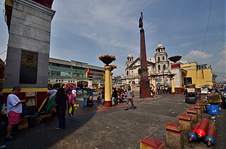
Plaza Miranda is a public square bounded by Quezon Boulevard, Hidalgo Street and Evangelista Street in Quiapo, Manila. It is the plaza which fronts the Minor Basilica of the Black Nazarene, one of the main churches of the City of Manila, and is considered as the center of Quiapo as a whole. Inaugurated in its current form by Mayor Arsenio Lacson in 1961, it is named after José Sandino y Miranda, who served as the Philippines' Secretary of the Treasury between 1833 and 1854.

Jose "Lito" Livioko Atienza Jr. is a Filipino politician serving as the Party-list Representative for Buhay since 2013, and as a House Deputy Speaker since November 2020. He previously served as the Secretary of Environment and Natural Resources from 2007 to 2009 in the administration of President Gloria Macapagal Arroyo. He also served three consecutive terms as Mayor of Manila from 1998 to 2007.

Bay City, also known as the Manila Bay Freeport Zone and Manila Bay Area, is the name for the reclamation area on Manila Bay located west of Roxas Boulevard and the Manila–Cavite Expressway in Metro Manila, the Philippines. The area is split between the cities of Manila and Pasay on the north side and Parañaque on the south.

Roxas Boulevard is a popular waterfront promenade in Metro Manila in the Philippines. The boulevard, which runs along the shores of Manila Bay, is well known for its sunsets and stretch of coconut trees. The divided roadway has become a trademark of Philippine tourism, famed for its yacht club, hotels, restaurants, commercial buildings and parks.

The Our Lady of Remedies Parish, also known as Malate Church, is a parish church in the district of Malate in the city of Manila, Philippines. This Mexican Baroque-style church is overlooking Plaza Rajah Sulayman and, ultimately, Manila Bay. The church is dedicated to Nuestra Señora de los Remedios, the patroness of childbirth. A revered statue of the Virgin Mary in her role as Our Lady of Remedies was brought from Spain in 1624 and stands at the altar.

Rajah Ache, better known by his title Rajah Matanda (1480–1572), was one of the rulers of Maynila, a pre-colonial Indianized and Islamized Tagalog polity along the Pasig River in what is now Manila, Philippines.
The Battle of Manila (1570) was fought in Manila between the native Filipinos led by King Sulayman, and the Spaniards led by Martin de Goiti, maestre de campo, on 24 May 1570. Goiti's forces were victorious and Manila later became the capital of the Spanish East Indies.

Circumferential Road 2 (C-2), informally known as the C-2 Road, is a network of roads and bridges that all together form the second beltway of Metro Manila in the Philippines. Spanning some 10 kilometers (6.2 mi), it connects the districts of Tondo, Santa Cruz, Sampaloc, San Miguel, Santa Mesa, Paco, Pandacan, and Malate in Manila.

Tourism is an important industry in Metro Manila, Philippines. In 2012, the city and region welcomed 974,379 overnight visitors. As the main gateway to the Philippines' many destinations, the city is visited by the majority of international tourists to the country registering a total of 3,139,756 arrivals in 2012. Global Blue ranked Manila eleventh in its "Best Shopping Destinations" in Asia. The city is ranked tenth in MasterCard's global top 20 fastest growing cities for international visitors from 2009-2013.

Pedro Gil Street is an east-west inner city street and a tertiary national road in south-central Manila, Philippines. It is 3.649 kilometers (2.267 mi) long and spans the entire length of Ermita, Malate, Paco and Santa Ana districts, as well as portions of San Andres.

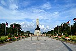
Kalaw Avenue is a short stretch of road in the Ermita district of Manila, Philippines. It forms the southern boundary of Rizal Park running east–west from San Marcelino Street to Roxas Boulevard near the center of the city. It begins as a four-lane road at the intersection with San Marcelino widening to an eight-lane divided roadway along the stretch of Rizal Park from Taft Avenue west to Roxas Boulevard. It has a short extension into the reclaimed area of Luneta and Quirino Grandstand as South Drive. The avenue's main section between Taft Avenue and Roxas Boulevard is assigned as National Route 155 (N155) of the Philippine highway network.
President Elpidio Quirino Avenue, more commonly known as Quirino Avenue, is a 6-10 lane divided highway in Manila, Philippines. It runs for 3.6 kilometers in a northeast–southwest direction from Nagtahan Bridge across from Santa Mesa in the north to Roxas Boulevard in Malate in the south. It passes through Paco and Pandacan districts where it also serves as a truck route between Port Area and South Luzon Expressway. North of Nagtahan Bridge, the road continues as Nagtahan Street. It is designated as part of Circumferential Road 2.
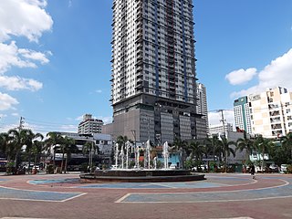
Remedios Circle, also known as the Plaza de la Virgen de los Remedios, Remedios Rotonda, and Rotary Circle, is a traffic circle in Malate, Manila in the Philippines, serving as the intersection between Remedios Street, Jorge Bocobo Street and Adriatico Street. The circle and a traversing street are both named after Nuestra Señora de los Remedios, the patroness of the nearby Malate Church, and is one of two major open spaces in Malate, the other being Plaza Rajah Sulayman.

Marcelo H. del Pilar Street, also known as M.H. del Pilar Street or simply Del Pilar Street, is a north–south road running for 1.895 kilometers (1.177 mi) connecting Ermita and Malate districts in Manila, Philippines. It is a two-lane street which carries traffic one-way southbound from Kalaw Avenue in Rizal Park to Quirino Avenue just across from the Ospital ng Maynila. It was formerly called Calle Real.

The following is an alphabetical list of articles related to the Philippine capital region of Metro Manila.

Plaza Olivia Salamanca, also known simply as Plaza Salamanca, is a public square in Ermita, Manila, bounded by Taft Avenue to the east, Teodoro M. Kalaw Avenue to the north and General Luna Street to the west. It is dedicated to Olivia Salamanca, one of the Philippines' first female physicians, with a historical marker dedicated to her being installed in 1955.

The Silahis International Hotel, later known as the Sofitel Grand Boulevard Hotel, is an abandoned hotel in Manila, Philippines.