Metropolitan Manila, commonly shortened to Metro Manila and formally the National Capital Region, is the capital region and largest metropolitan area of the Philippines. Located on the eastern shore of Manila Bay, the region lies between the Central Luzon and Calabarzon regions. Encompassing an area of 636.00 km2 (245.56 sq mi) and with a population of 13,484,462 as of 2020, it is composed of sixteen highly urbanized cities: the capital city, Manila, Caloocan, Las Piñas, Makati, Malabon, Mandaluyong, Marikina, Muntinlupa, Navotas, Parañaque, Pasay, Pasig, Quezon City, San Juan, Taguig, and Valenzuela, along with one independent municipality, Pateros. As the second most populous and the most densely populated region in the Philippines, it ranks as the 9th most populous metropolitan area in Asia and the 6th most populous urban area in the world.

Sulayman, sometimes referred to as Sulayman III, was a Crown Prince of the Kingdom of Luzon in the 16th century and was a nephew of King Ache of Luzon. He was the commander of Luzonian forces in the battle of Manila of 1570 against Spanish forces.

Intramuros is the 0.67-square-kilometer (0.26 sq mi) historic walled area within the city of Manila, the capital of the Philippines. It is administered by the Intramuros Administration with the help of the city government of Manila.
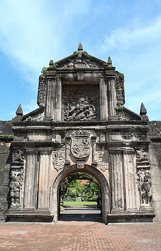
Fort Santiago, built in 1571, is a citadel or castle built by Spanish navigator and governor Miguel López de Legazpi for the newly established city of Manila in the Philippines. The defense fortress is located in Intramuros, the walled city of Manila.
Martín de Goiti was a Spanish conquistador and one of the soldiers who accompanied the Spanish voyage of exploration to the East Indies and the Pacific in 1565, in search of rich resources such as gold, spice and settlements. They were seeking to find a route to the islands were the previous Spanish expeditions led by Ferdinand Magellan had landed in 1521, and Ruy López de Villalobos in 1543.
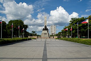
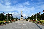
Rizal Park, also known as Luneta Park or simply Luneta, is a historic urban park located in Ermita, Manila. It is considered one of the largest urban parks in the Philippines, covering an area of 58 hectares. The site on where the park is situated was originally known as Bagumbayan during the Spanish colonial period. It is adjacent to the historic Walled City of Intramuros.

The Rizal Shrine, also known as the Museo ni José Rizal Fort Santiago, is a museum dedicated to the lifework of José Rizal. It is located inside Fort Santiago in Intramuros, Manila, Philippines, beside the Plaza de Armas. Fort Santiago served as barracks for Spanish artillery soldiers during Spain's colonization of the islands. The museum is located in the building where Rizal spent his final night and hid his famous poem Mi último adiós in an oil lamp later given to his sister, Trinidad. The shrine is home to various memorabilia such as the shells he collected in Dapitan, books, manuscripts and artwork.

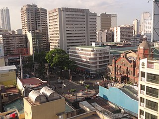
Malate is a district of Manila, Philippines. Together with the district of Ermita, it serves as Manila's center for commerce and tourism.
Eduardo de los Santos Castrillo was a renowned Filipino sculptor.
The earliest recorded history of Manila, the capital of the Philippines, dates back to the year 900 AD, as recorded in the Laguna Copperplate Inscription. By the thirteenth century, the city consisted of a fortified settlement and trading quarter near the mouth of the Pasig River, the river that bisects the city into the north and south.

In Metro Manila, Philippines, tourism is a significant industry. In 2012, the city and the region welcomed 974,379 overnight visitors. Serving as the main gateway to the Philippines' numerous destinations, the city attracts mainly international tourists, with a total of 3,139,756 visitors in 2012. Global Blue ranks Manila as the eleventh 'Best Shopping Destination' in Asia. The city holds the tenth position in MasterCard's global top 20 fastest-growing cities for international visitors from 2009 to 2013.

Plaza de Roma, also known as Plaza Roma, is one of three major public squares in Intramuros, Manila. It is bounded by Andres Soriano Avenue to the north, Cabildo Street to the east, Santo Tomas Street to the south, and General Antonio Luna Street to the west. The plaza is considered to be the center of Intramuros.

Plaza Moriones is a major public square in Tondo, Manila. Unlike other squares in Manila, the plaza is in the shape of a linear park occupying the central median of Moriones Street, starting at the intersection of Moriones and Juan Luna Streets, and ending at the intersection with Santa Maria Street, bisected by Nicolas Zamora Street in the center. It is named after Governor-General Domingo Moriones y Muralla, responsible for the construction of Manila's sewerage system during his tenure from 1877 to 1881.
Plaza Calderón de la Barca is a major public square in Binondo, Manila, bounded by Quintin Paredes Street to the east and Juan Luna Street to the west, parallel to the Estero de Binondo. It is the plaza that fronts the Minor Basilica of San Lorenzo Ruiz, one of the main churches of the City of Manila, and is considered the center of Binondo as a whole.
The following is a timeline of the history of the city and metropolitan area of Manila, the capital city of the Philippines.

The Liwasang Bonifacio, also known by its former name, Plaza Lawton, is a city square and transport hub in front of the Manila Central Post Office in the Ermita district of Manila, Philippines. It lies at the south end of Jones Bridge, MacArthur Bridge, and Quezon Bridge, which link the northern districts of Binondo, Santa Cruz, and Quiapo to the central district of Ermita. The plaza straddles the dividing line between Ermita and Intramuros and is the starting point of Padre Burgos Avenue, which connects to Taft Avenue and Roxas Boulevard in Rizal Park.

The following outline is provided as an overview of and topical guide to Metro Manila:

The following is an alphabetical list of articles related to the Philippine capital region of Metro Manila.

Plaza Moriones is a public square in Intramuros, Manila. Located in front of the entrance to Fort Santiago, it is one of three major plazas in Intramuros, the others being Plaza de Roma located beyond the fort's grounds, and the Plaza de Armas located inside the fort, to which it is often misconstrued for.