
Intramuros is the 0.67-square-kilometer (0.26 sq mi) historic walled area within the city of Manila, the capital of the Philippines. It is administered by the Intramuros Administration with the help of the city government of Manila.

The Church of Saint Augustine, also known as the Archdiocesan Shrine of Our Lady of Consolation and Cincture or the Immaculate Conception Parish, is a Catholic church under the auspices of the Order of Saint Augustine located inside the historic walled city of Intramuros in Manila, Philippines. Completed in 1607, it is the oldest stone church in the country.

The Colegio de San Juan de Letran, also referred to by its acronym CSJL, is a private Catholic coeducational basic and higher education institution owned and run by the friars of the Order of Preachers in Intramuros, Manila, Philippines. It was founded in 1620. Colegio de San Juan de Letran has the distinction of being the oldest college in the Philippines and the oldest secondary institution in Asia. The school has produced Philippine presidents, revolutionary heroes, poets, legislators, members of the clergy, jurists, and it is also one of the only Philippine schools that has produced several Catholic saints who lived and studied on its campus. The school's patron saint is St. John the Baptist. The campus contains two statues, representing the two foremost alumni in the fields of secular and religious service: former Philippine President Manuel L. Quezon and Vietnamese Saint Vicente Liem de la Paz.

Santiago de Vera was a native of Alcalá de Henares, Spain and the sixth Spanish governor of the Philippines, from May 16, 1584, until May 1590.

The Province of the Most Holy Name of Jesus of the Philippines(Spanish: Provincia Agustiniana del Santísimo Nombre de Jesús de Filipinas) was a geographical and administrative subdivision of the religious Order of St. Augustine that was formally affiliated to the Order on March 7, 1575, to originally cater the needs of the growing Augustinian presence in Philippines who were serving Filipinos in more than 300 towns in the 16th century. The Province later on expanded its presence in East Asia, Africa and the Americas in the 20th century to help build and serve more communities. It was considered to be the largest province in the whole Augustinian Order, with more than 300 affiliated Augustinian friars working in The Philippines, Spain, Tanzania, India, Venezuela, Peru, Costa Rica, El Salvador, Honduras, and China, according to a 2018 statistic from the Province.

Ciudad Colonial is the historic central neighborhood of the Dominican Republic's capital Santo Domingo. It is the oldest continuously inhabited European-established settlement in the Americas. The area has been declared a World Heritage Site by UNESCO. It is also known as Zona Colonial or more colloquially as "La Zona".
The gates of Intramuros refer to the original eight gates of the Walled City of Intramuros in Manila, built during the Spanish colonial era in the Philippines. The gates are called by the original Spanish word for "gate", puerta.

San Nicolas is one of the sixteen districts in the city of Manila in the Philippines. It is located at the west central part of the city, on the northern bank of the Pasig River bounded by the districts of Binondo to the east by Estero de Binondo, and Tondo to the north and west, and by the Pasig River to the south. Considered as a heritage district of Manila, this community has kept its 19th-century ancestral houses, which symbolizes the wealthy lives of the people who used to live there, similar to the ancestral houses of Silay and Vigan.

The Spanish fortifications of the Philippines, or fuerzas, are strongholds constructed by Filipinos and Spaniards primarily for protection against local and foreign aggressors during the Spanish colonial period, and during the subsequent American and Japanese occupations. Structures built included fortresses, watchtowers, and bastions. Many are badly damaged, either due to old age or past conflicts. Currently, there are initiatives for restorations of all forts, beginning when the Baluarte Luna of La Union and the Intramuros of Manila were restored in the 2010s. In 2013, a typhoon and earthquake hit Central Visayas and damaged numerous Spanish fortifications, leading to the largest restoration activity for fortifications in Philippine history.

Manila, also known as Tondo until 1859, was a province of the Philippines that encompassed the former pre-Hispanic polities of Tondo, Maynila, and Namayan. In 1898, it comprised the city of Manila and 23 other municipalities. In 1901, the province was dissolved, with the city of Manila absorbing six of its smaller neighboring municipalities. The remaining part was merged with the adjacent district of Morong to form the province of Rizal.
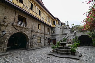
Casa Manila is a museum in Intramuros depicting colonial lifestyle during Spanish colonization of the Philippines.

The Battle of Manila of 1896 occurred in Manila in the Spanish colony of the Philippines during the Philippine Revolution. Katipunan under Andres Bonifacio attempted to take the city but the attempt failed, and Bonifacio retreated to the city's outskirts. The Battle of San Juan del Monte was joined a day later when Bonifacio attempted to capture the San Juan's powder magazine, but this too failed.

Bonifacio Drive is a road running for approximately 1 kilometer (0.62 mi) in a north-south direction between Intramuros and Port Area in Manila, Philippines. The boulevard is also designated as Radial Road 1 (R-1) of Manila's arterial road network, National Route 120 (N120) of the Philippine highway network and an auxiliary route of Asian Highway 26 (AH26).

Mel Lopez Boulevard, formerly known as President Ferdinand E. Marcos Highway or simply as Marcos Road, is a 6.2-kilometer (3.9 mi), six-to-ten lane divided highway in northern Manila, Philippines, connecting Bonifacio Drive in Port Area and Intramuros in the south with Radial Road 10 (R-10) in Navotas in the north. The highway is the main component of the R-10 network, which runs north of the Pasig River until Anda Circle, and is an extension of Bonifacio Drive, running north–south through the Manila North Port area serving the coastal districts of Tondo and Port Area, as well as San Nicolas and Intramuros.

The Baluarte de San Diego is a bastion in Intramuros, part of the Spanish colonial fortification in the walled city of Manila in the Philippines.

Plaza Mexico is a historic riverside square in Manila, Philippines, located at the west end of Magallanes Drive and Riverside Drive in Intramuros bordering the Pasig River in the north. It is surrounded by the Aduana Building on the south, the Bureau of Immigration Building on the east and the ruins of the Bastión de Maestranza and Puerta de Almacenes on the west. The Pasig River Ferry has a station also named Plaza Mexico located northeast of the square behind the Immigration building. The square was named Plaza Mexico in 1964 to commemorate the 4th centenary of the expedition of Miguel López de Legazpi and Andres de Urdaneta from New Spain (Mexico) and the historic Manila-Acapulco galleon trade relations between the two nations that lasted 250 years.

Plaza de España, also known simply as Plaza España, is a diminutive open space in Intramuros, Manila, Philippines formed by the intersection of Andres Soriano Avenue, Solana Street and Muralla Street. It is a triangular "square" which features a monument to King Philip II of Spain after whom the Philippines was named. The square is one of 47 parks and plazas in the City of Manila maintained by the city's Park Development Office in partnership with the Intramuros Administration. It is surrounded by the Aduana Building, the BPI Intramuros building which replaced the old Santo Domingo Church destroyed during World War II, and the Banco Filipino condominium building built on a portion of the old Ayuntamiento de Manila.

Circumferential Road 1 (C-1), informally known as the C-1 Road, is a network of roads and bridges that all together form the first and innermost beltway of Metro Manila in the Philippines. Spanning some 5.98 kilometers (3.72 mi), it connects the districts of Ermita, Intramuros, San Miguel, Quiapo, Sampaloc, Santa Cruz, Binondo, San Nicolas, and Tondo in Manila.

Old Town of Cáceres is a historic walled city in Cáceres, Spain.

The Binondo–Intramuros Bridge is a tied-arch bridge in Manila, Philippines that spans the Pasig River. It connects Muelle de Binondo in Binondo and in San Nicolas to Solana Street and Riverside Drive in Intramuros. The bridge has four lanes and exhibits a steel bowstring arch design with inclined arches. It has a length of 680 meters (2,230 ft).


