Plaza Moriones, Intramuros

Last updated
Plaza Moriones
Public square
Former name(s): Plaza de la Fuerza
Fort Santiago, Plaza Moriones (Intramuros, Manila; 11-10-2019).jpg
Dedicated toDomingo Moriones y Muralla
OwnerCity of Manila
Location Fort Santiago, Intramuros
Manila, Philippines
Coordinates: 14°35′35.9″N120°58′16.5″E / 14.593306°N 120.971250°E / 14.593306; 120.971250

Plaza Moriones is a public square in Intramuros, Manila. Located in front of the entrance to Fort Santiago, it is one of three major plazas in Intramuros, the others being Plaza de Roma located beyond the fort's grounds, and the Plaza de Armas located inside the fort, to which it is often misconstrued for. [1]

Contents

History

This 1898 map of Manila was the first to call Plaza Moriones that name. Intramuros Manila 1898.jpg
This 1898 map of Manila was the first to call Plaza Moriones that name.

Attested in maps of Manila dating back to at least 1671, [2] Plaza Moriones was originally known as the Plaza de la Fuerza, [2] an empty lot which served as a military promenade for soldiers barracked inside Fort Santiago. It served in this role before the fort was damaged in the 1863 earthquake that devastated Manila, [3] after which it was converted into temporary military barracks. By 1875, the plaza was once again empty, [4] and as early as 1898, the plaza was already called the Plaza del General Moriones, after Domingo Moriones y Muralla, who served as Governor General from 1877 to 1881. [5]

During the American colonial period, the plaza retained its function as a parade ground for soldiers, [6] but in the 1930s, according to a manuscript written by H. Otley Beyer, the United States Army — which was headquartered inside Fort Santiago at the time — took over the plaza and built soldiers’ quarters there. [2]

With Intramuros virtually destroyed in the Battle of Manila during World War II, Plaza Moriones reverted to open space, [2] even serving as a parking lot for cars and tour buses for years after the war. [6] The reconstruction of Intramuros eventually prompted its redevelopment, planned as early as 1973, and completed twice by the Intramuros Administration: first in 1993, and again in 2017. [4]

Architecture

The former gardens of Plaza Moriones, taken in 2011. Intramuros Garden.jpg
The former gardens of Plaza Moriones, taken in 2011.

Plaza Moriones was originally bare open space, with the plaza being documented as having grass as early as 1875. [4] By 1903, despite still being considered an "unremarkable" space, [4] the plaza had a few trees growing around its periphery, and by the 1930s, aerial photos show that trees were found growing on the northern side of the plaza, close to the fort's entrance, while the southern side remained open space. [2] After World War II, the plaza reverted to being largely covered in grass, [2] although shrubbery was planted in 1983. [4] Concrete paths and a fountain were also installed in the 1980s. [2]

Plans to redevelop the plaza were first conceptualized in 1973 as part of the Development Plan for Intramuros presented by the Spanish government, in which the plaza was envisioned as a “cultural-recreational area". [4] In the early 1990s, the Intramuros Administration commissioned landscape architect Dolly Perez to redesign the plaza. Perez's redesign, completed in 1993, transformed the space into a garden with flora typical of 19th-century gardens. [2] As part of the redesign, trees were planted and, in keeping with the general historical appearance of Intramuros, the plaza's walkways and low walls were framed in natural adobe and brick. [6] This remained the general appearance of Plaza Moriones for nearly 25 years, making it a popular location for picnics, wedding receptions and dog walking. [4]

2017 redevelopment

In 2014, the Intramuros Administration proceeded with a second redevelopment of Plaza Moriones, part of a 240 million, ten-part redevelopment of Fort Santiago as a whole, and falling in line with its long-term plan for the wider redevelopment of Intramuros. [2] The redeveloped Plaza Moriones was reopened by the Department of Tourism (DOT) on April 17, 2017, and funded by the Tourism Infrastructure and Enterprise Zone Authority (TIEZA), an attached agency of the DOT. [7]

Plaza Moriones in 2020 during COVID-19 quarantine. Fort Santiago - no people (Intramuros, Manila; 07-22-2020).jpg
Plaza Moriones in 2020 during COVID-19 quarantine.

As part of the plaza's redevelopment, intended to restore the plaza to its original function as a parade ground, the gardens were replaced with granite paving, with specified areas for manicured planting arrangements within the plaza's periphery, [6] including a number of kalachuchi (frangipani) trees festooned with capiz shell lamps near the entrance to Fort Santiago. [8] This allows for unobstructed views of the fort's gate from Santa Clara Street, which bounds the plaza's southern end, as well as the Manila Cathedral from the plaza's northern end. [8] A new fountain was also installed in the center of the plaza. [5]

The redevelopment was controversial, eliciting criticism from tour guide and cultural activist Carlos Celdran, who complained that the IA "paved over my heart" after discovering the renovations as he was returning from a trip abroad. [4] Celdran later remarked that the renovations looked "flat, anonymous, and [it] has nothing to do with Intramuros' character or history", even calling it the "plaza from TriNoma" and denouncing the project as a waste of taxpayers' money. [2] The IA didn't conduct public consultations on the redevelopment project, as it was not required by law to do so, [4] but people who use the plaza regularly have, according to architect Augusto F. Villalon, lamented the loss of its park-like atmosphere, especially considering Manila's lack of green, open spaces. [6] In its defense, the IA emphasized that it consulted landscape architects and heritage experts when the project was first conceived in 2014, [2] and Celdran himself has noted that he was nevertheless coordinating closely with stakeholders on the matter. [4]

See also

Related Research Articles

<span class="mw-page-title-main">Intramuros</span> Historic walled city and district of Manila, Philippines

Intramuros, is the 0.67-square-kilometer (0.26 sq mi) historic walled area within the city of Manila, the capital of the Philippines. It is administered by the Intramuros Administration with the help of the city government of Manila.

<span class="mw-page-title-main">Fort Santiago</span> 16th-century citadel in Manila, Philippines

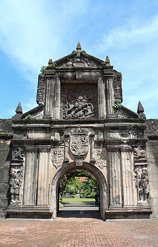
Fort Santiago, built in 1571, is a citadel built by Spanish navigator and governor Miguel López de Legazpi for the newly established city of Manila in the Philippines. The defense fortress is located in Intramuros, the walled city of Manila.

<span class="mw-page-title-main">Baroque Churches of the Philippines</span> Baroque churches included in UNESCO World Heritage Site list

The Baroque Churches of the Philippines are a collection of four Spanish Colonial-era baroque churches in the Philippines, which were included in UNESCO's World Heritage List in 1993. The churches are also considered as national cultural treasures of the country.

<span class="mw-page-title-main">Manila Metropolitan Theater</span> Arts center in Manila, Philippines

The Manila Metropolitan Theater, also known as the Metropolitan Theater, abbreviated as the MET, is a historic Philippine Art Deco building located in Plaza Lawton in Ermita, Manila. It is recognized as the forefront of the Art Deco architectural style in the Philippines.

The gates of Intramuros refer to the original eight gates of the Walled City of Intramuros in Manila, built during the Spanish colonial era in the Philippines. The gates are called by the original Spanish word for "gate", puerta.

<span class="mw-page-title-main">Jones Bridge</span> Bridge in Manila, Philippines

The William A. Jones Memorial Bridge, commonly known as the Jones Bridge, is an arched girder bridge that spans the Pasig River in the City of Manila, Philippines. It is named after the United States legislator William Atkinson Jones, who served as the chairman of the U.S. Insular Affairs House Committee which had previously exercised jurisdiction over the Philippines and the principal author of the Jones Law that gave the country legislative autonomy from the United States. Built to replace the historic Puente de España in the 1910s, the bridge connects Quintin Paredes Road at the Binondo district to Padre Burgos Avenue at the Ermita district.

<span class="mw-page-title-main">Jaime C. Laya</span> Filipino banker

Jaime del Carmen Laya, better known as Jimmy Laya is a Filipino banker, accountant, and cultural administrator who served as the first Secretary of the Department of Budget and Management of the Republic of the Philippines, serving from 1978 to 1981. He was also the 5th governor of the Central Bank of the Philippines from 1981 to 1984 and later served as the Minister of Education, Culture and Sports from 1984 until 1986. His terms in civil service, covered two significant points in Philippine history, the election that made former President Ferdinand Marcos have his third term and the assassination of the late Senator Benigno S. Aquino Jr. that stimulated the People Power Revolution of 1986.

<span class="mw-page-title-main">Plaza de Roma</span>

Plaza de Roma, also known as Plaza Roma, is one of three major public squares in Intramuros, Manila. It is bounded by Andres Soriano Avenue to the north, Cabildo Street to the east, Santo Tomas Street to the south, and General Antonio Luna Street to the west. The plaza is considered to be the center of Intramuros.

<span class="mw-page-title-main">Plaza Moriones</span>

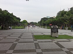
Plaza Moriones is a major public square in Tondo, Manila. Unlike other squares in Manila, the plaza is in the shape of a linear park occupying the central median of Moriones Street, starting at the intersection of Moriones and Juan Luna Streets, and ending at the intersection with Santa Maria Street, bisected by Nicolas Zamora Street in the center. It is named after Governor-General Domingo Moriones y Muralla, responsible for the construction of Manila's sewerage system during his tenure from 1877 to 1881.

<span class="mw-page-title-main">Plaza de Armas (Manila)</span>

The Plaza de Armas is a public square in Intramuros, Manila. The central plaza of Fort Santiago, it is one of three major plazas in Intramuros, the others being the central Plaza de Roma outside the fort grounds, and Plaza Moriones, a larger plaza outside Fort Santiago which was once a military promenade before it was closed in the 1863 earthquake that devastated Manila. While Plaza Moriones is outside the walls of Fort Santiago, both plazas are often misconstrued for the other.

<span class="mw-page-title-main">Plaza San Lorenzo Ruiz</span>

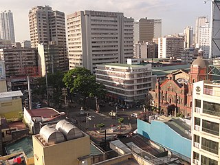
Plaza San Lorenzo Ruiz or Plaza Lorenzo Ruiz is a major public square in Binondo, Manila, bounded by Quintin Paredes Street to the east and Juan Luna Street to the west, parallel to the Estero de Binondo. It is the plaza that fronts the Minor Basilica of San Lorenzo Ruiz, one of the main churches of the City of Manila, and is considered the center of Binondo as a whole.

<span class="mw-page-title-main">Aduana Building</span> Historic building in Manila, Philippines

The Aduana Building, also known as the Intendencia, was a Spanish colonial structure in Manila, Philippines, that housed several government offices through the years. It is located in front of the BPI Intramuros at Plaza España, Soriano (Aduana) Ave. corner Muralla St. in Intramuros.

<span class="mw-page-title-main">Ayuntamiento de Manila</span>

The Ayuntamiento de Manila is a building located at the corner of Andrés Soriano Avenue and Cabildo Street, fronting Plaza de Roma in Intramuros, Manila, Philippines. Also known as the Casas Consistoriales and also nicknamed as the Marble Palace, the Ayuntamiento was the seat of the Manila City Council, which consisted of two alcaldes, eight oidores (judges), a clerk, and a chief constable. Destroyed in World War II and reconstructed thereafter, the building now houses the offices of the Bureau of the Treasury.

<span class="mw-page-title-main">Casino Español de Manila</span> Socio-civic club for Hispano-Filipinos

Casino Español de Manila is a club established in 1888 by Spaniards living in the Philippines as their exclusive venue for recreational and social activities. It later opened its doors to Filipino members to foster Spanish-Filipino ties in the country. It is located at No. 855 Teodoro M. Kalaw Extension, Ermita, Manila.

<span class="mw-page-title-main">Arroceros Urban Forest Park</span> Urban forest park in Manila, Philippines

The Arroceros Forest Park is a riverside urban forest park in Manila, Philippines, located on Antonio Villegas Street in the central district of Ermita.

<span class="mw-page-title-main">Plaza de España (Manila)</span> Open space in Intramuros, Manila, Philippines

Plaza de España, also known simply as Plaza España, is a diminutive open space in Intramuros, Manila, Philippines formed by the intersection of Andres Soriano Avenue, Solana Street and Muralla Street. It is a triangular "square" which features a monument to King Philip II of Spain after whom the Philippines was named. The square is one of 47 parks and plazas in the City of Manila maintained by the city's Park Development Office in partnership with the Intramuros Administration. It is surrounded by the Aduana Building, the BPI Intramuros building which replaced the old Santo Domingo Church destroyed during World War II, and the Banco Filipino condominium building built on a portion of the old Ayuntamiento de Manila.

<span class="mw-page-title-main">National Museum of Natural History (Manila)</span> Natural history museum

The National Museum of Natural History is the national natural history museum of the Philippines. It is located along Agrifina Circle in Rizal Park, Manila.

Museo de Intramuros is an ecclesiastical museum operated and managed by the Intramuros Administration. It is located at the reconstructed San Ignacio Church and Convent within the historic walled area of Intramuros in Manila, Philippines.

The Intramuros Administration (IA) is an agency of the Department of Tourism of the Philippines that is mandated to orderly restore, administer, and develop the historic walled area of Intramuros that is situated within the modern City of Manila as well as to insure that the 16th- to 19th-century Philippine-Spanish architecture remains the general architectural style of the walled area.

<span class="mw-page-title-main">Plaza Rueda</span>

Plaza Rueda is a public square in Ermita, Manila, bounded by Taft Avenue to the west, United Nations Avenue to the north and General Luna Street to the east.

References

  1. "A Walk in the Park: 10 Manila Parks to Visit". SPOT.ph. Summit Media. Archived from the original on February 22, 2014. Retrieved July 2, 2013.
  2. 1 2 3 4 5 6 7 8 9 10 11 "VERA FILES FACT SHEET: Plaza Moriones in Intramuros". Vera Files. May 12, 2017. Archived from the original on April 7, 2020. Retrieved April 6, 2020.
  3. "Fort Santiago". Intramuros Administration. Archived from the original on July 25, 2013. Retrieved July 2, 2013.
  4. 1 2 3 4 5 6 7 8 9 10 Bueno, Anna (March 31, 2017). "What you need to know about the Intramuros rehabilitation". CNN Philippines. Archived from the original on April 7, 2020. Retrieved April 6, 2020.
  5. 1 2 "Fort Santiago Opens New Areas" (Press release). Intramuros Administration . Retrieved April 6, 2020.
  6. 1 2 3 4 5 Villalon, Augusto F. (March 6, 2017). "Updating Plaza Moriones in Intramuros". Philippine Daily Inquirer . Archived from the original on April 7, 2020. Retrieved April 6, 2020.
  7. Parrocha, Azer N. (April 18, 2017). "Fort Santiago's Paseo Soledad, Plaza Moriones get facelift". Manila Bulletin . Archived from the original on April 7, 2020. Retrieved April 6, 2020.
  8. 1 2 Chee Kee, Raoul J. (January 22, 2020). "Why you should check out Intramuros now". Philippine Daily Inquirer . Archived from the original on January 22, 2020. Retrieved April 9, 2020.