Glorieta Park

Last updated
Glorieta Park
9848Caloocan City Barangays Landmarks 01.jpg
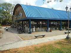
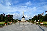
Glorieta Park in Barangay 187, Tala, Caloocan
Glorieta Park
TypeUrban park
Location Caloocan, Philippines
Coordinates 14°46′3.356″N121°3′34.47″E / 14.76759889°N 121.0595750°E / 14.76759889; 121.0595750 Coordinates: 14°46′3.356″N121°3′34.47″E / 14.76759889°N 121.0595750°E / 14.76759889; 121.0595750
Operated byLocal Government of Caloocan
StatusOpened

Glorieta Park, sometimes spelled Glorietta Park, is an urban park in Caloocan, northern Metro Manila, the Philippines. It is situated near the border of barangays 187 and 188 (Zone 16, District III) in the former Tala Estate in North Caloocan. The park is one of three city-owned parks in Caloocan under the management of the Caloocan Parks Administration Services, the others being the Buena Park and Sports Complex in South Caloocan and the Caloocan Amparo Nature Park in eastern Tala, North Caloocan. [1]

Contents

The park occupies the central section of the former 808-hectare (2,000-acre) friar estate known as Hacienda Tala in the old municipality of Novaliches. This estate was purchased by the Philippine Commonwealth government under President Manuel Luis Quezon in 1938 for use as a leper colony to decongest and eventually replace the San Lazaro Hospital for Hansenites in Manila. [2] The Central Luzon Leprosarium, built in 1940, was eventually reduced to an area of 130 hectares (320 acres) in 1971 through Proclamation No. 843 issued by President Ferdinand Marcos which set aside 50 hectares (120 acres) for the National Housing Authority (Philippines), 20 hectares (49 acres) for the Caloocan local government for use as a civic center containing its city hall, public high school, stadia and park to be located at its geographic center, 10 hectares (25 acres) for the Department of Social Welfare and Development bordering the planned civic center, and the remaining 589 hectares (1,460 acres) for housing and resettlement sites to be administered by the People's Homesite and Housing Corporation. [3] [4]

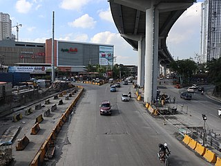
Glorieta Park is bordered by Dr. Uyguanco Avenue, Langit Road, San Jose Street, and Quezon Drive Park and is the largest open space and recreation area in Barangay 187. It features a children's playground and the Glorieta Multi-Purpose Gymnasium, a covered court formerly known as the Glorieta Kiosk. [5] The Our Lady of Holy Rosary Parish Church borders the park to the north. It is also the location of the Tala Health Center, the Tala Post Office, the Tala United Methodist Church and Holy Rosary College. The barangay hall of Barangay 187 lies immediately to the east on Dr. Uyguanco Avenue. It is accessible from the Caloocan districts of Camarin and Bagong Silang on the south and west via the Zabarte/Old Zabarte Road and Langit Road, and from Novaliches, Greater Lagro and Fairview on the east and southeast via Quirino Highway and Dr. Uyguanco Avenue.

In February 2012, as part of the city's 50th anniversary, the Caloocan city government under Mayor Enrico Echiverri hosted a mass wedding at the Glorieta Park wherein a total of 1,510 couples were wed in an attempt to beat India's Guinness record for holding the world's largest mass wedding. [6] [7]

In October 2015, Mayor Oscar Malapitan formally inaugurated the 568.75-square-meter (6,122.0 sq ft) Glorieta Amphitheater within the park which has a seating capacity of 1,500 and which will serveas a venue to showcase the talents and skills of Caloocanians. [8] The amphitheater, which cost 35 million to build, was approved in the 2014 Caloocan City Supplemental Budget No. 14 under its Sangguniang Panlungsod Ordinance No. 0541. [9]

Under the Caloocan City Comprehensive Development Plan 2017–2019, the Caloocan local government plans to construct additional sports facilities within the park, as well as a lagoon and fountain at the left and right side of the covered court, and a perimeter fence with lamp posts. The plan also includes the installation of a permanent front and back door access to the park for VIP use. [1]

See also

Related Research Articles

<span class="mw-page-title-main">Rizal</span> Province in Calabarzon, Philippines

Rizal, officially the Province of Rizal, is a province in the Philippines located in the Calabarzon region in Luzon. Its capital is the city of Antipolo. It is about 16 kilometres (9.9 mi) east of Manila. The province is named after José Rizal, one of the main national heroes of the Philippines. Rizal is bordered by Metro Manila to the west, Bulacan to the north, Quezon to the east and Laguna to the southeast. The province also lies on the northern shores of Laguna de Bay, the largest lake in the country. Rizal is a mountainous province perched on the western slopes of the southern portion of the Sierra Madre mountain range.

<span class="mw-page-title-main">Quezon City</span> Largest city and highly urbanized city in the Philippines

Quezon City, also known as the City of Quezon and Q.C., is the most populous city in the Philippines. According to the 2020 census, it has a population of 2,960,048 people. It was founded on October 12, 1939, and was named after Manuel L. Quezon, the second president of the Philippines.

<span class="mw-page-title-main">Caloocan</span> Highly urbanized city in Metro Manila, Philippines

Caloocan, officially the City of Caloocan, is a 1st class highly urbanized city in Metropolitan Manila, Philippines. According to the 2020 census, it has a population of 1,661,584 people  making it the fourth-most populous city in the Philippines.

<span class="mw-page-title-main">Valenzuela, Metro Manila</span> Highly Urbanized City in Metro Manila, Philippines

Valenzuela, officially the City of Valenzuela, is a 1st class highly urbanized city in the National Capital Region of the Philippines. According to the 2020 census, it has a population of 714,978 people. 

<span class="mw-page-title-main">Novaliches</span> Place in National Capital Region, Philippines

Novaliches is a place that forms the northern areas of Quezon City, and encompasses the whole area of North Caloocan.

This is a list of current and former national capital cities in the Philippines, which includes during the time of the Spanish colonization, the First Philippine Republic, the Commonwealth of the Philippines, the Second Republic of the Philippines, the Third Republic of the Philippines, the Fourth Republic of the Philippines and the current Fifth Republic of the Philippines.

<span class="mw-page-title-main">La Consolacion College – Novaliches</span> Private institution

La Consolacion College – Novaliches, also known by its former name La Consolacion College - Deparo or colloquially LaCo [pronounced as /lakô/]) is a private Catholic basic and higher educational institution administered by the Augustinian Sisters of Our Lady of Consolation (ASOLC).< in Caloocan City, Philippines. It was founded in February 1995 and is one of the two La Consolacion schools in the city of Caloocan, and one of the 24 schools owned and administered by the Augustinian Sisters.

<span class="mw-page-title-main">Roman Catholic Diocese of Novaliches</span> Roman Catholic diocese in the Philippines

The Roman Catholic Diocese of Novaliches is a diocese of the Latin Church of the Roman Catholic Church in the Philippines. The diocese was created by Pope John Paul II on December 7, 2002, by virtue of his Apostolic Constitution Animarum Utilitati, and was canonically erected on January 16, 2003, from the Archdiocese of Manila. The diocese previously existed as the Ecclesiastical District of Quezon City-North, which was renamed the District of Novaliches in 2002.

<span class="mw-page-title-main">Quirino Highway</span> Road in the Philippines

The Quirino Highway, formerly called the El Quirino Express Road or Ipo Road, is a four-to-eight lane, secondary highway that connects Quezon City to the municipality of Norzagaray in Bulacan, Philippines. The road is a designated as National Route 127 (N127) of the Philippine highway network within the city bounds of Quezon City, Radial Road 7 (R-7), and a spur of Radial Road 8 (R-8) of Metro Manila's arterial road network.

<span class="mw-page-title-main">Novaliches Cathedral</span> Church in Quezon City, Philippines

Novaliches Cathedral, canonically recognized as the Cathedral-Shrine and Parish of the Good Shepherd, is a Roman Catholic church located along Regalado Avenue in Barangay Fairview, Quezon City in the Philippines. It is the seat of the Diocese of Novaliches. It was established on August 5, 1975 by Manila Archbishop Jaime L. Cardinal Sin, who designated Rev. Fr. Fidelis Ruben Limcaco as the church's first parish priest.

Metro Manila, the capital region of the Philippines, is a large metropolitan area that has several levels of subdivisions. Administratively, the region is divided into seventeen primary local government units with their own separate elected mayors and councils who are coordinated by the Metropolitan Manila Development Authority, a national government agency headed by a chairperson directly appointed by the Philippine president. The cities and municipality that form the region's local government units are further divided into several barangays or villages which are headed by an elected barangay captain and barangay council.

<span class="mw-page-title-main">Bagong Silang</span> Barangay in Caloocan, Philippines

Bagong Silang or Barangay 176 is a barangay of Caloocan, Metro Manila, Philippines. It is known for being the most populous barangay in the Philippines, with a population of 261,729 according to the 2020 census. It is also the northernmost barangay of Metro Manila located in the northern section of the city bordering the province of Bulacan.

<span class="mw-page-title-main">La Mesa Watershed Reservation</span> Protected area in Metro Manila, Philippines

The La Mesa Watershed Reservation is a protected area that preserves the only major watershed in Metro Manila, Philippines. Also known as the Novaliches Watershed, it contains the last remaining rainforest of its size in Metro Manila surrounding the La Mesa Dam and Reservoir, the primary source of potable drinking water for 12 million residents in the Manila metropolitan area. The area is under the joint administration, supervision and control of the Department of Environment and Natural Resources and the Metropolitan Waterworks and Sewerage System. It was established in 2007 through Proclamation No. 1336 issued by President Gloria Arroyo.

<span class="mw-page-title-main">West Avenue (Quezon City)</span>

West Avenue is a major road located in Quezon City within the Diliman area of northeastern Metro Manila, Philippines. It runs north–south through the western edge of the barangay of West Triangle. The street is located in Quezon City's commercial-residential area, known for its restaurants, car shops, schools, and villages. It is also home to the old Delta theater located on the avenue's junction with Quezon Avenue. The avenue is a component of National Route 171 (N171) of the Philippine highway network.

<span class="mw-page-title-main">East Avenue (Quezon City)</span>

East Avenue is a major street located within the Diliman area of Quezon City, Philippines. It runs north–south through the eastern edge of Triangle Park. The street is located in Quezon City's government area, known for different national and local government institutions, offices, and hospitals. It is also home to the Quezon City Hall Complex located on the avenue's junction with Elliptical Road. The entire avenue is designated as National Route 174 (N174) of the Philippine highway network.

<span class="mw-page-title-main">Balingasa</span> Barangay in National Capital Region, Philippines

Balingasa, commonly known as Balintawak and Cloverleaf, is an administrative division in eastern Metro Manila, the Philippines. It is an urban barangay located in Quezon City, at the city's western boundary with Caloocan.

Barangay BF Homes Caloocan or Barangay 169 is a barangay of Caloocan, Metro Manila, Philippines. The barangay is known for having jurisdiction of the larger portions of the Banco Filipino-developed real estate projects in Northern Manila, and is considered the most affluent barangay in Caloocan.

References

  1. 1 2 "Caloocan City Comprehensive Development Plan 2017–2019" (PDF). City Government of Caloocan. Retrieved 19 March 2018.
  2. "Leprosy in the Philippines". Department of Science and Technology . Retrieved 19 March 2018.
  3. "About DJNRMH". Dr. Jose N. Rodriguez Memorial Hospital . Retrieved 19 March 2018.
  4. "Proclamation No. 843, s. 1971". Official Gazette (Philippines) . Retrieved 19 March 2018.
  5. "Barangay Profile". Local Government of Barangay Tala (187). Retrieved 19 March 2018.
  6. "Caloocan eyes Guinness World Record for most number of couples in mass wedding". Spot.ph. 14 February 2012. Retrieved 19 March 2018.
  7. Botial, J. (14 February 2012). "Caloocan wants record for largest mass wedding". The Philippine Star . Retrieved 19 March 2018.
  8. "New Caloocani amphitheater to be inaugurated tomorrow". City Government of Caloocan. 23 October 2015. Retrieved 19 March 2018.
  9. "Tender Detail". Tender Tiger. Retrieved 19 March 2018.