Manila, officially the City of Manila, is the capital and second-most populous city of the Philippines, after Quezon City. Located on the eastern shore of Manila Bay on the island of Luzon, it is classified as a highly urbanized city. Manila is the world's most densely populated city proper, with 43,611.5 inhabitants per square kilometer (112,953/sq mi) and a population of 1,846,513 people in 2020; it is also the historic core of a built-up area that extends well beyond its administrative limits and includes some 24 million people. Manila was the first chartered city in the country, designated by Philippine Commission Act No. 183 on July 31, 1901. It became autonomous with the passage of Republic Act No. 409, "The Revised Charter of the City of Manila", on June 18, 1949. Manila is considered to be part of the world's original set of global cities because its commercial networks were the first to extend across the Pacific Ocean and connect Asia with the Spanish Americas through the galleon trade. This marked the first time an uninterrupted chain of trade routes circling the planet had been established.

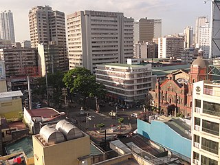
Binondo is a district in Manila and is referred to as the city's Chinatown. Its influence extends beyond to the places of Quiapo, Santa Cruz, San Nicolas and Tondo. It is the oldest Chinatown in the world, established in 1594 by the Spaniards as a settlement near Intramuros but across the Pasig River for Catholic Chinese; it was positioned so that the colonial administration could keep a close eye on their migrant subjects. It was already a hub of Chinese commerce even before the Spanish colonial period. Binondo is the center of commerce and trade of Manila, where all types of business run by Chinese Filipinos thrive.

Carriedo station is an elevated Light Rail Transit (LRT) station located on the LRT Line 1 (LRT-1) system along the district boundary of Santa Cruz and Quiapo in Manila.

Santa Cruz is a district in the northern part of the City of Manila, Philippines, located on the right bank of the Pasig River near its mouth, bordered by the districts of Tondo, Binondo, Quiapo, and Sampaloc, as well as the areas of Grace Park and Barrio San Jose in Caloocan and the district of La Loma in Quezon City. The district belongs to the 3rd congressional district of Manila.

San Nicolas is one of the sixteen districts in the city of Manila in the Philippines. It is located at the west central part of the city, on the northern bank of the Pasig River bounded by the districts of Binondo to the east by Estero de Binondo, and Tondo to the north and west, and by the Pasig River to the south. Considered as a heritage district of Manila, this community has kept its 19th-century ancestral houses, which symbolizes the wealthy lives of the people who used to live there, similar to the ancestral houses of Silay and Vigan.

The William A. Jones Memorial Bridge, commonly known as the Jones Bridge, is an arched girder bridge that spans the Pasig River in Manila, Philippines. It is named after the United States legislator William Atkinson Jones, who served as the chairman of the U.S. Insular Affairs House Committee, which had previously exercised jurisdiction over the Philippines and was the principal author of the Jones Law that gave the country legislative autonomy from the United States. Built to replace the historic Puente de España in the 1910s, the bridge connects Quintin Paredes Road in the Binondo district to Padre Burgos Avenue in the Ermita district.

The Puente de España was a bridge that spanned the Pasig River in the Philippines, connecting the areas of Binondo and Ermita, Manila, on Calle Nueva with central Manila. The span was the oldest established in the country before it was damaged by a flood in 1914. The bridge was replaced by the Jones Bridge, constructed from 1919 to 1921, located one block downriver from Puente de España on Calle Rosario.

In Metro Manila, Philippines, tourism is a significant industry. In 2012, the city and the region welcomed 974,379 overnight visitors. Serving as the main gateway to the Philippines' numerous destinations, the city attracts mainly international tourists, with a total of 3,139,756 visitors in 2012. Global Blue ranks Manila as the eleventh 'Best Shopping Destination' in Asia. The city holds the tenth position in MasterCard's global top 20 fastest-growing cities for international visitors from 2009 to 2013.
Plaza San Lorenzo Ruiz or Plaza Lorenzo Ruiz is a major public square in Binondo, Manila, bounded by Quintin Paredes Street to the east and Juan Luna Street to the west, parallel to the Estero de Binondo. It is the plaza that fronts the Minor Basilica of San Lorenzo Ruiz, one of the main churches of the City of Manila, and is considered the center of Binondo as a whole.

Parián or Pantin, also Parián de Arroceros was an area adjacent to Intramuros at its east built to house Sangley (Chinese) merchants in Manila in the 16th and 17th centuries during the Spanish rule in the Philippines. The place gave its name to the gate connecting it to Intramuros, the Puerta del Parián.

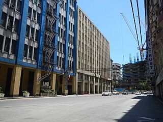
Escolta Street is a historic east–west street in the old downtown district of Binondo in Manila, Philippines. It runs parallel to the Pasig River from Quintin Paredes Road to Plaza Santa Cruz Road. The street is home to several fine examples of early skyscraper design in the Philippines.

Claro M. Recto Avenue, more popularly known as simply Recto, is the principal commercial thoroughfare in north-central Manila, Philippines. It spans six districts just north of the Pasig River in what is generally considered Manila's old downtown area.

Pedro Gil Street is an east-west inner city street and a tertiary national road in south-central Manila, Philippines. It is 3.65 kilometers (2.27 mi) long and spans the entire length of Ermita, Malate, Paco, and Santa Ana. The street is served by the Pedro Gil LRT Station along Taft Avenue and the Paco railway station along Quirino Avenue. It also continues towards the central Metro Manila cities of Mandaluyong and San Juan across the Pasig River as New Panaderos and General Kalentong Streets.
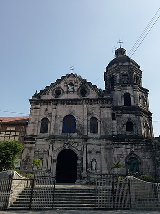
The National Shrine of Our Lady of the Abandoned, also known as Santa Ana Church, is a Spanish colonial period Roman Catholic church located in the district of Santa Ana in Manila, Philippines. It is under the jurisdiction of the Archdiocese of Manila. The parish was established by the Franciscan missionaries in 1578 under the patronage of Saint Anne. The present stone church was constructed by Vicente Inglés from 1720 to 1725 and was dedicated to its present patron, the Our Lady of the Abandoned. The revered image of its patron was made in Valencia, Spain in 1713 and arrived in the Philippines in 1717.

Lucky Chinatown is a lifestyle mall development of Megaworld Lifestyle Malls located along Reina Regente Street corner Dela Reina Street in Binondo, Manila.

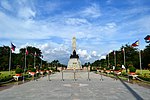
The Liwasang Bonifacio, also known by its former name, Plaza Lawton, is a city square and transport hub in front of the Manila Central Post Office in the Ermita district of Manila, Philippines. It lies at the south end of Jones Bridge, MacArthur Bridge, and Quezon Bridge, which link the northern districts of Binondo, Santa Cruz, and Quiapo to the central district of Ermita. The plaza straddles the dividing line between Ermita and Intramuros and is the starting point of Padre Burgos Avenue, which connects to Taft Avenue and Roxas Boulevard in Rizal Park.

The following is an alphabetical list of articles related to the Philippine capital region of Metro Manila.

The Davao Chinatown, also known as Davao China Street, Davao City Chinatown, or Mindanao Chinatown, is a Chinatown located in Davao City and the only one on Mindanao island in the Philippines. It is the primary residential and trading area of the Chinese-Filipino community in the city. The area is bordered by Santa Ana Avenue, Monteverde Avenue, Ramón Magsaysay Street, and León García Street. Dubbed as the Philippines' largest Chinatown, it has a total land area of 44 hectares, comprising four barangays.

The Binondo–Intramuros Bridge is a tied-arch bridge in Manila, Philippines, spanning the Pasig River. It connects Muelle de Binondo in Binondo and San Nicolas to Solana Street and Riverside Drive in Intramuros. The bridge has four lanes and exhibits a steel bowstring arch design with inclined arches. It is 680 meters (2,230 ft) long.
Plaza de Cervantes is a public square in Binondo, Manila, bounded by Quintin Paredes Street to the east and Juan Luna Street to the west, near the Estero de Binondo. Dedicated to Spanish writer Miguel de Cervantes, it is one of three main plazas in Binondo, located between Plaza Moraga to the south and Plaza San Lorenzo Ruiz to the north.