
The Pan-Philippine Highway, also known as the Maharlika Highway, is a network of roads, expressways, bridges, and ferry services that connect the islands of Luzon, Samar, Leyte, and Mindanao in the Philippines, serving as the country's principal transport backbone. Measuring 3,379.73 kilometers (2,100.07 mi) long excluding sea routes not counted by highway milestones, it is the longest road in the Philippines that forms the country's north–south backbone component of National Route 1 (N1) of the Philippine highway network. The entire highway is designated as Asian Highway 26 (AH26) of the Asian Highway Network.
The Marikina–Infanta Highway, also known as Marilaque Highway, Marilaque Road, Marikina-Infanta Road, or its former name Marcos Highway, is a 117.5-kilometer (73.0 mi) highway that connects Quezon City, Metro Manila with Infanta, Quezon in the Philippines. Motorists colloquially refer to the road as Marilaque Highway.

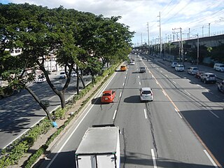
Commonwealth Avenue, formerly known as Don Mariano Marcos Avenue, is a 12.4-kilometer (7.7 mi) highway located in Quezon City, Philippines. It spans from six to eighteen lanes, making it the widest road in the country. The avenue is one of the major roads in Metro Manila and is designated as part of Radial Road 7 (R-7) of the older Manila arterial road system and National Route 170 (N170) of the Philippine highway network.

Circumferential Road 5 (C-5), informally known as the C-5 Road, is a network of roads and bridges which comprise the fifth beltway of Metro Manila in the Philippines. Spanning some 43.87 kilometers (27.26 mi), it connects the cities of Las Piñas, Parañaque, Pasay, Pasig, Quezon City, Taguig, and Valenzuela.
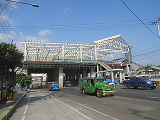
Tandang Sora station is an under-construction Metro Rail Transit (MRT) station located on the MRT Line 7 (MRT-7) system along Commonwealth Avenue in Matandang Balara and New Era, Quezon City.

Katipunan Avenue is a major avenue in Quezon City, Metro Manila, Philippines. It runs in a north–south direction from the University of the Philippines Diliman, intersecting with Tandang Sora Avenue at its northernmost point, down to the Manila Philippines Temple of the Church of Jesus Christ of Latter-day Saints, intersecting with White Plains Avenue at its southernmost point.

Mindanao Avenue is an eight-to-ten lane divided avenue connecting EDSA and NLEX and is a part of Circumferential Road 5 (C-5) in Metro Manila, Philippines. It is one of the three parallel roads that connects Tandang Sora and Congressional Avenues ; that is why it was named after the southernmost mainland of the Philippines, Mindanao. It used to be a 2-kilometer (1.2 mi) highway connecting North Avenue and Congressional Avenue, but as a part of the C-5 projects, Mindanao Avenue was extended to EDSA in the south and to Quirino Highway to the north. The new roads opened in 2000.

Aurora Boulevard is a four-to-ten lane major thoroughfare in Quezon City and San Juan in Metro Manila, Philippines. It was named after Doña Aurora Quezon, the consort of Commonwealth President Manuel Luis Quezon. It is one of the major roads in the commercial district of Araneta City in Cubao. Line 2 follows the alignment of the boulevard.

Congressional Avenue is a 6-kilometer (3.7 mi) highway located in Quezon City, Philippines, which spans from six lanes. It is one of the secondary roads in Metro Manila and part of it is designated as part of Circumferential Road 5 (C-5) of the Manila arterial road system and National Route 129 (N129) of the Philippine highway system.

West Avenue is a major road located in Quezon City within the Diliman area of northeastern Metro Manila, Philippines. It runs north–south through the western edge of the barangay of West Triangle. The street is located in Quezon City's commercial-residential area, known for its restaurants, car shops, schools, and villages. It is also home to the old Delta theater located on the avenue's junction with Quezon Avenue. The avenue is a component of National Route 171 (N171) of the Philippine highway network.
National Route 1 (N1) is a primary national route that forms part of the Philippine highway network, running from Luzon to Mindanao. Except for a 19-kilometer (12 mi) gap in Metro Manila and ferry connections, the highway is generally continuous. Most sections of N1 forms the Pan-Philippine Highway except for sections bypassed by expressways.

NLEX Harbor Link, signed as E5 of the Philippine expressway network, is a four- to six-lane expressway that serves as a spur of North Luzon Expressway (NLEX) linking it to the Port of Manila to the west and Quezon City to the east. It runs from Katipunan and C.P. Garcia Avenues in Quezon City to Radial Road 10 in Navotas, which in turn leads to the Port of Manila. Currently, its segment from Mindanao Avenue in Valenzuela to Navotas is operational.

National Route 62 (N62) forms part of the Philippine highway network. It runs south from Metro Manila to northeastern Cavite.

National Route 11 (N11) is an 18-kilometer (11 mi) major primary route that forms part of the Philippine highway network. It is a component and the main route of Circumferential Road 5 (C-5), connecting the cities of Taguig, Pasig and Quezon.

Tandang Sora Avenue, formerly known as Banlat Road, is a major east-west thoroughfare bisecting Quezon City in Metro Manila, Philippines. It is a two-to-six lane highway and municipal road that runs for 9.6 kilometers (6.0 mi) from its eastern terminus at Magsaysay Avenue in Pansol and U.P. Campus in Diliman to its western terminus at Quirino Highway in Baesa and Talipapa in Novaliches, crossing Barangays Culiat, New Era, Pasong Tamo, Tandang Sora, and Sangandaan.
National Route 180 (N180) is a secondary national route that forms part of the Philippine highway network, running from Cubao, Quezon City to Ermita, Manila.
National Route 170 (N170) is a national secondary road of the Philippine highway network. It passes through the northern part of Metro Manila, traversing through the cities of Quezon City, Manila, and Pasay.
F. Llamas Street is a national tertiary road in Cebu City, Cebu, Philippines. It commences at N. Bacalso Avenue in Barangay Basak San Nicolas, passes through the junction of Tres de Abril and E. Sabellano streets and ends at the junction of Katipunan Street in Barangay Tisa. It was formerly considered as a "national aid" city road under Executive Order No. 113 issued by President Ramon Magsaysay on May 2, 1955.

